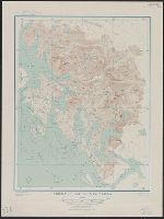
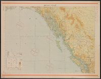
Carte géographique, statistique et historique des possessions Russes
Description:
From Buchon's Atlas géographique, statistique, historique et chronologique des deux Amériques et des îles adjacentes. 1825., In upper right: No. IV., and Includes inset of "Partie occidentale des îles Aleutiennes" and text surrounding map.
Publisher:
fonderie et imprimerie de J. Carez,
Subject (Geographic):
Alaska--Maps
Subject (Name):
Arnoul, Buchon, J. A. C. (Jean Alexandre C.), 1791-1846. Atlas géographique, statistique, historique et chronologique des deux Amériques et des îles adjacentes, Carez, J, and Le Gagneur
National Geographic Society (U.S.). Cartographic Division
Published / Created:
1975
Call Number:
848 1975
Container / Volume:
BRBL_00631
Image Count:
2
Resource Type:
Maps, Atlases & Globes
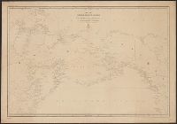
Description:
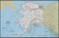
"Albers conical equal-area projection.", "Supplement to National Geographic, June 1975, page 730A, Vol. 147, no. 6 ... ", Includes inset of "Aleutian Islands.", Relief shown by shading and spot heights., Shows points of interest., and Text and illus. on verso.
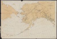
Also shows "reindeer country" in Eastern Siberia & steamboat lines., Date below subtitle: 1897., In lower right margin: S Doc 30 55 2., and Relief shown by hachures and spot heights.
Publisher:
s.n.,
Subject (Geographic):
Alaska--Maps
Subject (Name):
Jackson, Sheldon, 1834-1909 and Norris Peters Co
Subject (Topic):
Caribou--Alaska--Maps and Reindeer--Russia (Federation)--Siberia, Eastern--Maps
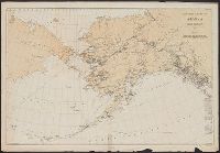
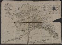
Also shows "reindeer country" in Eastern Siberia., In lower right margin: S Doc 70 57 2., Includes distance table., Library's copy annotated in red ink to indicate Episcopal missions., and Relief shown by hachures and spot heights.
Publisher:
s.n.],
Subject (Geographic):
Alaska--Maps
Subject (Name):
Jackson, Sheldon, 1834-1909
Subject (Topic):
Caribou--Alaska--Maps and Reindeer--Russia (Federation)--Siberia, Eastern--Maps
Japan. 陸地測量部., Japan. 陸軍. 参謀本部., and ジュノー--シヤトル / 陸地測量部, 参謀本部.
Description:
"Kōkūzu gunji himitsu (senchi ni arite wa 'bugaihi' to su) ", "Sanbyakuman-bun-no-ichi Han Taih, "三百万分一汎太平洋輿地圖十六號航空圖素圖.", Publication date of 1943 infered by date for the magnetic declination information on map., and Relief shown by contours and gradient tints.
Publisher:
s.n.],
Subject (Geographic):
Alaska--Maps, British Columbia--Maps, and Washington (State)--Maps
Subject (Name):
Japan. Rikuchi Sokuryōbu and Japan. Rikugun. Sanbō Honbu
Subject (Topic):
Aeronautical charts--Alaska, Aeronautical charts--British Columbia, and Aeronautical charts--Washington (State)
Generalʹnai︠a︡ karta Ledovitago mori︠a︡ i Vostochnago okeana, Генеральная карта Ледовитаго моря и Восточнаго океана, and Карта Ледовитаго моря и Восточнаго океана / составлена сь новѣйших описей в Географическом департаментѣ Морскаго министерства.
Description:
"1345" in lower left corner., "Noi︠a︡ 1858" in lower left corner., "Ноя. 1858" in lower left corner., Depths shown by soundings in coastal waters., Greenwich, Paris, and Petersburg meridians; Greenwich degrees numbered westward to 240°., and Includes Hydrographic
Subject (Geographic):
Alaska--Maps, Arctic Ocean--Maps, North Pacific Ocean--Maps, and Russian Far East (Russia)--Maps
Imperfect: chipped with some loss of text., Inset map of the Aleutian Islands., and Inset map showing the relative size of Alaska and the United States.