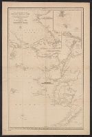
Russia. Gidrograficheskīĭ departament, creator Russia. Гидрографическій департамент
Published / Created:
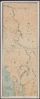
1858 Ii︠u︡ni︠a︡.
Call Number:
848cea B45 1858
Container / Volume:
BRBL_00635
Image Count:
1
Resource Type:
Maps, Atlases & Globes
Alternative Title:
Меркаторская карта Ледовитаго и Берингова морей с сѣверозападнымъ Беренгом Америки : отъ мыса Лисбурна до полуострова Аляски / составлена из разныхъ журналовъ и картъ и гравирована въ Гидрографическомъ департаментѣ Морскаго министерства, 1852.
Description:
"1455" in lower right corner., "No. 6, Vostochnago Okeana" above neat line., Insets: I︠A︡kornoe mi︠e︡sto i osva. Shamisso -- Port K, Mounted on linen., Publishing date in lower left corner., and Relief shown by hachures and spot heights. Depths shown by soundings.
Publisher:
[Morskoe ministerstvo],
Subject (Geographic):
Alaska--Maps, Bering Sea--Maps, Chukchi Peninsula (Russia)--Maps, and Chukchi Sea--Maps
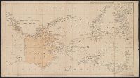
J.H. Colton & Co United States. District Court (New York : Southern District)
Published / Created:
[1855]
Call Number:
18 1860
Container / Volume:
BRBL_00013
Image Count:
1
Resource Type:
Maps, Atlases & Globes
Description:
"Entered according to an act of Congress in the year 1855 by J.H. Colton & Co. in the Clerks Office of the District Court of the United States for the southern district of New York.", Relief shown by hachures and isolines., and Torn in two halves.
In lower margin: Ship your freight by, or travel to Alaska, via the Northwestern Steamship Co. Ltd., Seattle., Relief shown by hatchures., and Shows Northwestern Steamship Company routes from Seattle to destinations in Alaska.
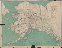
"Distances from Juneau to the mouth of the Porcupine River"., Ms. notes recto and verso., Oriented with north toward upper right., and Relief shown by hachures and spot heights.
Publisher:
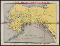
U.S. Coast and Geodetic Survey,
Subject (Geographic):
Alaska--Maps, British Columbia--Maps, and Yukon--Maps
Includes inset of Aleutian Islands., Index and distance table on verso., Relief shown by hachures and spot heights., and Shows mineral resources, steamship routes, glaciers, cable lines, etc.
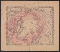
National Geographic Society (U.S.). Cartographic Division
Published / Created:
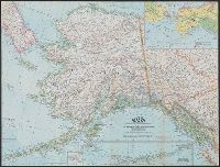
1959
Call Number:
848 1959
Container / Volume:
BRBL_00631
Image Count:
1
Resource Type:
Maps, Atlases & Globes
Alternative Title:
Atlas plate ; 18
Description:
Aleutian Islands mapping continued on inset., Includes inset on vegetation and land use., Includes insets: Vegetation and land use -- Diomede Islands., and Supplement to July, 1959 issue of the National Geographic magazine.
"The base is a copy of a part of chart T of the U.S. Coast and Geodetic Survey, edition of June 1897.", Insets: Trails from tide water to the headwaters of the Yukon River, Alaska--The Klondike gold region, Canada., Published January, 1898., and Relief shown by hachures and spot heights.
Subject (Geographic):
Alaska--Maps
Subject (Name):
U.S. Coast and Geodetic Survey
Subject (Topic):
Coal mines and mining--Alaska--Maps, Gold mines and mining--Alaska--Maps, Mail steamers--Alaska--Maps, and Trails--Alaska--Maps