Search
You Searched For
Search Results
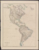
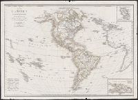
- Creator:
- Arrowsmith, John, 1790-1873
- Published / Created:
- 1832 February 15
- Call Number:
- 70 1832
- Container / Volume:
- BRBL_00359
- Image Count:
- 1
- Resource Type:
- Maps, Atlases & Globes
- Description:
- In upper right margin: 39.
- Publisher:
- J. Arrowsmith, 35 Essex Strand,
- Subject (Geographic):
- America--Maps
- Found in:
- Beinecke Rare Book and Manuscript Library > America / by J. Arrowsmith.
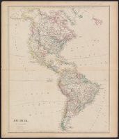
- Creator:
- Arrowsmith, John, 1790-1873
- Published / Created:
- 1844 February 15
- Call Number:
- 70 1844
- Container / Volume:
- BRBL_00359
- Image Count:
- 1
- Resource Type:
- Maps, Atlases & Globes
- Description:
- "39."
- Publisher:
- J. Arrowsmith, 10 Soho Square,
- Subject (Geographic):
- America--Maps
- Subject (Name):
- Arrowsmith, John, 1790-1873. London atlas of universal geography
- Found in:
- Beinecke Rare Book and Manuscript Library > America / by J. Arrowsmith.
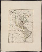
- Creator:
- Wilkinson, Robert, -approximately 1825
- Published / Created:
- 18th Oct. 1822.
- Call Number:
- 70 1822
- Container / Volume:
- BRBL_00358
- Image Count:
- 1
- Resource Type:
- Maps, Atlases & Globes
- Description:
- Includes text.
- Publisher:
- Robert Wilkinson, no. 125 Fenchurch St.,
- Subject (Geographic):
- America--Maps
- Found in:
- Beinecke Rare Book and Manuscript Library > America.
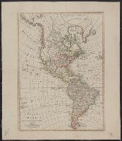
- Creator:
- Hérisson, Eustache, 1759-
- Published / Created:
- 1831
- Call Number:
- 70 1831
- Container / Volume:
- BRBL_00359
- Image Count:
- 1
- Resource Type:
- Maps, Atlases & Globes
- Description:
- Includes text and inset of "Supplément à la partie nord de l'Amérique."
- Publisher:
- chez Jean, rue S. Jean de Beauvais, no. 10,
- Subject (Geographic):
- America--Maps
- Found in:
- Beinecke Rare Book and Manuscript Library > Carte de l'Amérique septentrionale et méridionale, divisée en ses principaux états : pour servir à l'instruction de la jeunesse / par Hérisson, géographe.
- Published / Created:
- 1821
- Call Number:
- 70 1821
- Container / Volume:
- BRBL_00725
- Image Count:
- 1
- Resource Type:
- Maps, Atlases & Globes
- Description:
- Hand col. Preliminary record. Franklin Collection no. 131 1821.
- Publisher:
- Bey Christoph Fembo,
- Subject (Geographic):
- America--Maps
- Found in:
- Beinecke Rare Book and Manuscript Library > Charte von America ... / von I.N. Diewald.
- Published / Created:
- 1820
- Call Number:
- 70 1820
- Container / Volume:
- BRBL_00358
- Image Count:
- 1
- Resource Type:
- Maps, Atlases & Globes
- Description:
- "Der nördliche Theil von America nach Cook, Hearne, Vancouver, und Mackenzie."
- Publisher:
- Verlage des Geograph Instituts,
- Subject (Geographic):
- America--Maps
- Subject (Name):
- Verlage des Geograph Instituts
- Found in:
- Beinecke Rare Book and Manuscript Library > Charte von America : nach den neuesten Berichten und Entdeckungen entworfen.
- Published / Created:
- 1809
- Call Number:
- 70 1809
- Container / Volume:
- BRBL_00358
- Image Count:
- 1
- Resource Type:
- Maps, Atlases & Globes
- Description:
- "Der nördliche Theil von America nach Cook, Hearne, Vancouver, und Mackenzie."
- Publisher:
- Verlage des Geograph Instituts,
- Subject (Geographic):
- America--Maps
- Subject (Name):
- Verlag des Geograph. Instituts
- Found in:
- Beinecke Rare Book and Manuscript Library > Charte von America : nach den neuesten Berichten und Entdeckungen entworfen.
- Creator:
- Streit, F. W
- Published / Created:
- 1820
- Call Number:
- 70 1820A
- Container / Volume:
- BRBL_00358
- Image Count:
- 1
- Resource Type:
- Maps, Atlases & Globes
- Description:
- Includes inset of Alaska.
- Publisher:
- Verlage des Geograph Instituts,
- Subject (Geographic):
- America--Maps
- Subject (Name):
- Verlage des Geograph Instituts
- Found in:
- Beinecke Rare Book and Manuscript Library > Charte von America : nach den neuesten Materialien sichersten Ortsbestim̄ungen und der neuesten Eintheilung entworfen / von Friedr. Wilh. Streit, Ober=Lieutnant.
- Creator:
- Fried, Franz
- Published / Created:
- 1823
- Call Number:
- 70 1823
- Container / Volume:
- BRBL_00358
- Image Count:
- 1
- Resource Type:
- Maps, Atlases & Globes
- Description:
- Relief shown by hachures.
- Publisher:
- Artaria et Comp.,
- Subject (Geographic):
- America--Maps
- Subject (Name):
- Artaria & Co
- Found in:
- Beinecke Rare Book and Manuscript Library > Karte von America / gezeichnet von F. Fried.
- Creator:
- Bordiga, Giovanni Battista, 1799-
- Published / Created:
- 1823
- Call Number:
- 70 1823
- Container / Volume:
- BRBL_00358
- Image Count:
- 1
- Resource Type:
- Maps, Atlases & Globes
- Alternative Title:
- Isola della Martinica and Isola di S. Domingo
- Description:
- Insets: Isola della Martinica -- Isola di S. Domingo.
- Publisher:
- Presso P. e Gius[epp]e Vallardi ...,
- Subject (Geographic):
- America--Maps, Dominican Republic--Maps, Haiti--Maps, and Martinique--Maps
- Subject (Name):
- Bossi, Luigi, 1758-1835. Nuovo atlante universale and Brué, Adrien Hubert, 1786-1832
- Found in:
- Beinecke Rare Book and Manuscript Library > L'America settentrionale e meridionale : secondo le sue ultime scoperte e divisione politiche / costrutta ed incisa da Gio. Batt. Bordiga sopra quella di H. Brué.