Anville, Jean Baptiste Bourguignon d', 1697-1782 Cook, James, 1728-1779 Kitchin, Thomas, d. 1784, creator Sayer, Robert, 1725-1794
Published / Created:
1787 January 6
Call Number:
1982 Folio 10
Image Count:
2
Description:
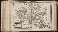
Also appeared in Kitchin's General atlas describing the whole universe. London : Printed for Robert Sayer, [1780]., No. 29 of 43 maps bound together in composite atlas., Relief shown pictorially., Scale [ca. 1:11,100,000]., Sheets mounted together to form 2 sheets., Shows boundaries, rivers, settlements, islands; includes descriptive notes., and Title cartouche depicts local produce, a palm tree and a camel.
At head of map: Asia distinguished into its principall parts viz. Turky in Asia, Arabia, Persia, India, China, Tartaria, the islands of Japan, of the Philippines, of the Moluckes, of the Sundaes, of Ceylan, and of the Maldivies, where are set down the empires, monarchies, kingdoms, and states which are found there at present., Dedication in cartouche: To the most serene and most sacred majesty of Charles II by the grace of God, King of Great Brittain, France and Ireland. This map of Asia is humbly dedicated, and presented by your majesties loyal subject, and servant William Berry., Map of Asia from Saudi Arabia, Russia, India, China, Japan to Southeast Asia. Relief shown pictorially., No. 49 of 69 maps bound together in composite atlas., and Scale [ca. 1:12 165 120].
Publisher:
Sold by William Berry at the signe of the Globe between Charing-Cross and White-Hall
Subject (Geographic):
Asia --Maps --Early works to 1800, Asia, Central --Maps --Early works to 1800, South Asia --Maps --Early works to 1800, and Southeast Asia --Maps --Early works to 1800
Boehm, Augustus Gottlieb Hase, Johann Matthias, 1684-1742 Homann Erben (Firm)
Published / Created:
1744
Call Number:
1983 Folio 23
Collection Title:
[Atlas factice of 50 maps, primarily by Johann Baptist Homann and/or issued by the Homann Erben
Image Count:
1
Alternative Title:
Asia secundum legitimas projectionis stereographicae regulas et juxta recentissimas observationes and Carte de l’Asie, projettee stereographiquement, tiree des relations et observations
Boehm, Augustus Gottlieb Hase, Johann Matthias, 1684-1742 Homann Erben (Firm)
Published / Created:
1744
Call Number:
1975 Folio 31
Collection Title:
[Atlas factice of 42 maps, produced by the Homann Erben firm]
Image Count:
1
Alternative Title:
Asia secundum legitimas projectionis stereographicae regulas et juxta recentissimas observationes and Carte de l’Asie, projettee stereographiquement, tiree des relations et observations
[Atlas factice of 96 maps by Blaeu, Visscher, Jansson, Hondius and others]
Image Count:
2
Resource Type:
Maps, Atlases & Globes
Description:
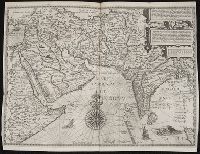
All four sides of map decorated with city views and costumed figures of different social classes. Includes coats of arms., Imperfect: torn along fold, with some loss of text; portions of decorative border cut or torn and repaired, with missing sections replicated in ms.; tears repaired., and No. 5 of 92 maps bound together.
... Iohn Hvighen van Linschoten. his Discours of Voyages into ye Easte & West Indies. Deuided into
Image Count:
1
Description:
[Scale ca. 1:13,500,000]., Bound in following title page of book three., In ink on verso: "10" crossed out in ink with two lines., In ink on verso: 307., In ink on vesro: X., and Map properly belongs to the Dutch edition of 1596.
Subject (Geographic):
Africa --Maps --Early works to 1800, Arabian Peninsula --Maps --Early works to 1800, Arabian Sea --Charts, maps, etc., Armenia (Republic) --Maps, Asia --Maps --Early works to 1800, Bengal, Bay of --Maps, Cyprus --Maps --Early works to 1800, India --Maps --Early works to 1800, Mediterranean Sea --Maps --Early works to 1800, Syria --Maps, Tigris River Valley, and Yemen --Maps --Early works to 1800
Subject (Topic):
Voyages and travels --Early works to 1800
Collection Created:
Printed at London by Iohn Wolfe Printer to ye Honorable Cittie of London [1598]