Search
You Searched For
Search Results
- Creator:
- Freducci, Conte di Ottomano, active 1497-1539, cartographer
- Published / Created:
- [1536?]
- Call Number:
- Covers 49 +1536
- Image Count:
- 6
- Resource Type:
- cartographic image
- Description:
- Title devised by cataloger.
- Publisher:
- Conte di Ottomano Freducci
- Subject (Geographic):
- Mediterranean Region, North Atlantic Ocean, and Baltic Sea
- Subject (Topic):
- Nautical charts and Maps
- Found in:
- Beinecke Rare Book and Manuscript Library > Composite atlas of portolan charts produced by Conte di Ottomano Freducci
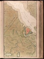
- Creator:
- Keulen, Gerard van, cartographer
- Published / Created:
- [1734]
- Call Number:
- 1973 Folio 18
- Image Count:
- 1
- Description:
- BEIN 1973 Folio 18: Backed with paper. Ms. no. "13" in upper right-hand corner. Sheet measures 53.6 x 35.5 cm. No. 13 of 87 maps bound together.
- Publisher:
- By Gerard van Keulen ...
- Subject (Geographic):
- Rügen Island (Germany), Stralsund (Germany), and Baltic Sea
- Subject (Topic):
- Northern War, 1700-1721, Maps, and Nautical charts
- Found in:
- Beinecke Rare Book and Manuscript Library > De kust van Pomeren, hey eyland Rugen [cartographic material].
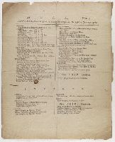
- Published / Created:
- [1760]
- Call Number:
- File 18 H913+
- Image Count:
- 1
- Description:
- Single sheet publication. Printed in two columns.
- Publisher:
- s.n.
- Subject (Geographic):
- England, Hull., and Baltic Sea
- Subject (Topic):
- Imports, Exports, Shipping, and Commerce
- Found in:
- Lewis Walpole Library > Hull
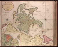
- Creator:
- Keulen, Gerard van, cartographer
- Published / Created:
- [1734]
- Call Number:
- 1973 Folio 18
- Image Count:
- 1
- Description:
- BEIN 1973 Folio 18: Backed with paper. Ms. no. "13" in upper right-hand corner. Sheet measures 53.6 x 62.8 cm. No. 12 of 87 maps bound together.
- Publisher:
- By Gerard van Keulen ...
- Subject (Geographic):
- Rügen Island (Germany), Stralsund (Germany), and Baltic Sea
- Subject (Topic):
- Maps and Nautical charts
- Found in:
- Beinecke Rare Book and Manuscript Library > Nieuwe afteekening van het eyland Rugen en de Straalsond als mede de stad Straalsond en t Nieuwe diep met alle desselfs gelegentheden int groot. [cartographic material]