Search
You Searched For
Search Results
- Creator:
- Nell, Louis
- Published / Created:
- 1887
- Call Number:
- 777 B21 1887
- Container / Volume:
- BRBL_00503
- Image Count:
- 1
- Resource Type:
- Maps, Atlases & Globes
- Description:
- "Contours in water one fathom apart."
- Publisher:
- Johns Hopkins University,
- Subject (Geographic):
- Baltimore (Md.)--Maps and Baltimore Region (Md.)--Maps
- Subject (Name):
- Johns Hopkins University, U.S. Coast and Geodetic Survey, and Webster, Albert L
- Found in:
- Beinecke Rare Book and Manuscript Library > Baltimore and its neighborhood : an excursion map / compiled for the Johns Hopkins University ; based upon the triangulation of the U.S. Coast and Geodetic Survey and published maps of local surveys ; edited by Albert L. Webster ; drawn by Louis Nell.
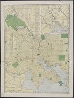
- Creator:
- Rand McNally and Company
- Published / Created:
- 1907
- Call Number:
- 777 B21 1907
- Container / Volume:
- BRBL_00503
- Image Count:
- 1
- Resource Type:
- Maps, Atlases & Globes
- Alternative Title:
- Map of Baltimore and environs
- Description:
- Identifies street names, major buildings, and street car lines.
- Publisher:
- Rand McNally & Co.,
- Subject (Geographic):
- Baltimore (Md.)--Maps
- Found in:
- Beinecke Rare Book and Manuscript Library > Baltimore.
- Creator:
- Maryland Geological Survey
- Published / Created:
- 1912
- Call Number:
- 777cbf B21 1912
- Container / Volume:
- BRBL_00504A
- Image Count:
- 1
- Resource Type:
- Maps, Atlases & Globes
- Description:
- "With cooperation of U.S. Geological Survey, Baltimore Topographic Survey, Baltimore Harbor Board"
- Publisher:
- The Survey,
- Subject (Geographic):
- Baltimore (Md.)--Maps
- Subject (Name):
- Baltimore Harbor Board, Baltimore Topographic Survey, and Geological Survey (U.S.)
- Subject (Topic):
- Real property--Maryland--Baltimore--Maps
- Found in:
- Beinecke Rare Book and Manuscript Library > Baltimore.
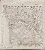
- Published / Created:
- 1896
- Call Number:
- 777cbf B21 1894
- Container / Volume:
- BRBL_00504
- Image Count:
- 36
- Resource Type:
- Maps, Atlases & Globes
- Description:
- "Contour interval 5 ft. Datum, mean low water at Baltimore."
- Publisher:
- Photo-Lith. by A. Hoen,
- Subject (Geographic):
- Baltimore (Md.)--Maps
- Subject (Name):
- A. Hoen & Co and Douglas, H. T
- Found in:
- Beinecke Rare Book and Manuscript Library > City of Baltimore topographical survey / made under the direction of H.T. Douglas, chief engineer.
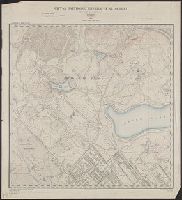
- Published / Created:
- 1894
- Call Number:
- 777 B21 1894A
- Container / Volume:
- BRBL_00503
- Image Count:
- 1
- Resource Type:
- Maps, Atlases & Globes
- Description:
- "Contour interval 5 ft. Datum, mean low water at Baltimore.".
- Publisher:
- Photo-Lith. by A. Hoen,
- Subject (Geographic):
- Baltimore (Md.)--Maps
- Subject (Name):
- A. Hoen & Co and Douglas, H. T
- Found in:
- Beinecke Rare Book and Manuscript Library > City of Baltimore topographical survey : Sheet 1N. - 4W. / made under the direction of H.T. Douglas, chief engineer.
- Published / Created:
- 1894
- Call Number:
- 777 B21 1894A
- Container / Volume:
- BRBL_00503
- Image Count:
- 1
- Resource Type:
- Maps, Atlases & Globes
- Description:
- "Contour interval 5 ft. Datum, mean low water at Baltimore.".
- Publisher:
- Photo-Lith. by A. Hoen,
- Subject (Geographic):
- Baltimore (Md.)--Maps
- Subject (Name):
- A. Hoen & Co and Douglas, H. T
- Found in:
- Beinecke Rare Book and Manuscript Library > City of Baltimore topographical survey : Sheet 2N. - 2W. / made under the direction of H.T. Douglas, chief engineer.
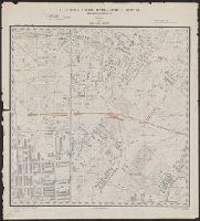
- Creator:
- Wm. A. Flamm & Co
- Published / Created:
- c1918.
- Call Number:
- 777 B21 1918
- Container / Volume:
- BRBL_00503
- Image Count:
- 1
- Resource Type:
- Maps, Atlases & Globes
- Alternative Title:
- Index map Baltimore.
- Publisher:
- Wm.A. Flamm,
- Subject (Geographic):
- Baltimore (Md.)--Maps
- Subject (Topic):
- Streets--Maryland--Baltimore--Maps
- Found in:
- Beinecke Rare Book and Manuscript Library > Flamm's index map Baltimore.
- Creator:
- Wm. A. Flamm & Co
- Published / Created:
- 1894
- Call Number:
- 777 B21 1894
- Container / Volume:
- BRBL_00503
- Image Count:
- 1
- Resource Type:
- Maps, Atlases & Globes
- Description:
- Includes street index.
- Publisher:
- Flamm & Co.],
- Subject (Geographic):
- Baltimore (Md.)--Maps
- Found in:
- Beinecke Rare Book and Manuscript Library > Flamm's new map of Baltimore, 1894.
- Published / Created:
- 1801
- Call Number:
- 777 B21 1801
- Container / Volume:
- BRBL_00503
- Image Count:
- 1
- Resource Type:
- Maps, Atlases & Globes
- Description:
- 2 views: New Assembly Room; View of the market space Canal.
- Subject (Geographic):
- Baltimore (Md.)--Maps
- Found in:
- Beinecke Rare Book and Manuscript Library > Warner & Hanna's Plan of the City and Environs of Baltimore, Respectfully dedicated to the Mayor City Council, & Citizens thereof, by the Proprietors, 1801.