Skip to search
Skip to main content
Skip to first result
Search
You Searched For
Subject (Geographic)
Black Sea
Search Results
Creator:
Published / Created:
[approximately 1450-1475]
Call Number:
Art Storage 49cea 1425
Image Count:
2
Resource Type:
cartographic image
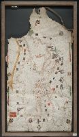
Description:
BEIN Art Storage 49cea 1425: Imperfect: lower left corner and bottom edge torn, with some loss of map; slight holes throughout. With leather thone tie on left edge.
Publisher:
Petrus Roselli?
Subject (Geographic):
Mediterranean Sea and Black Sea
Subject (Topic):
Maps and Nautical charts
Found in:
Beinecke Rare Book and Manuscript Library > Portolan chart of the Mediterranean Sea and the Black Sea
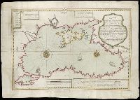
Creator:
Published / Created:
Octr. 24th, 1787.
Call Number:
1982 Folio 10
Image Count:
1
Alternative Title:
Map of the present seat of war, between the Russians, Poles, and Turk
Description:
BEIN 1982 Folio 10: Includes paste-on addition to northwestern sheet depicting Bosnia, Herzegovina, and the Dalmatian Coast. Armorial bookplate: Charles Abbot. No. 25 of 42 maps bound together.
Publisher:
Wm. Faden
Subject (Geographic):
Black Sea and Russia
Subject (Topic):
Russo-Turkish War, 1787-1792
Found in:
Beinecke Rare Book and Manuscript Library > To his excellency the Count of Czernichew, commander in chief of her Majesty the Empress of all the Russia's fleet and gallies ... : map of the present seat of war, between the Russians, Poles, and Turks is most humbly inscribed ...
Published / Created:
1724 or 1725]
Call Number:
492 1723
Image Count:
2
Description:
Title supplied by cataloger.
Publisher:
Ibrahim Mutafarrikah
Subject (Geographic):
Black Sea and Black Sea Coast
Subject (Topic):
Maps
Found in:
Beinecke Rare Book and Manuscript Library > [Chart of the Black Sea] [cartographic material].
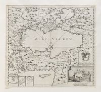
Creator:
Published / Created:
an[n]o 1637.
Call Number:
2022 Folio 31
Image Count:
1
Resource Type:
cartographic image
Description:
Portolan chart with seaport names given for all coastlines.
Publisher:
[Placidus Cal]oiro et Oliua fecit in nobili urbe Messanae
Subject (Geographic):
Mediterranean Sea and Black Sea
Subject (Topic):
Maps and Nautical charts
Found in:
Beinecke Rare Book and Manuscript Library > [Portolan chart of the Mediterranean Sea and the Black Sea, with the Atlantic coast from the Netherlands to Morocco, including southern Ireland and southern England].
Published / Created:
[approximately 1960]
Call Number:
Art Storage 1019
Image Count:
2
Resource Type:
cartographic image
Description:
Twentieth century forgery of a portlan chart with seaport names given for all coastlines; based on chart from the circle of Vesconte Maggiolo.
Subject (Geographic):
Mediterranean Sea, North Atlantic Ocean, Black Sea, Africa, West, Mediterranean Sea., North Atlantic Ocean., Black Sea., and Africa, West.
Subject (Topic):
Nautical charts
Found in:
Beinecke Rare Book and Manuscript Library > [Portolan chart of the Mediterranean Sea, the North Atlantic Ocean, the Black Sea, and the northwestern African coast].
Creator:
Published / Created:
[1732?]
Call Number:
Folio 75 H67 800 v.1 (Oversize)
Image Count:
1
Abstract:
Small depiction of two camels being fed by a man; engraved within a rectangular border in the lower right corner of a map of the the Black Sea
Alternative Title:
Mare Nigrum
Description:
Title from Paulson. Questionable attribution to Hogarth in 2nd ed.; rejected attribution in 3rd edition.
Publisher:
publisher not identified
Subject (Geographic):
Black Sea
Subject (Topic):
Camels
Found in:
Lewis Walpole Library > [Two dromedaries] [graphic].