
You Searched For
1 - 4 of 4
Search Results

2.
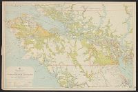
- Creator:
- British Columbia. Dept. of Lands
- Published / Created:
- 1929
- Call Number:
- 7391 1929
- Container / Volume:
- BRBL_00394
- Image Count:
- 1
- Resource Type:
- Maps, Atlases & Globes
- Alternative Title:
- Vancouver Island
- Description:
- "Map No. 2C.", "May 1st, 1929.", Inset: Scott Islands., Relief shown by spot heights., and Shows crown granted land, surveyed timber leases and licenses, Indian reserves, government reserves, railways, roads, trails, etc.
- Publisher:
- Dept. of Lands,
- Subject (Geographic):
- British Columbia--Administrative and political divisions--Maps and Vancouver Island (B.C.)--Maps
- Subject (Name):
- Aitken, G. G
- Subject (Topic):
- Land grants--British Columbia--Vancouver Island--Maps and Logging--Licenses--British Columbia--Vancouver Island--Maps
- Found in:
- Beinecke Rare Book and Manuscript Library > Northerly portion, Vancouver Island / G.G. Aitken, chief geographer.
3.
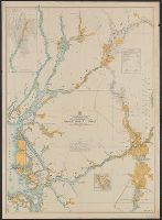
- Creator:
- British Columbia. Dept. of Lands
- Published / Created:
- 1929
- Call Number:
- 739FCM 1929
- Container / Volume:
- BRBL_00391
- Image Count:
- 1
- Resource Type:
- Maps, Atlases & Globes
- Alternative Title:
- Preemptor's map, Prince Rupert sheet and Prince Rupert sheet
- Description:
- "Map No. 3M.", Includes index map., Inset: [Portland Cana, Relief shown by spot heights., and Shows land recording divisions, land recording offices, surveyed lands, land district boundaries, post offices, schools, telegraph and telephone lines, roads and trails.
- Publisher:
- Dept. of Lands,
- Subject (Geographic):
- British Columbia--Administrative and political divisions--Maps, Nass River Region (B.C.)--Maps, Prince Rupert Forest Region (B.C.)--Maps, and Skeena River Region (B.C.)--Maps
- Subject (Topic):
- Land grants--British Columbia--Prince Rupert Forest Region--Maps, Land use--British Columbia--Prince Rupert Forest Region--Maps, and Public lands--British Columbia--Prince Rupert Forest Region--Maps
- Found in:
- Beinecke Rare Book and Manuscript Library > Pre-emptor's map, Prince Rupert sheet.
4.

- Creator:
- British Columbia. Dept. of Lands
- Published / Created:
- 1912
- Call Number:
- 739 1912
- Container / Volume:
- BRBL_00388
- Image Count:
- 1
- Resource Type:
- Maps, Atlases & Globes
- Description:
- Map of land districts of southwestern British Columbia. and Relief shown by hachures and spot heights.
- Publisher:
- The Department],
- Subject (Geographic):
- British Columbia--Administrative and political divisions--Maps
- Found in:
- Beinecke Rare Book and Manuscript Library > South western districts / British Columbia Department of Lands ; G.H. Dawson Surveyor-general.