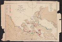
Discoveries of Captains Ross, Parry & Franklin in the Arctic regions, from the year 1818 to 1827
Description:
"Drawn & engraved for Thomson's New general atlas.", In upper right margin: 76., Insets: [Northern Alaska and the mouth of the Mackenzie River] -- Capt. Franklin's journey from Coppermine River, to th, Relief shown by hachures., and Stamp of William Inglis Morse.
Publisher:
For J. Thomson & Co.,
Subject (Geographic):
Canada, Northern--Discovery and exploration--Maps
Subject (Name):
Aspin, Jehoshaphat, 18th/19th cent, Franklin, John,--Sir,--1786-1847--Travel, Hewitt, N. R, Morse, William Inglis,--b. 1874--Stamp, Parry, William Edward,-, and Thomson, John, 19th cent. New general atlas
Aspin, Jehoshaphat, active 18th century-19th century
Published / Created:
yd. January 1, 1827.
Call Number:
BrSides 2019 10
Image Count:
1
Resource Type:
Maps, Atlases & Globes
Description:
"Hewitt, Sculp. St. John's Wood.", Mounted on linen. Manuscript title on verso. Autograph of William H. Brewer on recto and verso. Stamps of the Library of the Department of Geology, Yale University., and Relief shown by hachures.
Publisher:
Pub.d as the act directs by J. Harris, St. Pauls Ch,