Search
You Searched For
Search Results
- Creator:
- Mackenzie, Alexander, 1764-1820
- Published / Created:
- 1801
- Call Number:
- 73 1801
- Container / Volume:
- BRBL_00374
- Image Count:
- 1
- Resource Type:
- Maps, Atlases & Globes
- Description:
- "... Published 15 Oct. 1801 ..."
- Publisher:
- Published by Alexander Mack Kenzie,
- Subject (Geographic):
- Canada--Discovery and exploration--Maps and Canada--Maps
- Subject (Name):
- Mackenzie, Alexander,--1764-1820--Travel--Maps
- Found in:
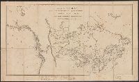
- Beinecke Rare Book and Manuscript Library > A map of America between latitudes 40 and 70 north and longitudes 45 and 180 west exhibiting Mackenzie's track from Montreal to Fort Chipewyan & from thence to the north sea in 1789 & to the west Pacific Ocean in 1793.
- Creator:
- Mackenzie, Alexander, 1764-1820
- Published / Created:
- 1801
- Call Number:
- 73 1801
- Container / Volume:
- BRBL_00374
- Image Count:
- 1
- Resource Type:
- Maps, Atlases & Globes
- Description:
- "... Published 15 Oct. 1801 ..."
- Publisher:
- Published by Alexander Mack Kenzie,
- Subject (Geographic):
- Canada--Discovery and exploration--Maps and Canada--Maps
- Subject (Name):
- Mackenzie, Alexander,--1764-1820--Travel--Maps
- Found in:
- Beinecke Rare Book and Manuscript Library > A map of America between latitudes 40 and 70 north and longitudes 45 and 180 west exhibiting Mackenzie's track from Montreal to Fort Chipewyan & from thence to the north sea in 1789 & to the west Pacific Ocean in 1793.
- Published / Created:
- 191-?]
- Call Number:
- 73bh 1912
- Container / Volume:
- BRBL_00375A
- Image Count:
- 1
- Resource Type:
- Maps, Atlases & Globes
- Description:
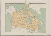
- In upper margin, left to right: Routes of explorers, 57, 58, Atlas of Canada.
- Publisher:
- s.n.,
- Subject (Geographic):
- Canada--Discovery and exploration--Maps
- Subject (Topic):
- Explorers--Canada--Maps
- Found in:
- Beinecke Rare Book and Manuscript Library > Routes of explorers : [in Canada].