Robert de Vaugondy, Gilles, 1688-1766, cartographer.
Call Number:
73 1785
Image Count:
1
Resource Type:
Maps, Atlases & Globes
Alternative Title:
Partie de l'Amérique septent[rionale] qui comprend la Nouvelle France ou le Canada
Description:
Decorative title cartouche by Graux., Fourth state with date in cartouce removed., From the author's Atlas universel., Inset of "Supplement pour les lacs du Canada" (scale approximately 1:5,500,000)., Relief shown pictorially., and Watermark.
Subject (Geographic):
Canada--Maps--Early works to 1800., Great Lakes Region (North America)--Maps--Early works to 1800., and New France--Maps--Early works to 1800.
Subject (Name):
Robert de Vaugondy, Gilles, 1688-1766. Atlas universel.
Partie de l'Amérique septent[rionale] qui comprend la Nouvelle France ou le Canada
Description:
"Avec privilege 1755.", "C. Haussard sculp.", "Wm. Inglis Morse Collection" -- on recto in upper right corner. Stamp on verso: Canada. No. on verso: 103., From the author's Atlas universel. 1757[-1758]., Inset of "Supplement pour les lacs du Canada." Scale [ca. 1:5,500,000]., Relief shown pictorially., Second state, with "I. Charlton" in James Bay named and the location and orientation of "F. de la Presqu'íle" changed., and Watermark.
Publisher:
s.n.,
Subject (Geographic):
Canada--Maps--Early works to 1800., Great Lakes Region (North America)--Maps--Early works to 1800., and New France--Maps--Early works to 1800.
Subject (Name):
George Washington's American Atlas., Haussard, Catherine, engraver., Morse, William Inglis,--b. 1874--Stamp., Robert de Vaugondy, Gilles, 1688-1766. Atlas universel., and Washington, George,--1732-1799--Ownership.
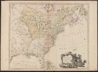
Covers the area from Lake Superior to Kaskaskia and from Delaware Bay to the Mississippi River., Relief shown pictorially., Shows a few towns, missions, forts, Indian villages and tribal territory, rivers and lakes, portages, and early place-names., and Watermark.
Publisher:
[Homann Erben?],
Subject (Geographic):
Canada--Maps--Early works to 1800., Great Lakes Region (North America)--Maps--Early works to 1800., and New France--Maps--Early works to 1800.