Skip to search
Skip to main content
Skip to first result
Search
You Searched For
Subject (Geographic)
Caucasus--Maps
New Search
Search Results
Creator:
Published / Created:
1942
Call Number:
354 1942
Container / Volume:
BRBL_00112
Image Count:
1
Resource Type:
Maps, Atlases & Globes
Alternative Title:
[G.S.G.S.] 4327 and GSGS (Series) ; 4327.
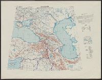
Description:
"Copied from a map produced by 512 (A. Fd. svy.) coy. R.E., January 1942 and collated by Mid-Asiatic bureau M.E.", In lower right corner of margin: Reprint November 1942., Relief shown by hachures and shading., and Two gauges of railroads, principal roads and tr
Publisher:
Army Map Service, U.S. Army,
Subject (Geographic):
Caucasus--Maps
Found in:
Beinecke Rare Book and Manuscript Library > Caucasia and neighbouring territories.
Creator:
Published / Created:
1908
Call Number:
354 1906
Container / Volume:
BRBL_00112
Image Count:
1
Resource Type:
Maps, Atlases & Globes
Alternative Title:
G.S.G.S. ; no. 2167 and GSGS (Series) ; 2167.
Publisher:
War Office],
Subject (Geographic):
Caucasus--Maps
Subject (Name):
Great Britain. War Office. General Staff. Geographical Survey
Found in:
Beinecke Rare Book and Manuscript Library > Caucasia.
Published / Created:
191-.
Call Number:
11hcf 1919D-30
Image Count:
1
Resource Type:
Maps, Atlases & Globes
Description:
Scale given in versts, miles, and kilometers. and Shows Caucasus Mountains.
Publisher:
s.n.,
Subject (Geographic):
Caucasus--Maps
Found in:
Beinecke Rare Book and Manuscript Library > Caucasia.
Published / Created:
191-.
Call Number:
11hcf 1919D-31
Container / Volume:
BRBL_00010X
Image Count:
1
Resource Type:
Maps, Atlases & Globes
Description:
Shows region of Caucasus Mountains, indicating towns, provincial boundaries and railway lines.
Publisher:
s.n.,
Subject (Geographic):
Caucasus--Maps
Found in:
Beinecke Rare Book and Manuscript Library > Caucasus.
Creator:
Published / Created:
[1941]
Call Number:
354eb 1941
Container / Volume:
BRBL_00113
Image Count:
1
Resource Type:
Maps, Atlases & Globes
Description:
"No. 32.", Includes lengend and inset showing relative size of cities., and Transfer line print.
Publisher:
C.O.I.,
Subject (Geographic):
Caucasus--Maps
Subject (Topic):
Population density--Caucasus--Maps
Found in:
Beinecke Rare Book and Manuscript Library > Density of population (rural) / Geographic Div. - C.O.I.
Creator:
Published / Created:
1942
Call Number:
354am 1942
Container / Volume:
BRBL_00113
Image Count:
1
Resource Type:
Maps, Atlases & Globes
Alternative Title:
Bilder der Woche ; Nr. 156.
Description:
In bottom margin: Folge 156 vom 8. November 1942. and Incl. panel with text and ill.
Publisher:
Luftwaffenführungsstab I c/VI, and Oberkommando der Wehrmacht (Abteilung Inland) ;
Subject (Geographic):
Caucasus--Maps
Found in:
Beinecke Rare Book and Manuscript Library > Der Kaukasus / Verlag und Druck August Scherl Nachf. (Scherl-Bilderdienst).
Published / Created:
1910?]
Call Number:
11hcf 1919B-6
Container / Volume:
BRBL_00010S
Image Count:
1
Resource Type:
Maps, Atlases & Globes
Description:
Ms. notes in red and yellow ink, outlining "Ceded Territory," and areas inhabited by different ethnic groups. "Ceded Territory" may refer to lands acquired by Russia at the end of the Russo-Turkish War of 1877-1878.
Publisher:
s.n.,
Subject (Geographic):
Caucasus--Maps
Subject (Topic):
Ethnology--Caucasus--Maps
Found in:
Beinecke Rare Book and Manuscript Library > Ethnography [of Caucasus Region].
Branch:v1.64.0 ,Deployed:2024-09-11T10:25:15-04:00