Search
You Searched For
Search Results
- Published / Created:
- 1816
- Call Number:
- 56 1816
- Container / Volume:
- BRBL_00295
- Image Count:
- 1
- Resource Type:
- Maps, Atlases & Globes
- Subject (Geographic):
- China--Maps
- Found in:
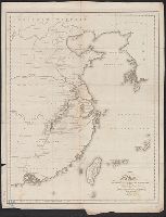
- Beinecke Rare Book and Manuscript Library > A map of the Route of the British Embassy, from the mouth of the Peiho River, to Pekin and from thence to Canton, in the year 1816.
- Creator:
- Cary, John, ca. 1754-1835
- Published / Created:
- Apr. 28, 1811.
- Call Number:
- 56 1811
- Container / Volume:
- BRBL_00685
- Image Count:
- 1
- Resource Type:
- Maps, Atlases & Globes
- Description:
- From Cary's new universal atlas ... London : Printed for J. Cary, 1808.
- Publisher:
- J. Cary,
- Subject (Geographic):
- China--Maps
- Subject (Name):
- Cary, John, ca. 1754-1835. Cary's new universal atlas
- Found in:
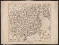
- Beinecke Rare Book and Manuscript Library > A new map of China, from the latest authorities / by John Cary, engraver.
- Creator:
- Cary, John, ca. 1754-1835
- Published / Created:
- Apr. 28, 1811.
- Call Number:
- 56 1811
- Container / Volume:
- BRBL_00295
- Image Count:
- 1
- Resource Type:
- Maps, Atlases & Globes
- Description:
- From Cary's new universal atlas ... London : Printed for J. Cary, 1808.
- Publisher:
- J. Cary,
- Subject (Geographic):
- China--Maps
- Subject (Name):
- Cary, John, ca. 1754-1835. Cary's new universal atlas
- Found in:
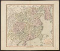
- Beinecke Rare Book and Manuscript Library > A new map of China, from the latest authorities / by John Cary, engraver.
- Creator:
- Rand McNally and Company
- Published / Created:
- c1901.
- Call Number:
- 56 1901A
- Container / Volume:
- BRBL_00296
- Image Count:
- 2
- Resource Type:
- Maps, Atlases & Globes
- Alternative Title:
- Four-track series., Map of Asia, and New map of Asia and the Chinese empire as they are to-day :
- Description:
- "Printed for the New York Central's 'Four-Track Series. No. 28'"
- Publisher:
- Rand, McNally & Co. ,
- Subject (Geographic):
- China--Maps, Japan--Maps, and Korea--Maps
- Subject (Name):
- New York Central and Hudson River Railroad Company
- Subject (Topic):
- Transportation--China--Maps, Transportation--Japan--Maps, and Transportation--Korea--Maps
- Found in:
- Beinecke Rare Book and Manuscript Library > A new map of the Chinese Empire with Japan and Korea. Map of Asia. / by Rand, McNally & Co.
- Creator:
- United States. Army Map Service
- Published / Created:
- 1944
- Call Number:
- 50 1945F
- Container / Volume:
- BRBL_00273
- Image Count:
- 2
- Resource Type:
- Maps, Atlases & Globes
- Abstract:
- Shows roads, boundaries, railroads, power transmission lines, cities, towns, rivers, marsh, open water areas.
- Alternative Title:
- AAF cloth map. and Asiatic series
- Description:
- "Officers using this chart will mark her
- Publisher:
- Army Map Service, U.S. Army,
- Subject (Geographic):
- China--Maps and Southeast Asia--Maps
- Subject (Name):
- United States. Aeronautical Chart Service and United States. Army Air Forces
- Subject (Topic):
- Military maps, Ocean currents--China--Maps, Ocean Currents--Southeast Asia--Maps, Winds--China--Maps, and Winds--Southeast Asia--Maps
- Found in:
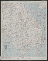
- Beinecke Rare Book and Manuscript Library > AAF cloth map. Asiatic series. French Indo China / compiled for the U.S. Army Air Forces by the Army Map Service.
- Creator:
- United States. Army Map Service
- Published / Created:
- 1945
- Call Number:
- 50 1945G
- Container / Volume:
- BRBL_00273
- Image Count:
- 2
- Resource Type:
- Maps, Atlases & Globes
- Abstract:
- Shows roads, boundaries, railroads, power transmission lines, cities, towns, rivers, marsh, open water areas.
- Alternative Title:
- AAF cloth map. and Asiatic series
- Description:
- "Officers using this chart will mark hereon corrections and additions which come t
- Publisher:
- Army Map Service, U.S. Army,
- Subject (Geographic):
- China--Maps and Southeast Asia--Maps
- Subject (Name):
- United States. Aeronautical Chart Service and United States. Army Air Forces
- Subject (Topic):
- Military maps, Ocean currents--China--Maps, Ocean Currents--Southeast Asia--Maps, Winds--China--Maps, and Winds--Southeast Asia--Maps
- Found in:
- Beinecke Rare Book and Manuscript Library > AAF cloth map. Asiatic series. French Indo China / compiled for the U.S. Army Air Forces by the Army Map Service.
- Creator:
- United States. Hydrographic Office
- Published / Created:
- 1904
- Call Number:
- 57 1904
- Container / Volume:
- BRBL_00302
- Image Count:
- 1
- Resource Type:
- Maps, Atlases & Globes
- Alternative Title:
- Charts, etc.
- Description:
- "No. 2156."
- Publisher:
- Hydrographic Office,
- Subject (Geographic):
- China--Maps, Japan--Maps, and Korea--Maps
- Found in:
- Beinecke Rare Book and Manuscript Library > Asia, Japan and Korea : with the surrounding seas and the adjacent coastal region of China / published at Washington, D.C. Feb. 1904, at the Hydrographic Office. H.M. Hodges, Lieutenant Commander, U.S.N. Hydrographer.
- Creator:
- United States. Hydrographic Office
- Published / Created:
- 1904
- Call Number:
- 556cea 1904
- Container / Volume:
- BRBL_00293
- Image Count:
- 1
- Resource Type:
- Maps, Atlases & Globes
- Alternative Title:
- Charts, etc.
- Description:
- "No. 2156."
- Publisher:
- Hydrographic Office,
- Subject (Geographic):
- China--Maps, Japan--Maps, and Korea--Maps
- Found in:
- Beinecke Rare Book and Manuscript Library > Asia, Japan and Korea : with the surrounding seas and the adjacent coastal region of China / published at Washington, D.C. Feb. 1904, at the Hydrographic Office. H.M. Hodges, Lieutenant Commander, U.S.N. Hydrographer.
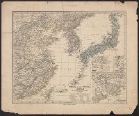
- Creator:
- Petermann, A. (August), 1822-1878
- Published / Created:
- 1877
- Call Number:
- 56 1877
- Container / Volume:
- BRBL_00296
- Image Count:
- 1
- Resource Type:
- Maps, Atlases & Globes
- Alternative Title:
- China (östlicheTheil), Korea und Japan im Massstab 1:7.500.000
- Description:
- From Stieler's Hand-Atlas.
- Publisher:
- Justus Perthes,
- Subject (Geographic):
- China--Maps, Japan--Maps, and Korea--Maps
- Subject (Name):
- Debes, E. (Ernst), 1840-1923
- Found in:
- Beinecke Rare Book and Manuscript Library > China (östl. Theil), Korea und Japan im Massstab 1:7.500.000 / von A. Petermann ; bearbeitet von Ernst Debes ; gestochen v. H. Eberhardt ; Terrain v. C. Jungmann.
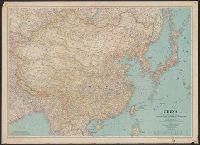
- Creator:
- National Geographic Society (U.S.). Cartographic Section
- Published / Created:
- 1945
- Call Number:
- 56 1945
- Container / Volume:
- BRBL_00296
- Image Count:
- 1
- Resource Type:
- Maps, Atlases & Globes
- Description:
- "June 1945."
- Publisher:
- Lithographed by A. Hoen and Co., and National Geographic Society ;
- Subject (Geographic):
- China--Maps
- Subject (Name):
- Darley, James M. (James Morrison)
- Found in:
- Beinecke Rare Book and Manuscript Library > China [cartographic material] / compiled and drawn in the Cartographic Section of the National Geographic Society for the National Geographic Magazine ; James M. Darley, chief cartographer.