Search
You Searched For
Search Results
- Published / Created:
- [1751?]
- Call Number:
- 56 1751
- Container / Volume:
- BRBL_00294
- Image Count:
- 1
- Resource Type:
- Maps, Atlases & Globes
- Subject (Geographic):
- China--Maps--Early works to 1800
- Found in:
- Beinecke Rare Book and Manuscript Library > L'Empire de la Chine ... Par le Sr. Robert de Vaugondy.
- Published / Created:
- 1751
- Call Number:
- 56 1751A
- Container / Volume:
- BRBL_00294
- Image Count:
- 1
- Resource Type:
- Maps, Atlases & Globes
- Subject (Geographic):
- China--Maps--Early works to 1800
- Found in:
- Beinecke Rare Book and Manuscript Library > L'Empire de la Chine dresse d'apres les Cartes de l'Atlas Chinois. Par le Sr. Robert de Vaugondy. Geographe ordinaire du Roi. Avec Privilege.
- Creator:
- Sanson, Nicolas, 1600-1667
- Published / Created:
- 1656
- Call Number:
- 56 1656
- Container / Volume:
- BRBL_00294
- Image Count:
- 1
- Resource Type:
- Maps, Atlases & Globes
- Alternative Title:
- Chine royavme
- Description:
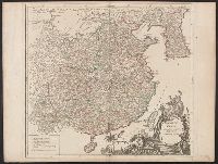
- From Sanson's Cartes générales de toutes les parties du monde (1658).
- Publisher:
- Chez Pierre Mariette, Rue S. Iacque a l'Esperance, avecq privilege du Roy pour vingt ans,
- Subject (Geographic):
- China--Maps--Early works to 1800
- Subject (Name):
- Mariette, Pierre, 1603-1657, Sanson, Nicolas, 1600-1667. Cartes générales de toutes les parties du monde, and Somer, Jan, engraver
- Found in:
- Beinecke Rare Book and Manuscript Library > La Chine royaume [cartographic material] : cette carte n'est quin abregé d'une autre tres belle, fort grande, et fort particuliere ... / par N. Sanson ; Johannes Somer Pruthenus sculpsit.
- Published / Created:
- [1750?]
- Call Number:
- 56 1750
- Container / Volume:
- BRBL_00294
- Image Count:
- 1
- Resource Type:
- Maps, Atlases & Globes
- Publisher:
- Homani anorum Heredum,
- Subject (Geographic):
- China--Maps--Early works to 1800
- Subject (Name):
- Homann Erben (Firm)
- Found in:
- Beinecke Rare Book and Manuscript Library > Regni Sin ae Vel Sinae Propriae ... R.P. du Halde et ab Anvillaeo Call: Reg: Geographo ... studio Joh: Math: Hasü, Math: P:P. ...
- Creator:
- Wit, Frederik de
- Call Number:
- 54 1684
- Container / Volume:
- BRBL_00290
- Image Count:
- 1
- Resource Type:
- Maps, Atlases & Globes
- Description:
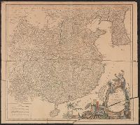
- Appears in N. Vischer's Atlas minor sive geographia compendiosa, 1684.
- Subject (Geographic):
- China--Maps--Early works to 1800, Japan--Maps--Early works to 1800, and Russia (Federation)--Maps--Early works to 1800
- Subject (Name):
- L'Huilier, Joannes, engraver and Visscher, Nicolaes, 1649-1702. Atlas minor
- Found in:
- Beinecke Rare Book and Manuscript Library > Tabula Tartariae et majoris partis regni Chinae / edita a F. de Wit ; Lhuilier fecit.
- Creator:
- Speed, John, 1552?-1629
- Published / Created:
- 1676?]
- Call Number:
- 56 1626
- Container / Volume:
- BRBL_00734
- Image Count:
- 2
- Resource Type:
- Maps, Atlases & Globes
- Description:
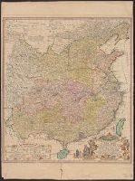
- "Are to be sold by Tho. Bassett in Fleet Street and Ric. Chiswell in St. P
- Publisher:
- Printed for Thomas Bassett and Richard Chiswell,
- Subject (Geographic):
- China--Maps--Early works to 1800
- Subject (Name):
- Bassett, Thomas, bookseller, Chiswell, Richard, and Speed, John, 1552?-1629. Theatre of the Empire of Great Britaine
- Found in:
- Beinecke Rare Book and Manuscript Library > The kingdome of China / newly augmented by I.S. 1626.
- Published / Created:
- [ca. 1625]
- Call Number:
- Pequot +P978
- Collection Title:
- Purchas his pilgrimes : In fiue bookes. The first, contayning the voyages and peregrinations made
- Image Count:
- 1
- Description:
- Bound in following p. 400.
- Subject (Geographic):
- America--Discovery and exploration--Early works to 1800 and China--Maps--Early works to 1800
- Subject (Topic):
- Geography--Early works to 1800, Religions--Early works to 1800, and Voyages and travels--Early works to 1800
- Collection Created:
- London :
- Found in:
- Beinecke Rare Book and Manuscript Library > The map of China