
You Searched For
1 - 7 of 7
Search Results

1. Photograph album of John Wesley Powell's Second Colorado River Expedition [graphic].
- Published / Created:
- 1871-1874.
- Call Number:
- WA Photos 54
- Image Count:
- 104
- Abstract:
- Photograph album of John Wesley Powell's Second Colorado River Expedition, containing photographs by E. O. Beaman, James Fennemore, and John K. Hillers. The first 118 photographs are attributed to Beaman, and depict the start of the expedition at the Green River Station in Wyoming, and the journey through the Red Canyon, Brown's Park, the Lodore Canyon, the Canyon of Desolation, the Cataract Canyon, and Salt Lake City, Utah, The next set of photographs in the album was probably taken by James Fennemore, showing views of Powell's expedition after his departure from Salt Lake City. They illustrate the journey from the mouth of the Dirty Devil River down through Glen Valley, Nevada, and Finally, there are several views of the Marble Canyon, the Grand Canyon, the Green River, the Virgin River, the Sevier River, Pine Creek, Kanab Creek, and a series of portraits by Hillers of Paiute, Ute and Pueblo Indians. Portraits of Hopi and Zuni Indians were probably taken by Beaman
- Description:
- Individual prints consist of 452 stereo-sized photographs, measuring 7.6 x 11.0 cm. or smaller, 52 larger photographs, measuring 18.5 x 10.9 cm. or smaller, and 5 photographs measuring 24.2 x 18.2 cm. or smaller. The photographs are generally not captioned. Attribution is based on secondary sources. and Insect damage to some pages, not affecting photographs.
- Subject (Geographic):
- Colorado River (Colo.-Mexico), Grand Canyon (Ariz.), United States, and Cataract Canyon Wilderness (Utah)
- Subject (Name):
- Powell, John Wesley, 1834-1902.
- Subject (Topic):
- Indians of North America, Hopi Indians, Zuni Indians, Paiute Indians, Ute Indians, and Exploring expeditions
- Found in:
- Beinecke Rare Book and Manuscript Library > Photograph album of John Wesley Powell's Second Colorado River Expedition [graphic].
2. Photographs of Arizona, Nevada, and Utah
- Creator:
- Geographical Surveys West of the 100th Meridian (U.S.)
- Published / Created:
- 1871-72.
- Call Number:
- WA Photos Folio 56
- Image Count:
- 13
- Abstract:
- Mounted photographs of Arizona, Nevada, and Utah created by Timothy H. O'Sullivan, with a single photographic print by William Bell, that document the Geographical Surveys West of the 100th Meridian led by George Montague Wheeler for the United States War Department, 1871-1872. O'Sullivan created photographs from the 1871 expedition, and Bell created photographs from the 1872 expedition. Manuscript captions pasted on versos of mounts describe geological formations in detail, and are signed "G.K.G" (Grove Karl Gilbert), geologist with the Wheeler expedition 1871-1874, Photographs by O'Sullivan depict several locations along the Colorado River in the Black Canyon and the Grand Canyon. Photographs of Nevada include a view of men and women in the mining town of Logan and a view of eroded strata near Cottonwood Springs. A photograph of Utah consists of a detailed view of a rock marked with striations from wind erosion near Grand Wash, Utah (misidentified by a typescript caption as below Fortification Rock, Arizona)., The photograph by Bell shows the Colorado River and Marble Canyon (identified as Grand Cañon) near the confluence with the Paria River in Arizona, and Accompanied by an architectural detail drawing with graphical representations of a scarab, dagger, celestial symbols, and a horned toad or rodent, as well as manuscript passage attributed to Pliny the Elder
- Description:
- Accompanied by a box list., Title devised by cataloger., Each photograph mounted on board with a descriptive letter-press captions: War Department, Corps of Engineers, U.S. Army. Expeditions West of the 100th Meridian ... Lt. Geo. M. Wheeler, Com'd'g., with title, series and number of image., and Numbers inscribed in some negatives.
- Subject (Geographic):
- Arizona, Black Canyon (Ariz. and Nev.), Colorado River (Colo.-Mexico), Grand Canyon (Ariz.), Logan (Nev.), Marble Canyon (Coconino County, Ariz. : Canyon), Nevada, Paria River (Utah and Ariz.), United States, and Utah
- Subject (Name):
- Bell, William, 1830-1910., Gilbert, Grove Karl, 1843-1918., O'Sullivan, Timothy H., 1840-1882, Wheeler, George M. 1842-1905. (George Montague),, Geographical Surveys West of the 100th Meridian (U.S.), and United States. War Department.
- Subject (Topic):
- Architecture, Details, Exploring expeditions, and Surveys
- Found in:
- Beinecke Rare Book and Manuscript Library > Photographs of Arizona, Nevada, and Utah
3. Photographs of southwestern states
- Creator:
- Bonawit, G. Owen (George Owen), 1891-1971
- Published / Created:
- 1944-1961.
- Call Number:
- WA Photos 414
- Container / Volume:
- Box 2
- Image Count:
- 1
- Abstract:
- Photographs created by G. Owen Bonawit that document locations in southwestern states, primarily Arizona and California, 1944-1961. Images along the Colorado River between Arizona and California include many images of the Parker Dam that depict the dam, substations, transmission lines, and men working on turbines, while additional images along the river include a view of big horn sheep by another photographer, Howard Fink. Images of Arizona include views in the Salt River Valley in the vicinity of Phoenix, the Naval Air Facility in Litchfield Park, and the operations of the Goodyear Tire and Rubber Company. Several photographic prints of the same image depicts an abandoned ranch in New Mexico and Images in the collection unrelated to southwestern states include views of locations in New York City, New York, consisting of artifacts at the Metropolitan Museum of Art and stained glass windows created by Bonawit at the Carmelite Monastery in Brooklyn
- Description:
- G. Owen Bonawit (1891-1971) was an artist who created stained glass decorations for religious and public buildings, as well as a photographer for the United States Bureau of Reclamation. and Title devised by cataloger.
- Subject (Geographic):
- United States, Arizona, California, Colorado River (Colo.-Mexico), Naval Air Facility (Ariz.), New Mexico, Parker Dam (Ariz. and Calif.), and Southwestern States
- Subject (Name):
- Bonawit, G. Owen 1891-1971. (George Owen),, Fink, Howard., Goodyear Tire and Rubber Company, and Metropolitan Museum of Art (New York, N.Y.)
- Subject (Topic):
- Dams, Glass painting and staining, Hydroelectric power plants, and Water-power
- Found in:
- Beinecke Rare Book and Manuscript Library > Photographs of southwestern states
4. Photographs showing landscapes, geological and other features, of portions of the western territory of the United States : obtained in connection with geographical and geological explorations and surveys west of the 100th meridian, seasons of 1871, 1872, and 1873
- Creator:
- Geographical Surveys West of the 100th Meridian (U.S.)
- Published / Created:
- 1871-1874.
- Call Number:
- WA Photos Folio 55
- Image Count:
- 68
- Abstract:
- Album of mounted photographic prints created by Timothy H. O'Sullivan and William Bell, and later compiled by the United States War Department. Photographs document the Geographical Surveys West of the 100th Meridian led by George Montague Wheeler, 1871-1873, The photographic prints were arranged into three consecutive series by the United States War Department, "Explorations in Nevada and Arizona - Expedition of 1871," with photographs by O'Sullivan; "Explorations & Surveys West of the 100th Meridian - Expedition of 1872," with photographs by Bell; and "Geographical & Geological Explorations West of the 100th Meridian - Expedition of 1873," with photographs by O'Sullivan, Images of the expedition of 1871 by O'Sullivan include locations along the Colorado River in the Black Canyon, Iceberg Canyon, and Grand Canyon between Arizona and Nevada. Other images include a view of men and women in the mining town of Logan, Nevada; a view of Saguaro cacti, probably in the upper Sonoran desert in southern Arizona; a detailed view of a rock marked with striations from wind erosion near Grand Wash, Utah (misidentified by a typescript caption as below Fortification Rock, Arizona); and a view of an alpine lake, in the Sierra Nevada mountains in California, Images of the expedition of 1872 by Bell include views of steep rock walls and narrow valleys in vicinity of Kanab Canyon, Arizona, as well as views of the Colorado River and Marble Canyon (identified as Grand Cañon) near the confluence with the Paria River in Arizona. Other images include a view of geologic rock formations in Salt Creek Canyon, Utah, and Perched Rock near Rocker Creek, Arizona, Images of the expedition of 1873 by O'Sullivan in Arizona include views in the vicinity of the White Mountains with several views of Apache Lake, including an image that shows Western Apache Indian military scouts, as well as a view of the ranch owned by Corydon Eliphalet Cooley. Several images in the vicinity of Canyon de Chelly include views of the White House and Anasazi ruins, as well as images of rock towers and canyon walls. Other images include a view at the confluence of the Colorado River and Paria River; a view of the North Fork Canyon and the White River (identified as Sierra Blanca Creek); and an overview of Fort Apache, Images of the expedition of 1873 by O'Sullivan in New Mexico include images related to Inscription Rock, with a view of the steep rock spires and detail photographs of Spanish inscriptions carved in sandstone. Images of the community of Zuni, include a view of the Nuestra Señora de Guadalupe mission church, as well as views of multi-story stone and adobe pueblos. An image shows a view of an entrance or narthex of the Mission of San Miguel in Santa Fe. An informal portrait near Fort Defiance shows Navajo men and women sitting and standing beside a loom, and An incidental image from the expedition of 1873 by O'Sullivan in Utah shows a view of mesa tops and canyon walls near the confluence of the San Juan River and the Colorado River
- Description:
- Copy of album in WA MSS S-744 described in finding aid for collection., Each photograph accompanied by guard sheet with descriptive letter-press. Letterpress captions on mounts: War Department Corps of engineers. U.S. army . . . Lieut. Geo. M. Wheeler, Com'd'g., and Photographs by Timothy O'Sullivan for the 1871 expedition to Nevada and Arizona, numbered 1 through 16; photographs by William Bell for the 1872 expedition along the Colorado River and the Grand Canyon, numbered 1 through 15; and photographs by O'Sullivan for the 1873 expedition to Arizona and New Mexico, numbered 1 through 19.
- Subject (Geographic):
- Apache Lake (Ariz.), Arizona, Black Canyon (Ariz. and Nev.), Bull Run Mountains (Nev.), Canyon de Chelly National Monument (Ariz.), Colorado River (Colo.-Mexico), El Morro National Monument (N.M.), Fort Apache (Ariz.), Fort Defiance (N.M.), Grand Canyon (Ariz.), Iceberg Canyon (Ariz. and Nev.), Inscription Rock (N.M.), Kanab Canyon (Ariz.), Logan (Nev.), Marble Canyon (Coconino County, Ariz. : Canyon), Nevada, New Mexico, North Fork Canyon (Ariz.), Paria River (Utah and Ariz.), Salt Creek Canyon (Utah), San Juan River (Colo.-Utah), Sierra Nevada (Calif. and Nev.), Southwest, New, United States, Utah, West (U.S.), White Mountains (Ariz.), White River (Nev.), and Zuni (N.M.)
- Subject (Name):
- Bell, William, 1830-1910., Cooley, Corydon Eliphalet, O'Sullivan, Timothy H., 1840-1882, Mission San Miguel (Santa Fe, N.M.), Nuestra Señora de Guadalupe (Mission : Zuni, N.M.), Geographical Surveys West of the 100th Meridian (U.S.), and United States. War Department.
- Subject (Topic):
- Homes & haunts, Indians of North America, Navajo Indians, Paiute Indians, Pueblo Indians, Pueblos, Saguaro, Western Apache Indians, Exploring expeditions, and Surveys
- Found in:
- Beinecke Rare Book and Manuscript Library > Photographs showing landscapes, geological and other features, of portions of the western territory of the United States : obtained in connection with geographical and geological explorations and surveys west of the 100th meridian, seasons of 1871, 1872, and 1873
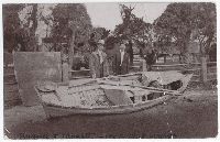
5. Postcard of Edwin R. Monett and Charles Russell with the open boat they used to run the Colorado river from Utah to California in 1907 and 1908
- Published / Created:
- [1910]
- Call Number:
- BrSide4o Zc56 910jo
- Image Count:
- 1
- Resource Type:
- still image and text
- Abstract:
- Postcard shows Edwin R. Monett and Charles Russell with the open 16-foot wooden boat they used to run the Colorado from Green River, Utah to Needles, California between September 20, 1907 and February 8, 1908
- Alternative Title:
- Russell & Monett 1907-1908 voyage
- Description:
- BEIN BrSide4o Zc56 910Jo: In handwriting on recto at bottom of card: Russell & Monett 1907-1908 voyage. Verso of postcard filled out with address, note, and signature. Postmarked "Grand Canyon, Nov. 12 1910, Ariz." and Printed on verso: Tom Jones--glacé--Cincinnati, O. Published by Fred Harvey. Russell and Monett. Two prospectors after their 752 mile voyage through the Grand Canyon. They started from Green River, Utah, September 20th, arriving at Neddles, Calif., February 8th.
- Publisher:
- Tom Jones, published by Fred Harvey
- Subject (Geographic):
- Colorado River (Colo.-Mexico)
- Subject (Name):
- Russell, Charles S. and Monett, Edwin R.
- Subject (Topic):
- Prospecting and Description and travel
- Found in:
- Beinecke Rare Book and Manuscript Library > Postcard of Edwin R. Monett and Charles Russell with the open boat they used to run the Colorado river from Utah to California in 1907 and 1908
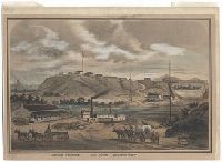
6. Southern California, Fort Yuma, Colorado River
- Published / Created:
- [not before 1877]
- Call Number:
- BrSides Zc72 877so
- Image Count:
- 1
- Resource Type:
- still image and text
- Abstract:
- Print shows a view of Fort Yuma from across the Colorado River; the Sourthern Pacific railway trestle (built 1877) crosses the river to the right, in the middle ground; the Fort is on the hill top, in center; mule-drawn wagons in foreground; steamboat, ferry, and warehouse in center; cloudy sky in upper half of image; double-line border frames image
- Description:
- BEIN Broadsides Zc72 877so: On sheet 21.8 x 31.7 cm, mounted on sheet 23.1 x 32.5 cm. and Title from caption below image.
- Publisher:
- publisher not identified
- Subject (Geographic):
- Fort Yuma (Calif.) and Colorado River (Colo.-Mexico)
- Subject (Name):
- Southern Pacific Railroad Company
- Found in:
- Beinecke Rare Book and Manuscript Library > Southern California, Fort Yuma, Colorado River

7. The Rocky Mountains. No. 25
- Creator:
- Ingersoll, Ernest, 1852-1946
Jackson, William Henry, 1843-1942 - Call Number:
- ZZc49 889ph
- Collection Title:
- Photographs of Colorado
- Image Count:
- 1
- Abstract:
- Photographs mounted on cardboard leaves. Extensive manuscript annotations and many direct quotes from Ernest Ingersolls "Crest of the Continent" on rectos.
- Description:
- Ingersoll traveled with the U.S.G.S. in Colorado in 1874.
- Subject (Geographic):
- Colorado River (Colo.-Mexico) and Colorado.
- Subject (Topic):
- Canyons., Landscape photography., and Rivers
- Collection Created:
- 1889
- Found in:
- Beinecke Rare Book and Manuscript Library > The Rocky Mountains. No. 25