Search
You Searched For
Search Results
- Published / Created:
- 1916
- Call Number:
- 304ed 1916
- Container / Volume:
- BRBL_00034A
- Image Count:
- 1
- Resource Type:
- Maps, Atlases & Globes
- Alternative Title:
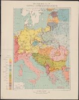
- Central and South Eastern Europe.
- Description:
- "G.S., G.S., no. 2824."
- Publisher:
- Drawn and printed at the War Office,
- Subject (Geographic):
- Europe, Central--Maps
- Subject (Name):
- Geological Survey (U.S.)
- Found in:
- Beinecke Rare Book and Manuscript Library > Ethnographical Map of Central & South Eastern Europe.
- Creator:
- Geological Survey (U.S.)
- Published / Created:
- 1916
- Call Number:
- 304ed 1916
- Container / Volume:
- BRBL_00034A
- Image Count:
- 1
- Resource Type:
- Maps, Atlases & Globes
- Alternative Title:
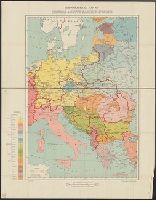
- Central and South Eastern Europe.
- Description:
- "G.S., G.S., no. 2824."
- Publisher:
- Drawn and printed at the War Office,
- Subject (Geographic):
- Europe, Central--Maps
- Found in:
- Beinecke Rare Book and Manuscript Library > Ethnographical Map of Central & South Eastern Europe.
- Published / Created:
- [1875?]
- Call Number:
- 304 1875
- Container / Volume:
- BRBL_00034
- Image Count:
- 1
- Resource Type:
- Maps, Atlases & Globes
- Publisher:
- Lanée Seur de Longuet,
- Subject (Geographic):
- Europe, Central--Maps
- Found in:
- Beinecke Rare Book and Manuscript Library > Europe Centrale.
- Creator:
- Handtke, F. (Friedrich), 1815-1879
- Published / Created:
- [1867?].
- Call Number:
- 304 1867
- Container / Volume:
- BRBL_00033
- Image Count:
- 1
- Resource Type:
- Maps, Atlases & Globes
- Description:
- 304 1867: Hand col. and No. 36 and No. 37.
- Publisher:
- Flemming,
- Subject (Geographic):
- Europe, Central--Maps
- Found in:
- Beinecke Rare Book and Manuscript Library > F. Handtke's Special-Karte von Mittel-Europa / F. Handtke.
- Published / Created:
- [1945?]
- Call Number:
- 50 1945J
- Container / Volume:
- BRBL_00273
- Image Count:
- 2
- Resource Type:
- Maps, Atlases & Globes
- Alternative Title:
- [Map of Central Europe]
- Description:
- Cloth map.
- Publisher:
- Air Ministry,
- Subject (Geographic):
- Europe, Central--Maps and France--Maps
- Found in:
- Beinecke Rare Book and Manuscript Library > France.
- Published / Created:
- 1915
- Call Number:
- 304f 1915
- Container / Volume:
- BRBL_00034A
- Image Count:
- 1
- Resource Type:
- Maps, Atlases & Globes
- Publisher:
- dell' Editore Antonio Vallardi,
- Subject (Geographic):
- Europe, Central--Maps
- Found in:
- Beinecke Rare Book and Manuscript Library > Frontiera Italo-Austriaca e Territori della "Piu Grande Italia".
- Published / Created:
- 1876
- Call Number:
- 41 K14 1876
- Container / Volume:
- BRBL_00242
- Image Count:
- 4
- Resource Type:
- Maps, Atlases & Globes
- Description:
- Tables of various data in margins.
- Publisher:
- K.K. Militaerischen Geografischen Institute,
- Subject (Geographic):
- Europe, Central--Maps
- Found in:
- Beinecke Rare Book and Manuscript Library > General Karte der Herzogthümer Kärnten und Krain, der Gefürsteten Grafschaft Görz und Gradiska, der Markgrafschaft Istrien, der reichsunmittelbaren Stadt Triest sammt ihrem Gebiete und des königlich ungarischen Küstenlandes.
- Creator:
- United States. Office of Strategic Services. Research and Analysis Branch
- Published / Created:
- 1943
- Call Number:
- 36cb 1943
- Container / Volume:
- BRBL_00127
- Image Count:
- 1
- Resource Type:
- Maps, Atlases & Globes
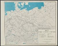
- Alternative Title:
- Germany, terrain and selected railroads.
- Description:
- "Map no. 2905, 21 December 1943.", "Reliability code: 1B-1A-2.", and Relief shown by gradient tints.
- Publisher:
- Lithographed in the Reproduction Branch, OSS,
- Subject (Geographic):
- Europe, Central--Maps and Germany--Maps
- Subject (Topic):
- Railroads--Europe, Central--Maps and Railroads--Germany--Maps
- Found in:
- Beinecke Rare Book and Manuscript Library > Germany, terrain & selected railroads / compiled and drawn in the Branch of Research and Analysis, OSS.
- Creator:
- United States. Office of Strategic Services. Research and Analysis Branch
- Published / Created:
- 1943
- Call Number:
- 36cb 1943
- Container / Volume:
- BRBL_00127
- Image Count:
- 1
- Resource Type:
- Maps, Atlases & Globes
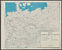
- Alternative Title:
- Germany, terrain and selected railroads.
- Description:
- "Map no. 2905, 21 December 1943.", "Reliability code: 1B-1A-2.", and Relief shown by gradient tints.
- Publisher:
- Lithographed in the Reproduction Branch, OSS,
- Subject (Geographic):
- Europe, Central--Maps and Germany--Maps
- Subject (Topic):
- Railroads--Europe, Central--Maps and Railroads--Germany--Maps
- Found in:
- Beinecke Rare Book and Manuscript Library > Germany, terrain & selected railroads / compiled and drawn in the Branch of Research and Analysis, OSS.