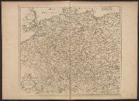
Preliminary record. and The map (bounded by Frisia, Jutland, Prussia, Poland and extending South to include Silesia and parts of Bavaria and Lotharingia) occupies the upper half of the sheet; the lower half shows an engraved battle scence ...
Inset illustration of the Reichstag of Holy Roman Empire, with title: The General Diet of the Empire, or it's Parliament.
Subject (Geographic):
Europe, Central--Maps--Early works to 1800, Germany--Maps--Early works to 1800, Hungary--Maps--Early works to 1800, Romania--Maps--Early works to 1800, and Switzerland--Maps--Early works to 1800
Subject (Name):
Holy Roman Empire.--Reichstag and Hughes, Thomas Lowe,--1925---Ownership
Delarochette, L. (Louis), 1731-1802 Kitchin, Thomas, 1718-1784. New universal atlas. 1804 Laurie & Whittle
Call Number:
36 1794B
Container / Volume:
BRBL_00119
Image Count:
2
Resource Type:
Maps, Atlases & Globes
Description:
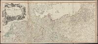
Appeared in Kitchin's New universal atlas, 6th ed., 1804., In ms. on verso: No. 27., Relief shown pictorially., and The circles of Westphalia and Lower Saxony, with the western parts of the Circle of Upper Saxony, and the northern parts of the
Subject (Geographic):
Austria--Maps--Early works to 1800, Europe, Central--Maps--Early works to 1800, and Germany--Maps--Early works to 1800
Preliminary record. and Route to Turin & Milan, Genoa, Florence, Rome, Naples, and the South of Italy ca. 1:2,000,000, margin of map. Rhine from Dusseldorf to Mayence ca. 1:380,160. Route of the Simplon ca. 1:200,000.
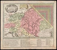
"Cum gratia et privil. S.R.I. Vicariatus, in partib[us] Rheni, Suevice, et Juris Franconici.", Covers Austria, Slovakia, Hungary, Transylvania, Slovenia and Croatia., Includes also ists of Jesuits active in the Austrian Empire., Includes table of distances given in hours of travel between individual locations., Manuscript number in upper right corner: 12. From the Karpinski-von Wieser Map Collection., and Relief shown pictorially.
Publisher:
M. Seutter
Subject (Geographic):
Europe, Central--Maps--Early works to 1800
Subject (Name):
Jesuits--Europe, Central--Maps--Early works to 1800 and Mayr, Johann Baptist, 1634-1708
Bar scales given in "mille pas géometriques," "lieues de Hongrie," and "lieues communes d'Allemagne"., Prime meridian: Ferro., Relief shown pictorially., Stamp on verso: 78. Sheet measures 50.5 x 66.6 cm., and Variant with "ordinaire du Roi," privilege statement
Publisher:
Gilles Robert de Vaugondy?,
Subject (Geographic):
Balkan Peninsula--Maps--Early works to 1800, Europe, Central--Maps--Early works to 1800, and Hungary--Maps--Early works to 1800