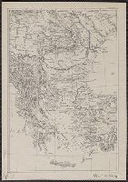
BEIN Series 304 1886A: Imperfect: all sheets but C2-4, D2-4, E2-4 wanting., In upper margin of some maps: Domborzati áttekintés., Maps individually numbered and subtitled in upper margin, e.g.: B.4. Pola, Zara, Comacchio -- C2. Brno -- D.2. Kassa és Kraków -- E3. Koloszvár -- F.3. Bielcy, Kisziniew, Jassi., Publisher's name in lower margin differs: M. Kir. Térképészeti Intézet -- M. Kir. Állami Térképészeti Intézet -- M. Kir. Állami Térképészet -- M.kir. állami térképészet nyomása., Subtitles for the same map may differ according to ed., Title devised by cataloger., and Various eds. of some maps.
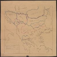
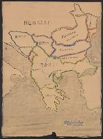
Legend indicates boundaries according to San Stefano in pink crayon, and boundaries according to Berlin in blue crayon. and Title supplied by cataloger.
Publisher:
s.n.,
Subject (Geographic):
Balkan Peninsula--Maps and Europe, Eastern--Maps
Subject (Topic):
Boundaries--Balkan Peninsula--Russo-Turkish War, 1877-1878 and Boundaries--Europe, Eastern--Russo-Turkish War, 1877-1878
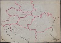
Map includes historical regions of Eastern Roumelia, Dobruja, and Bessarabia. Borders drawn in black ink, countries outlined in crayon. and Title supplied by cataloger.
Publisher:
s.n.,
Subject (Geographic):
Balkan Peninsula--Maps and Europe, Eastern--Maps
Subject (Topic):
Boundaries--Balkan Peninsula--Maps and Boundaries--Europe, Eastern--Maps