1.

- Published / Created:
- 1870
- Call Number:
- 30 1870F
- Container / Volume:
- BRBL_00032
- Image Count:
- 1
- Resource Type:
- Maps, Atlases & Globes
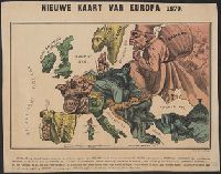
- Description:
- Caricature map., Ill. of people and animals represent international relations., In top margin: Voorwaarts., and Includes text.
- Publisher:
- W.L. Stoeller,
- Subject (Geographic):
- Europe--Maps
- Subject (Topic):
- Franco-Prussian War, 1870-1871--Caricatures and cartoons, Franco-Prussian War, 1870-1871--Maps, and International relations--History--19th century--Maps
- Found in:
- Beinecke Rare Book and Manuscript Library > Kaart der oneenige staten van Europa.