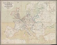
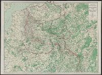
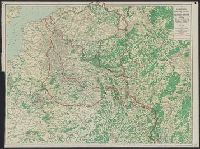
Carl Flemming (Firm) Flemming, C. (Carl), 1806-1878 Kettler, J. I
Published / Created:
[1918?]
Call Number:
11hc 1918P
Container / Volume:
BRBL_00010F
Image Count:
1
Resource Type:
Maps, Atlases & Globes
Description:
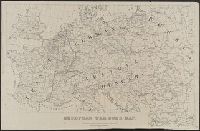
"Redigiert von Prof. Dr. J.I. Kettler"--Bottom left corner of Nordhälfte map., [1], [2], 11hc 1918P: Imperfect: First sheet (Nordhälfte) only., Nordhälfte (Paris und Umgebung bis zur Nordsee) --, Relief shown by shading., Sho, and Südhälfte (Reims bis Belfort).
Publisher:
Carl Flemming AG.,
Subject (Geographic):
Belgium--Maps, Europe--Maps, and France--Maps
Subject (Topic):
World War, 1914-1918--Belgium--Maps, World War, 1914-1918--Europe--Maps, and World War, 1914-1918--France--Maps
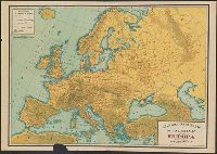
Haberlandt, Arthur, b. 1889 Kartographische Anstalt Freytag und Berndt
Published / Created:
[1915?]
Call Number:
30ed 1915
Container / Volume:
BRBL_00037B
Image Count:
2
Resource Type:
Maps, Atlases & Globes
Alternative Title:
G. Freytag's Karte von Europa and Völkerkarte von Europa
Description:
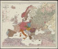
Shows areas of ocean under British, Russian, French and Italian control: "Sperrgebiet um England, Russland, Frankreich und Italien." and Shows old and new borders and the languages spoken within those regions.
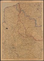
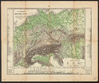
Indicates "Furthest advance of the German Army", and "Battle line May 10th, 1918" overprinted in red., Relief shown by spot heights., and Shows railways, canals, aircraft depots, wireless stations, forts, naval arsenals and boundaries.
Publisher:
C.S. Hammond,
Subject (Geographic):
Europe--Maps
Subject (Topic):
World War, 1914-1918--Campaigns--Europe--Maps and World War, 1914-1918--Campaigns--Western Front--Maps