Search
You Searched For
Search Results
- Creator:
- Bellin, Jacques Nicolas, 1703-1772
- Published / Created:
- 1764
- Call Number:
- 85 1764
- Container / Volume:
- BRBL_00693
- Image Count:
- 1
- Resource Type:
- Maps, Atlases & Globes
- Description:
- "No. 66" in upper right corner.
- Publisher:
- s.n.],
- Subject (Geographic):
- Gulf Coast (Fla.)--Maps--Early works to 1800
- Subject (Name):
- France. Dépôt des cartes et plans de la marine
- Subject (Topic):
- Coasts--Gulf States--Maps--Early works to 1800 and Coasts--Louisiana--Maps--Early works to 1800
- Found in:
- Beinecke Rare Book and Manuscript Library > Carte reduite des costes de la Louisiane et de la Floride / [cartographic material] / dressée au Dépost des cartes, plans et journaux de la Marine pour le service des vaisseaux du roy par ordre de M. Le Duc de Choisel, colonel général des Suisses et G
- Creator:
- Jefferys, Thomas, -1771, cartographer
- Published / Created:
- 20 Feby. 1775.
- Call Number:
- 792cea 1775B
- Container / Volume:
- BRBL_00730
- Image Count:
- 1
- Resource Type:
- Maps, Atlases & Globes
- Alternative Title:
- Peninsula and Gulf of Florida or Channel of Bahama with the Bahama Islands
- Description:
- "DG.4."
- Publisher:
- Printed for Robt. Sayer, map and printseller ...,
- Subject (Geographic):
- Bahamas--Maps--Early works to 1800, Gulf Coast (Fla.)--Maps--Early works to 1800, and Gulf Coast (La.)--Maps--Early works to 1800
- Subject (Name):
- Jefferys, Thomas, d. 1771. American atlas and Sayer, Robert, 1725-1794
- Found in:
- Beinecke Rare Book and Manuscript Library > The coast of West Florida and Louisiana : the Peninsula and Gulf of Florida or Channel of Bahama with the Bahama Islands / by Thos. Jefferys ...
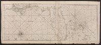
- Creator:
- Jefferys, Thomas, -1771, cartographer
- Published / Created:
- 20 Feby. 1775.
- Call Number:
- 792cea 1775A
- Container / Volume:
- BRBL_00691
- Image Count:
- 1
- Resource Type:
- Maps, Atlases & Globes
- Alternative Title:
- Peninsula and Gulf of Florida or Channel of Bahama with the Bahama Islands
- Description:
- "DG.4."
- Publisher:
- Printed for Robt. Sayer, map and printseller ...,
- Subject (Geographic):
- Bahamas--Maps--Early works to 1800, Gulf Coast (Fla.)--Maps--Early works to 1800, and Gulf Coast (La.)--Maps--Early works to 1800
- Subject (Name):
- Jefferys, Thomas, d. 1771. American atlas and Sayer, Robert, 1725-1794
- Found in:
- Beinecke Rare Book and Manuscript Library > The coast of West Florida and Louisiana : the Peninsula and Gulf of Florida or Channel of Bahama with the Bahama Islands / by Thos. Jefferys ...
- Creator:
- Jefferys, Thomas, d. 1771
- Published / Created:
- 20 Feby. 1775.
- Call Number:
- 792cea 1775
- Container / Volume:
- BRBL_00519
- Image Count:
- 1
- Resource Type:
- Maps, Atlases & Globes
- Alternative Title:
- Peninsula and Gulf of Florida or Channel of Bahama with the Bahama Islands.
- Description:
- From Jefferys's The American atlas ... London : Printed and sold by R. Sayer and J. Bennett, 1776.
- Publisher:
- Printed for Robt. Sayer, map and printseller ...,
- Subject (Geographic):
- Bahamas--Maps--Early works to 1800, Gulf Coast (Fla.)--Maps--Early works to 1800, and Gulf Coast (La.)--Maps--Early works to 1800
- Subject (Name):
- Jefferys, Thomas, d. 1771. American atlas and Sayer, Robert, 1725-1794
- Found in:
- Beinecke Rare Book and Manuscript Library > The coast of West Florida and Louisiana [cartographic material] : the Peninsula and Gulf of Florida or Channel of Bahama with the Bahama Islands / by Thos. Jefferys ...