Skip to search
Skip to main content
Skip to first result
Search
You Searched For
Subject (Geographic)
Indian Territory--Maps
Search Results
Published / Created:
1900?]
Call Number:
827ed C861 1900
Container / Volume:
BRBL_00578
Image Count:
1
Resource Type:
Maps, Atlases & Globes
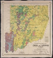
Description:
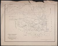
"Ricksecker, Hockbusch and Patton, civil engineers, Muskogee, I.T."
Publisher:
Bradley Real Estate Co.?,
Subject (Geographic):
Indian Territory--Maps
Subject (Name):
Hall Lithographing Co and Ricksecker, Hockbusch & Patton
Subject (Topic):
Railroads--Indian Territory--Maps
Found in:
Beinecke Rare Book and Manuscript Library > Classification map of Creek and Seminole nations / prepared for the Bradley Real Estate Co.
Published / Created:
[between 1900 and 1907?]
Call Number:
826 1900
Container / Volume:
BRBL_00577
Image Count:
1
Resource Type:
Maps, Atlases & Globes
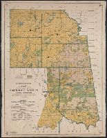
Description:
"Ricksecker, Hockbusch & Patton, civil engineers, Muskogee, I.T."
Publisher:
Aug. Gast Bank Note & Litho. Company,
Subject (Geographic):
Indian Territory--Maps
Subject (Name):
August Gast Bank Note & Lithographing Company and Ricksecker, Hockbusch & Patton
Subject (Topic):
Railroads--Indian Territory--Maps
Found in:
Beinecke Rare Book and Manuscript Library > Classification map of the Cherokee Nation, Indian Territory : compiled from official records of the United States Geological Survey / prepared for the Bradley Realty Bank and Trust Co.
Published / Created:
[between 1900 and 1907?]
Call Number:
827ed C424 1900
Container / Volume:
BRBL_00578
Image Count:
1
Resource Type:
Maps, Atlases & Globes
Description:
"Ricksecker, Hockbusch & Patton, civil engineers, Muskogee, I.T."
Publisher:
Aug. Gast Bank Note & Litho. Company,
Subject (Geographic):
Indian Territory--Maps
Subject (Name):
August Gast Bank Note & Lithographing Company and Ricksecker, Hockbusch & Patton
Subject (Topic):
Railroads--Indian Territory--Maps
Found in:
Beinecke Rare Book and Manuscript Library > Classification map of the Cherokee Nation, Indian Territory : compiled from official records of the United States Geological Survey / prepared for the Bradley Realty Bank and Trust Co.
Creator:
Published / Created:
1877
Call Number:
796 1877A
Container / Volume:
BRBL_00526
Image Count:
3
Resource Type:
Maps, Atlases & Globes
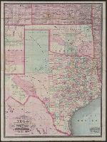
Alternative Title:
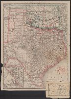
New county and railroad map of Texas and Indian Territory and New railroad and township map of Texas and Indian Territ'y
Description:
"Entered according to act of Congress in the year 1873 by G.F. Cram in the office of the librarian of Congress at Washington, D.C."
Publisher:
George F. Cram,
Subject (Geographic):
Indian Territory--Maps, Texas--Administrative and political divisions--Maps, and Texas--Maps
Subject (Topic):
Railroads--Indian Territory--Maps and Railroads--Texas--Maps
Found in:
Beinecke Rare Book and Manuscript Library > Cram's new county and railroad map of Texas and Indian Territory : showing latest government surveys &c &c / Geo. F. Cram, lith.
Creator:
Published / Created:
1879
Call Number:
826 1879
Container / Volume:
BRBL_00577
Image Count:
1
Resource Type:
Maps, Atlases & Globes
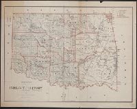
Description:
Includes dates of treaties with Indian nations.
Publisher:
General Land Office,
Subject (Geographic):
Indian Territory--Maps
Subject (Name):
Roeser, C. (Charles)
Found in:
Beinecke Rare Book and Manuscript Library > Indian Territory, 1879 / compiled from the official records of the General Land Office and other sources by C. Roeser, Principal Draughtsman.
Published / Created:
[1867?]
Call Number:
826 1866
Container / Volume:
BRBL_00577
Image Count:
1
Resource Type:
Maps, Atlases & Globes
Description:
"Prepared from the map of Daniel C. Major ... and from Lieut. Col. J.E. Johnston's Map of the southern boundary of Kansas in 1857. [And from] the Map of the Creek country by Lieut. I.C. Woodruff, Topl. Engrs., in 1850-51."
Publisher:
Engineer Bureau War Dept.,
Subject (Geographic):
Indian Territory--Maps
Subject (Name):
Johnston, Joseph E. (Joseph Eggleston), 1807-1891, Major, Daniel C, United States. War Dept. Engineer Bureau, and Woodruff, I. C
Subject (Topic):
Indians of North America--Maps
Found in:
Beinecke Rare Book and Manuscript Library > Indian territory with part of the adjoining state of Kansas &c. / Engineer Bureau War Dept., October 1866.
Creator:
Published / Created:
1890
Call Number:
826 1890
Container / Volume:
BRBL_00577
Image Count:
1
Resource Type:
Maps, Atlases & Globes
Description:
In upper left margin: Eleventh Census of the United States.
Publisher:
The Bureau,
Subject (Geographic):
Indian Territory--Maps and Oklahoma--Maps
Subject (Name):
Julius Bien & Co
Found in:
Beinecke Rare Book and Manuscript Library > Map of Indian Territory and Oklahoma.
Creator:
Published / Created:
1886
Call Number:
796 1886A
Container / Volume:
BRBL_00526
Image Count:
1
Resource Type:
Maps, Atlases & Globes
Alternative Title:
Rand, McNally & Co.'s Texas and Indian Territory and Texas and the Indian Territory
Description:
Includes map of western portion of Texas.
Publisher:
Rand, McNally & Co.,
Subject (Geographic):
Indian Territory--Maps, Texas--Administrative and political divisions--Maps, and Texas--Maps
Subject (Topic):
Railroads--Indian Territory--Maps, Railroads--Texas--Denison--Maps, and Railroads--Texas--Maps
Found in:
Beinecke Rare Book and Manuscript Library > Map of Texas and the Indian Territory.
Creator:
Published / Created:
1874
Call Number:
796 1874B
Container / Volume:
BRBL_00526
Image Count:
1
Resource Type:
Maps, Atlases & Globes
Description:
"From the Streeter collection."
Publisher:
Askevold & Roy?],
Subject (Geographic):
Indian Territory--Maps, New Mexico--Maps, and Texas--Maps
Subject (Name):
Askevold & Roy, Davidson, John W., 1825-1881, and Streeter, Thomas W.--(Thomas Winthrop),--1883-1965--Ownership
Found in:
Beinecke Rare Book and Manuscript Library > Map of parts of Indian Territory, Texas, and New Mexico / compiled by order of Bvt. Maj. Genl. J.W. Davidson, U.S.A., commanding Fort Sill Ind. Ter. ; by Lieut. L.H. Orleman, 10th Cavalry ; lithographed at head quarters mil. div. of the mo., by Askevold &
Creator:
Published / Created:
1875
Call Number:
826 1857
Container / Volume:
BRBL_00577
Image Count:
4
Resource Type:
Maps, Atlases & Globes
Alternative Title:
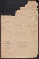
Ground plan of Camp Supply. and Ground plan of Fort Sill.
Description:
Includes "Ground plan of Fort Sill" and "Ground plan of Camp Supply."
Publisher:
Dept. of the Missouri?], and R.P. Studley)
Subject (Geographic):
Indian Territory--Maps
Subject (Name):
R.P. Studley Co, Ruffner, E. H. (Ernest Howard), b. 1845, and United States. Army. Dept. of the Missouri
Found in:
Beinecke Rare Book and Manuscript Library > Military map of the Indian Territory / compiled under the direction of 1st Lieut. E.H. Ruffner, Engineers, Chief Engineer, Department of the Missouri ; drawn and engraved by Ado Hunnius.