Skip to search
Skip to main content
Skip to first result
Search
You Searched For
Subject (Geographic)
Indonesia--Maps
New Search
Search Results
Published / Created:
1811
Call Number:
27 1811
Container / Volume:
BRBL_00023A
Image Count:
1
Resource Type:
Maps, Atlases & Globes
Description:
Preliminary record.
Publisher:
J. Cary,
Subject (Geographic):
Indonesia--Maps
Found in:
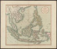
Beinecke Rare Book and Manuscript Library > A New Map of the East India Isles ... John Cary, Engraver.
Published / Created:
1801
Call Number:
27 1801
Container / Volume:
BRBL_00023A
Image Count:
1
Resource Type:
Maps, Atlases & Globes
Description:
Preliminary record.
Subject (Geographic):
Indonesia--Maps
Found in:
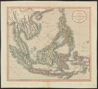
Beinecke Rare Book and Manuscript Library > A New Map of the East India Isles. From the Latest Authorities. By John Cary, Engraver.
Published / Created:
1945
Call Number:
50 1945A
Container / Volume:
BRBL_00273
Image Count:
2
Resource Type:
Maps, Atlases & Globes
Alternative Title:
AAF cloth chart.
Description:
"5/45 SS", Cloth maps., Includes sheet index., and Relief shown by gradient tints and spot heights.
Publisher:
Army Map Service,
Subject (Geographic):
Indonesia--Maps
Subject (Name):
United States. Aeronautical Chart Service and United States. Army Map Service
Subject (Topic):
Military maps
Found in:
Beinecke Rare Book and Manuscript Library > AAF cloth chart. C-800, We Island / Prepared at the direction of the Commanding General, Army Air Forces, by the Aeronautical Chart Service, Washington, D.C., from existing Aeronautical Charts, March 1945, Base No. 1.
Creator:
Published / Created:
1945
Call Number:
50 1945
Container / Volume:
BRBL_00273
Image Count:
2
Resource Type:
Maps, Atlases & Globes
Alternative Title:
AAF cloth chart.
Description:
"3/45 SS" and "4/45 SS", Cloth maps., Includes sheet index, map "Index to boundaries," and "Conversion table.", and Relief shown by gradient tints and spot heights.
Publisher:
Army Map Service,
Subject (Geographic):
Indonesia--Maps
Subject (Name):
United States. Aeronautical Chart Service and United States. Army Map Service
Subject (Topic):
Military maps
Found in:
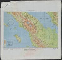
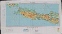
Beinecke Rare Book and Manuscript Library > AAF cloth chart. No. C-48 West Java / reproduced under the direction of the Commanding General, Army Air Forces for the Aeronautical Chart Service by the Army Map Service, Washington D.C. ; copied by Lake Survey Branch, A.M.S., Detroit, Michigan, July 194
Creator:
Published / Created:
1945
Call Number:
27 1945A
Container / Volume:
BRBL_00023B
Image Count:
1
Resource Type:
Maps, Atlases & Globes
Description:
"From: Army Map Service map no. 9306 (G.S.G.S. 4204) 1944.", "No. A-6150.", and Relief shown by contours, form lines and spot heights.
Publisher:
Reproduction Branch, OSS,
Subject (Geographic):
Indonesia--Maps
Found in:
Beinecke Rare Book and Manuscript Library > Arafura, Banda, and Ceram seas / R & A, OSS.
Published / Created:
1845
Call Number:
27 1845
Container / Volume:
BRBL_00023A
Image Count:
1
Resource Type:
Maps, Atlases & Globes
Description:
Platt's grosser Atlas der Erde No. 51. and Preliminary record.
Publisher:
Rubach'schen,
Subject (Geographic):
Indonesia--Maps
Found in:
Beinecke Rare Book and Manuscript Library > Der Asiatische Archipel Lith. ... Albr. Platt.
Published / Created:
1813
Call Number:
27 1813
Container / Volume:
BRBL_00023A
Image Count:
1
Resource Type:
Maps, Atlases & Globes
Description:
From Pinkerton's Modern Atlas and Preliminary record.
Publisher:
Cadell & Davies,
Subject (Geographic):
Indonesia--Maps
Found in:
Beinecke Rare Book and Manuscript Library > East India Isles. Neele Sculpt. Strand.
Published / Created:
1835
Call Number:
27cea 1835
Container / Volume:
BRBL_00023D
Image Count:
1
Resource Type:
Maps, Atlases & Globes
Description:
Bangka, Bilhiton, Java, Bali, Lombock, Sumbawa, Flores, Sandelbusch, Borneo, Celebes, ect. and Preliminary record.
Publisher:
J. Perthes,
Subject (Geographic):
Indonesia--Maps
Found in:
Beinecke Rare Book and Manuscript Library > Reduzirte Karte vom Sunda oder Borneo-Meere ... Berghaus. Gest. V.W. Jattnig in Berlin.
Creator:
Published / Created:
1944?]
Call Number:
27 1944B
Container / Volume:
BRBL_00023B
Image Count:
2
Resource Type:
Maps, Atlases & Globes
Alternative Title:
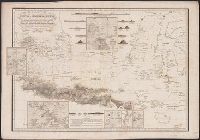
Borneo (south west), Sumatra (extreme south), Java (east & west), Sheet H, Borneo (south west), Sumatra (extreme south), Java (east & west), and Sumatra (south), Java (extreme north west)
Description:
Cloth map., Includes notes, index map, and key to abbreviations., Publisher's designations in upper margins: 44/G -- 44/H., Relief shown by contours, gradient tints, and spot heights. Depths shown by soundings., and Sheet H in 3 sections.
Publisher:
MI9,
Subject (Geographic):
Indonesia--Maps
Found in:
Beinecke Rare Book and Manuscript Library > Sheet G, Sumatra (south), Java (extreme north west) ; Sheet H, Borneo (south west), Sumatra (extreme south), Java (east & west).
Creator:
Published / Created:
1910
Call Number:
27 1910
Container / Volume:
BRBL_00023A
Image Count:
1
Resource Type:
Maps, Atlases & Globes
Description:
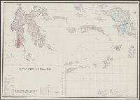
Inset: Stand van de Landrente-Metingen op Java en Madoera. Scale 1:3,500,000.
Publisher:
Topogr[afische] Inr[ichting],
Subject (Geographic):
Indonesia--Maps
Found in:
Beinecke Rare Book and Manuscript Library > Stand van het kaarteeringswerk in den Nederlandsch O.I. Archipel.
Branch:v1.64.0 ,Deployed:2024-09-11T10:25:25-04:00