Search
You Searched For
Search Results
- Creator:
- Bartholomew, John, 1831-1893, cartographer
- Published / Created:
- [between 1852 and 1860]
- Call Number:
- BrSides 2019 71
- Collection Title:
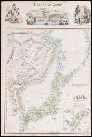
- Royal illustrated atlas of modern geography.
- Image Count:
- 1
- Resource Type:
- Maps, Atlases & Globes
- Alternative Title:
- Islands of Japan, Japanese nobleman & fishermen., Japanese women of the higher & lower class., and Port of Simonoseke, Japan.
- Description:
- Imperfect: trimmed at right, with some loss of text.
- Publisher:
- A. Fullarton & Co.,
- Subject (Geographic):
- Amur River (China and Russia)--Maps., Japan--Maps, Korea--Maps, Manchuria (China)--Maps., and Nagasaki-shi Region (Japan)--Maps.
- Subject (Name):
- A. Fullarton & Co., publisher, Bartholomew, John, 1805-1861, engraver, and Dunlop, John, artist.
- Found in:
- Beinecke Rare Book and Manuscript Library > Japan, Mandshuria (showing the course of the Amur River), the Kurile Isles &c. : according to the British & Russian admiralty surveys, Krusenstern, Siebold &c. / by J. Bartholomew, Junr. ; engraved by J. Bartholomew.
