Skip to search
Skip to main content
Skip to first result
Search
You Searched For
Subject (Geographic)
Kansas--Maps
Search Results
Creator:
Published / Created:
[1855?]
Call Number:
824 1855A
Container / Volume:
BRBL_00570
Image Count:
1
Resource Type:
Maps, Atlases & Globes
Alternative Title:
Territory acquired from Mexico by the Gadsden Treaty.
Description:
"Entered according to act of Congress in the year 1855[?] by J.H. Colton in the clerks office of the district court of the United States for the southern district of New York."
Publisher:
J.H. Colton & Co.,
Subject (Geographic):
Kansas--Maps, Nebraska--Maps, and West (U.S.)--Maps
Subject (Name):
Mexico.--Treaties, etc.--United States,--1853 Dec. 30--Maps
Found in:
Beinecke Rare Book and Manuscript Library > Nebraska and Kansas.
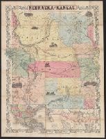
Creator:
Published / Created:
1857
Call Number:
824 1857D
Container / Volume:
BRBL_00570
Image Count:
1
Resource Type:
Maps, Atlases & Globes
Alternative Title:
Territory acquired from Mexico by the Gadsden Treaty.
Description:
Covers Nebraska extending to the Canadian border and westward to Oregon and Kansas including present day Colorado.
Publisher:
J.H. Colton & Co.,
Subject (Geographic):
Kansas--Maps, Nebraska--Maps, and West (U.S.)--Maps
Subject (Name):
Mexico.--Treaties, etc.--United States,--1853 Dec. 30--Maps
Found in:
Beinecke Rare Book and Manuscript Library > Nebraska and Kansas.
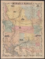
Creator:
Published / Created:
[1854?]
Call Number:
824 1854A
Container / Volume:
BRBL_00570
Image Count:
1
Resource Type:
Maps, Atlases & Globes
Alternative Title:
Map of the territory acquired from Mexico by the Gadsden Treaty, 1854.
Description:
Covers Nebraska extending to the Canadian border and westward to Oregon and Kansas including present day Colorado.
Publisher:
J.H. Colton & Co.,
Subject (Geographic):
Kansas--Maps, Nebraska--Maps, and West (U.S.)--Maps
Subject (Name):
Mexico.--Treaties, etc.--United States,--1853 Dec. 30--Maps
Found in:
Beinecke Rare Book and Manuscript Library > Nebraska and Kansas.
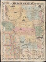
Creator:
Published / Created:
19--?]
Call Number:
824 1854B
Container / Volume:
BRBL_00570
Image Count:
1
Resource Type:
Maps, Atlases & Globes
Alternative Title:
Map of the territory acquired from Mexico by the Gadsden Treaty, 1854.
Description:
Covers Nebraska extending to the Canadian border and westward to Oregon and Kansas including present day Colorado.
Publisher:
s.n.,
Subject (Geographic):
Kansas--Maps, Nebraska--Maps, and West (U.S.)--Maps
Subject (Name):
Mexico.--Treaties, etc.--United States,--1853 Dec. 30--Maps
Found in:
Beinecke Rare Book and Manuscript Library > Nebraska and Kansas.
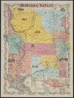
Creator:
Published / Created:
1857
Call Number:
824 1857D
Container / Volume:
BRBL_00570
Image Count:
1
Resource Type:
Maps, Atlases & Globes
Alternative Title:
Territory acquired from Mexico by the Gadsden Treaty.
Description:
Covers Nebraska extending to the Canadian border and westward to Oregon and Kansas including present day Colorado.
Publisher:
J.H. Colton & Co.,
Subject (Geographic):
Kansas--Maps, Nebraska--Maps, and West (U.S.)--Maps
Subject (Name):
Mexico.--Treaties, etc.--United States,--1853 Dec. 30--Maps
Found in:
Beinecke Rare Book and Manuscript Library > Nebraska and Kansas.
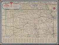
Creator:
Published / Created:
[1936?]
Call Number:
825gmb 1936
Container / Volume:
BRBL_00576
Image Count:
2
Resource Type:
Maps, Atlases & Globes
Alternative Title:
Conoco official road map, Kansas, Kansas, and Travel Kansas with Conoco
Description:
"333-J" and "11-J."
Publisher:
H.M. Goushá Company,
Subject (Geographic):
Kansas--Maps
Subject (Name):
Conoco Travel Bureau
Subject (Topic):
Roads--Kansas--Maps
Found in:
Beinecke Rare Book and Manuscript Library > Official road map of Kansas / [Prepared for] Conoco Travel Bureau.
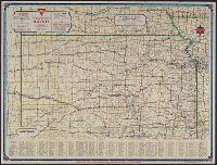
Creator:
Published / Created:
1938
Call Number:
825gmb 1938
Container / Volume:
BRBL_00576
Image Count:
2
Resource Type:
Maps, Atlases & Globes
Alternative Title:
Conoco official road map of Kansas, Kansas, and Travel Kansas with Conoco
Description:
"333-J.C. 10-L" and "1381."
Publisher:
H.M. Goushá Company,
Subject (Geographic):
Kansas--Maps
Subject (Name):
Conoco Travel Bureau
Subject (Topic):
Roads--Kansas--Maps
Found in:
Beinecke Rare Book and Manuscript Library > Official road map of Kansas / [prepared for] Conoco Travel Bureau.
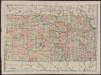
Creator:
Published / Created:
[between 1877 and 1883?]
Call Number:
825fac 1883
Container / Volume:
BRBL_00575
Image Count:
1
Resource Type:
Maps, Atlases & Globes
Alternative Title:
Topographical map of Kansas from the official atlas of Kansas
Description:
Relief shown by shading.
Subject (Geographic):
Kansas--Maps
Subject (Topic):
Railroads--Kansas--Maps
Found in:
Beinecke Rare Book and Manuscript Library > Official topographical map of Kansas / compiled from government surveys, official records, and personal investigations.
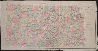
Creator:
Published / Created:
1891
Call Number:
825 1891
Container / Volume:
BRBL_00573
Image Count:
1
Resource Type:
Maps, Atlases & Globes
Alternative Title:
Kansas and Rand McNally & Co.'s new business atlas map of Kansas.
Description:
Title below scale: Rand McNally & Co.'s new business atlas map of Kansas.
Publisher:
Rand McNally,
Subject (Geographic):
Kansas--Maps
Found in:
Beinecke Rare Book and Manuscript Library > Rand McNally & Co.'s Kansas.
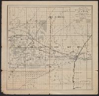
Published / Created:
1874?]
Call Number:
825 1874
Container / Volume:
BRBL_00573
Image Count:
1
Resource Type:
Maps, Atlases & Globes
Description:
"For sale by the Atchison Topeka & Santa Fe Rail Road Company on 5 years credit and 7 percent interest."
Publisher:
s.n.,
Subject (Geographic):
Kansas--Maps
Subject (Name):
Atchison, Topeka, and Santa Fe Railroad Company and Cutler, A. F.--Stamp
Subject (Topic):
Railroad land grants--Kansas--Maps
Found in:
Beinecke Rare Book and Manuscript Library > Sectional map of the Pottawattomie Reserve lands : remaining unsold July 1st 1874.