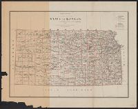
At head of title: No. 1., From: Report of the Commissioner of the General Land Office. 1856. (34th Cong., 1st Sess., Sen. Ex. Doc. no. 1), and Shows drainage, Indian reservations, etc.
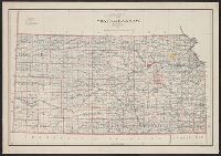
"Entered in Sta. Hall, London - & according to act of Congress in the year 1857 by H.D. Rogers, in the Clerks Office of the District Court of Massachusetts.", I, In top margin: Atlas of United States &c., 12., and Shows proposed Pacific Railway routes in purple.
Publisher:
John Murray ; and W. & A.K. Johnston,
Subject (Geographic):
Colorado--Maps, Indian Territory--Maps, and Kansas--Maps
Subject (Name):
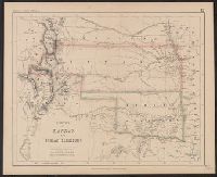
John Murray (Firm), Johnston, Alexander Keith, 1804-1871, and Rogers, Henry D. (Henry Darwin), 1808-1866. Atlas of the United States of North America, Canada, New Brunswick, Nova Scotia, Newfoundland, Mexico, Central America, Cuba and Ja
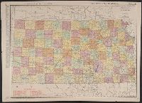
New commercial atlas map of Kansas and Rand, McNally & Co.'s new business atlas map of Kansas.
Description:
"260" and "261.", Also shows railroads., In lower right corner: Rand, McNally & Co.'s new business atlas map of Kansas. Copyright 1903 by Rand McNally & Co., In top margin: Commercial atlas of America, Kansas., Inde, Indexed on verso., and Relief shown by hachures.
Publisher:
Rand McNally,
Subject (Geographic):
Kansas--Maps
Subject (Name):
Rand McNally and Company. Commercial atlas of America
Also shows railroads., Date inferred from estimated 1914 population on verso., In lower right: 217A., Indexed on verso., Indexed., and Relief shown by hachures.