Skip to search
Skip to main content
Skip to first result
Search
You Searched For
Subject (Geographic)
London (England)--Aerial views--Early works to 1800--Facsimiles
Search Results
Creator:
Published / Created:
1662?] and 1912.
Call Number:
32 L84 1662/1912
Container / Volume:
BRBL_00737
Image Count:
1
Resource Type:
Maps, Atlases & Globes
Description:
"Emery Walker, ph. sc."
Publisher:
London Topographical Society,
Subject (Geographic):
Greenwich (London, England)--Aerial views--Early works to 1800--Facsimiles, London (England)--Aerial views--Early works to 1800--Facsimiles, and London (England)--Maps--Early works to 1800--Facsimiles
Subject (Name):
London Topographical Society
Found in:
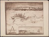
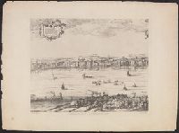
Beinecke Rare Book and Manuscript Library > A prospect and map of London, showing the River Thames to Woolwich reach. Drawn by Jonas Moore in 1662.
Creator:
Published / Created:
1658. and 1905.
Call Number:
32 L84 1658/1905
Container / Volume:
BRBL_00737
Image Count:
12
Resource Type:
Maps, Atlases & Globes
Description:
Includes text, 2 indexed lists of churches, 12 coats of "The armes of the right worll. companies of the honorable cyty of London," illus. of "S. Peters, Westminster" and "S. Pauls, London," and diagr. of "Genealogia Bruti fundatoris vrbis Londini."
Publisher:
London Topographical Society,
Subject (Geographic):
London (England)--Aerial views--Early works to 1800--Facsimiles, Southwark (London, England)--Aerial views--Early works to 1800--Facsimiles, and Westminster (London, England)--Aerial views--Early works to 1800--Facsimiles
Subject (Name):
Faithorne, William, 1616-1691 and London Topographical Society
Found in:
Beinecke Rare Book and Manuscript Library > An exact delineation of the cities of London and Westminster and the suburbs thereof, together wth. ye burrough of Sovthwark and all ye through-fares, highwaies, streetes, lanes & common allies wthin. ye same. Composed by a scale, and ichnographically described by Richard Newcovrt of Somerton in the countie of Somersett, gentleman. Willm. Faithorne, sculpsit.
Creator:
Published / Created:
[1669?] and 1908-1909.
Call Number:
32 L84 1667/1908
Container / Volume:
BRBL_00737
Image Count:
2
Resource Type:
Maps, Atlases & Globes
Alternative Title:
Exact surveigh of the streets, lanes, and chvrches contained within the rvines of the city of London.
Description:
"Ionas Moore & Ralph Graterix, surveyors."
Publisher:
London Topographical Society, and Nathanaell Brooke, stationer
Subject (Geographic):
London (England)--Aerial views--Early works to 1800--Facsimiles
Subject (Name):
Hollar, Wenceslaus, 1607-1677 and London Topographical Society
Found in:
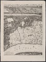
Beinecke Rare Book and Manuscript Library > An exact svrveigh of the streets, lanes, and chvrches contained within the rvines of the city of London; first described in six plats by Iohn Leake, Iohn Iennings, William Marr, Willm. Leybovrn, Thomas Streete, & Richard Shortgrave in Decber. ao. 1666; by the order of the Lord Mayor, aldermen, and common covncell of the said city; reduced here into one intire plat by Iohn Leake ... Wenceslaus Hollar, fecit, 1667.
Creator:
Published / Created:
1905
Call Number:
32 L84 1570/1905
Container / Volume:
BRBL_00737
Image Count:
8
Resource Type:
Maps, Atlases & Globes
Alternative Title:
Plan of London (circa 1560-1570) by Ralph Agas
Description:
Bird's-eye-view.
Publisher:
London Topographical Society,
Subject (Geographic):
London (England)--Aerial views--Early works to 1800--Facsimiles
Subject (Name):
London Topographical Society
Found in:
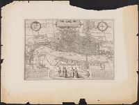
Beinecke Rare Book and Manuscript Library > Civitas Londinum.
Creator:
Published / Created:
1572. and 1882-1883.
Call Number:
32 L84 1572/1882
Container / Volume:
BRBL_00736
Image Count:
1
Resource Type:
Maps, Atlases & Globes
Description:
"The Topographic Etching Co., ph. sc."
Publisher:
Topographical Society of London,
Subject (Geographic):
London (England)--Aerial views--Early works to 1800--Facsimiles
Subject (Name):
Hogenberg, Frans, approximately 1539-1590, joint author and London Topographical Society
Found in:
Beinecke Rare Book and Manuscript Library > Londinvm feracissimi Angliae Regni metropolis.
Creator:
Published / Created:
1682] and 1904.
Call Number:
32 L84 1682/1904
Container / Volume:
BRBL_00737
Image Count:
12
Resource Type:
Maps, Atlases & Globes
Alternative Title:
A prospect of London and Westminster.
Description:
"This survey was begun by Mr. Ogilby, and finished & humbly dedicated by Wm. Morgan."
Publisher:
London Topographical Society,
Subject (Geographic):
London (England)--Aerial views--Early works to 1800--Facsimiles, London (England)--Maps--Early works to 1800--Facsimiles, and Westminster (London, England)--Aerial views--Early works to 1800--Facsimiles
Subject (Name):
Lea, Philip, active 1683-1700, London Topographical Society, Morden, Robert, approximately 1650-1703, and Ogilby, John, 1600-1676
Found in:
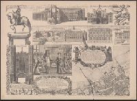
Beinecke Rare Book and Manuscript Library > London &c. actually surveyed, by Wm. Morgan, his ma[jes]ties cosmogr., 1681/2.
Creator:
Published / Created:
1616. and 1883-1885.
Call Number:
32 L84 1616/1883
Container / Volume:
BRBL_00736
Image Count:
4
Resource Type:
Maps, Atlases & Globes
Alternative Title:
View of London.
Description:
"A facsimile of the probably unique example of the original edition in the
Publisher:
Topographical Society of London,
Subject (Geographic):
London (England)--Aerial views--Early works to 1800--Facsimiles and London (England)--Pictorial works--Early works to 1800--Facsimiles
Subject (Name):
London Topographical Society
Found in:
Beinecke Rare Book and Manuscript Library > London. Visscher delineavit.
Creator:
Published / Created:
1647. and 1906-1907.
Call Number:
32 L84 1647/1906
Container / Volume:
BRBL_00737
Image Count:
6
Resource Type:
Maps, Atlases & Globes
Description:
"Emery Walker, ph. sc."
Publisher:
Cornelius Danckers, and London Topographical Society,
Subject (Geographic):
London (England)--Aerial views--Early works to 1800--Facsimiles and London (England)--Pictorial works--Early works to 1800--Facsimiles
Subject (Name):
Danckerts, Cornelis, 1561-1634 and London Topographical Society
Found in:
Beinecke Rare Book and Manuscript Library > London. Wenceslaus Hollar delineavit et fecit Londini et Antverpiæ, 1647.
Creator:
Published / Created:
1593. and 1899.
Call Number:
32 L84 1593/1899
Container / Volume:
BRBL_00736
Image Count:
2
Resource Type:
Maps, Atlases & Globes
Description:
"From the 'Speculum Britanniæ' of John Norden, London 1593, 4to."
Publisher:
London Topographical Society,
Subject (Geographic):
London (England)--Aerial views--Early works to 1800--Facsimiles and Westminster (London, England)--Aerial views--Early works to 1800--Facsimiles
Subject (Name):
Keere, Pieter van den, 1571-ca. 1646 and London Topographical Society
Found in:
Beinecke Rare Book and Manuscript Library > Norden's maps of London and Westminster. Engraved by Pieter van den Keere, 1593.