Skip to search
Skip to main content
Skip to first result
Search
You Searched For
Subject (Geographic)
Louisiana--Maps--Early works to 1800
Search Results
Creator:
Published / Created:
1752?]
Call Number:
71 1752B
Container / Volume:
BRBL_00725
Image Count:
1
Resource Type:
Maps, Atlases & Globes
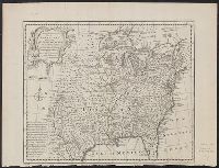
Alternative Title:
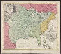
A new and accurate map of Louisiana, with part of Florida and Canada, and the adjacent countries
Description:
"No. 100."
Subject (Geographic):
Louisiana--Maps--Early works to 1800 and North America--Maps--Early works to 1800
Found in:
Beinecke Rare Book and Manuscript Library > A new & accurate map of Louisiana, with part of Florida and Canada, and the adjacent countries / drawn from surveys, assisted by the most approved English & French maps & charts, the whole being regulated by astronl. observations. By Eman. Bowen.
Creator:
Published / Created:
1752?]
Call Number:
71 1752
Container / Volume:
BRBL_00362
Image Count:
1
Resource Type:
Maps, Atlases & Globes
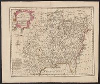
Alternative Title:
A new and accurate map of Louisiana, with part of Florida and Canada, and the adjacent countries
Description:
"No. 100."
Subject (Geographic):
Louisiana--Maps--Early works to 1800 and North America--Maps--Early works to 1800
Found in:
Beinecke Rare Book and Manuscript Library > A new & accurate map of Louisiana, with part of Florida and Canada, and the adjacent countries / drawn from surveys, assisted by the most approved English & French maps & charts, the whole being regulated by astronl. observations. By Eman. Bowen.
Creator:
Published / Created:
between 1730 and 1763?]
Call Number:
71 1730
Container / Volume:
BRBL_00362
Image Count:
1
Resource Type:
Maps, Atlases & Globes
Description:
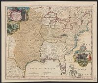
Appears in Homann Erben's Atlas geographicus major [1759 or 1763?].
Publisher:
[Homannianis heredibus?,
Subject (Geographic):
Louisiana--Maps--Early works to 1800 and North America--Maps--Early works to 1800
Subject (Name):
Hennepin, Louis, 17th cent and Homann Erben (Firm). Atlas geographicvs maior
Found in:
Beinecke Rare Book and Manuscript Library > Amplissimae regionis Mississipi seu Provinciae Ludovicianae : â R.P. Ludovico Hennepin Francisc. Miss. in America Septentrionali anno 1687 detectae. nunc Gallorum Coloniis et actionum negotiis toto orbe celeberrimae, nova tabula / edita à Io. Bapt. Homa
Creator:
Published / Created:
between 1719 and 1781?]
Call Number:
71 17XXA
Container / Volume:
BRBL_00367
Image Count:
1
Resource Type:
Maps, Atlases & Globes
Description:
Includes ill. and text.
Publisher:
[s.n.,
Subject (Geographic):
Louisiana--Maps--Early works to 1800, Mississippi River Valley--Maps--Early works to 1800, and North America--Maps--Early works to 1800
Found in:
Beinecke Rare Book and Manuscript Library > Amplissimae regionis Mississipi seu Provinciae Ludovicianae â R.P. Ludovico Hennepin Francisc. Miss. in America Septentrionali anno 1687 / detectae nunc Gallorum Coloniis et actionum negotiis toto orbe celeberrimae, nova tabula edita à Io. Bapt. Homanno
Creator:
Published / Created:
Novembre MDCCLV [1755]
Call Number:
71 1755T
Container / Volume:
BRBL_00364
Image Count:
3
Resource Type:
Maps, Atlases & Globes
Description:
"Sous le privilége de l'Academie."
Publisher:
Chez l'auteur, aux galeries du Louvre, ‡c Novembre MDCCLV [1755]
Subject (Geographic):
Canada--Maps--Early works to 1800, Louisiana--Maps--Early works to 1800, and North America--Maps--Early works to 1800
Subject (Name):
Anville, Jean Baptiste Bourguignon d', 1697-1782. Atlas général and Haye, G. de la, engraver
Found in:
Beinecke Rare Book and Manuscript Library > Canada, Louisiane et terres angloises / par le Sr. d'Anville ... ; [gravée par] G. De-La-Haye.
Call Number:
Zc20 931pi
Collection Title:
Pichardo’s treatise on the limits of Louisiana and Texas : an argumentative historical treatise
Image Count:
1
Alternative Title:
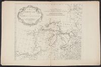
Section of the Langara map of the coasts of the Mexican Gulf, 1799-1805.
Description:
Bound in between p. 350-51.
Subject (Geographic):
Florida--Maps--Early works to 1800, Louisiana--Maps--Early works to 1800, Mexico, Gulf of--Maps--Early works to 1800, and Mexico--Maps--Early works to 1800
Collection Created:
Austin, Tex. : The University of Texas Press, 1931-1946
Found in:
Beinecke Rare Book and Manuscript Library > Carta esferica que comprehende las costas del Seno Mexicano construida de orden del Rey ... Don Juan de Langara
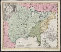
Creator:
Published / Created:
1744]
Call Number:
755 1744
Container / Volume:
BRBL_00426
Image Count:
1
Resource Type:
Maps, Atlases & Globes
Description:
Appears in Charlevoix's histoire et description generale de la Nouvelle France.
Publisher:
N. Bellin,
Subject (Geographic):
Louisiana--Maps--Early works to 1800 and United States--Maps--Early works to 1800
Subject (Name):
Charlevoix, Pierre, Charlevoix, Pierre-François-Xavier de, 1682-1761, and Heulland, Guillaume d', d. ca. 1770
Found in:
Beinecke Rare Book and Manuscript Library > Carte de la Louisiane cours du Mississipi [i.e. Mississippi] et pais voisins : dediée à M. le Comte de Maurepas, ministre et secretaire d'etat commandeur des ordres du roy / par N. Bellin ingenieur de la marine, 1744 ; Dheulland sculp.
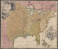
Creator:
Published / Created:
[1730?]
Call Number:
755 1730
Container / Volume:
BRBL_00426
Image Count:
1
Resource Type:
Maps, Atlases & Globes
Description:
Bar scale given in "echelle de cent lieues Francoises".
Publisher:
Chez Jean Cóvens et Corneille Mortier, geographes,
Subject (Geographic):
Louisiana--Maps--Early works to 1800, Mississippi River Valley--Maps--Early works to 1800, and United States--Maps--Early works to 1800
Subject (Name):
Cóvens et Mortier. Atlas nouveau and Le Maire, François
Found in:
Beinecke Rare Book and Manuscript Library > Carte de la Louisiane et du cours du Mississipi / dressée sur un grand nombre de memoires entr'autres sur ceux de Mr. le Maire, par Guillme. de L'Isle de l'Academie Rle. des Sciences.