Skip to search
Skip to main content
Skip to first result
Search
You Searched For
Subject (Geographic)
Maine--Maps
New Search
Search Results
Published / Created:
[after 1842]
Call Number:
BrSides Elephant Folio 2018 19
Image Count:
1
Resource Type:
Maps, Atlases & Globes
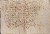
Description:
Coordinates not present on map and are approximated., Imperfect: mutilated., Relief shown by hachures., Shows government surveys with landowner and property boundaries drawn in., and Title devised by cataloger.
Subject (Geographic):
Maine--Maps
Subject (Topic):
Real property--Maine--Maps.
Found in:
Beinecke Rare Book and Manuscript Library > [Manuscript map of the northern third of Maine].
Published / Created:
19--.
Call Number:
761 M79 1883
Container / Volume:
BRBL_00448
Image Count:
1
Resource Type:
Maps, Atlases & Globes
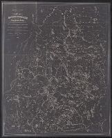
Description:
Negative photocopy or original map.
Publisher:
s.n. ,
Subject (Geographic):
Maine--Maps and Moosehead Lake (Me.)--Maps
Found in:
Beinecke Rare Book and Manuscript Library > [Map of Moosehead Lake and northern Maine, embracing the headwaters of the Penobscot, Kennebec and St. John rivers : specially adapted to the uses of sportsmen and lumbermen / compiled and published by Lucius L. Hubbard].
Published / Created:
19--.
Call Number:
761 R16 1880
Container / Volume:
BRBL_00449
Image Count:
1
Resource Type:
Maps, Atlases & Globes
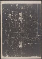
Description:
Negative photocopy of unknown original. and Shows timber ranges.
Publisher:
s.n. ,
Subject (Geographic):
Maine--Maps
Found in:
Beinecke Rare Book and Manuscript Library > [Map of the Rangeley Lake District, Maine] / copied from the surveys of Ballard and Perham & co. from a scale of 2 miles to an inch by Osgood Carleton.
Branch:v1.64.0 ,Deployed:2024-09-11T10:25:25-04:00