Skip to search
Skip to main content
Skip to first result
Search
You Searched For
Subject (Geographic)
Mediterranean Sea
Search Results
Creator:
Published / Created:
June 28th, 1780.
Call Number:
1982 Folio 10
Image Count:
1
Description:
BEIN 1982 Folio 10: Armorial bookplate: Charles Abbot. No. 13 of 42 maps bound together.
Publisher:
Engraved & published by Wm. Faden
Subject (Geographic):
Spain, Portugal, Africa, North, and Mediterranean Sea
Subject (Topic):
Nautical charts and Coasts
Found in:
Beinecke Rare Book and Manuscript Library > A chart of the coasts of Spain and Portugal, with the Balearic Islands, and part of the coast of Barbary
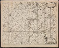
Creator:
Published / Created:
March 1st 1785.
Call Number:
1982 Folio 10
Image Count:
2
Description:
BEIN 1982 Folio 10: Imperfect: torn along some folds, with no loss of text. 58 x 176 cm, sheets 64 x 89 and 65 x 96 cm. Armorial bookplate: Charles Abbot. No. 16 of 42 maps bound together.
Publisher:
Printed for Wm. Faden, Charing Cross
Subject (Geographic):
Mediterranean Sea
Found in:
Beinecke Rare Book and Manuscript Library > A map of the Mediterranean Sea, with the adjacent regions and seas in Europe, Asia, and Africa
Creator:
Published / Created:
[1572?]
Call Number:
1978 +136
Image Count:
116
Description:
BEIN: Imperfect: t.-p. and 35 plates wanting; title supplied by Phillips.
Publisher:
Alla libraria del segno di S. Marco
Subject (Geographic):
Mediterranean Sea
Subject (Topic):
Charts, maps, etc and Cyprian War, 1570-1571
Found in:
Beinecke Rare Book and Manuscript Library > Isole famose porti, fortezze, e terre maritime sottoposte alla Serma. Sigria. di Venetia, ad altri principi christiani, et al Sigor. Turco, nouamẽte poste in luce
Creator:
Published / Created:
[ca. 1720?]
Call Number:
1973 Folio 18
Image Count:
1
Description:
BEIN 1973 Folio 18: Backed with paper. Ms. no. "66" in upper right-hand corner. Sheet measures 53.7 x 62.3 cm. No. 61 of 87 maps bound together.
Publisher:
By Gerard van Keulen, aen de nieuwe Brug met privilegie
Subject (Geographic):
Sardinia (Italy) and Mediterranean Sea
Subject (Topic):
Maps and Nautical charts
Found in:
Beinecke Rare Book and Manuscript Library > Nieuwe en nette afteekening van het eyland of Koninkryk Sardinia vertoonende alle desselfs zee havenen anker plaetsen rivieren dieptens klippen steeden en vastigheeen als mede de Straet van Bonifacio aent eyland Corsica [cartographic material]
Creator:
Published / Created:
[1655]
Call Number:
21 1670B
Image Count:
1
Resource Type:
cartographic image
Description:
BEIN 21 1670B: Manuscript number on verso: 174. Watermark.
Publisher:
Joan Blaeu
Subject (Geographic):
North Atlantic Ocean and Mediterranean Sea
Subject (Topic):
Maps
Found in:
Beinecke Rare Book and Manuscript Library > Paskaerte van de Westersche Schipvaert van Nederland af tot de Canarise en Vlaemse Eylanden
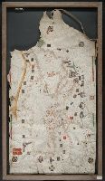
Creator:
Published / Created:
[approximately 1450-1475]
Call Number:
Art Storage 49cea 1425
Image Count:
2
Resource Type:
cartographic image
Description:
BEIN Art Storage 49cea 1425: Imperfect: lower left corner and bottom edge torn, with some loss of map; slight holes throughout. With leather thone tie on left edge.
Publisher:
Petrus Roselli?
Subject (Geographic):
Mediterranean Sea and Black Sea
Subject (Topic):
Maps and Nautical charts
Found in:
Beinecke Rare Book and Manuscript Library > Portolan chart of the Mediterranean Sea and the Black Sea
Published / Created:
[between 1800 and 1899?]
Call Number:
GEN MSS FILE 601 (Oversize)
Image Count:
2
Resource Type:
cartographic image
Description:
Title supplied by cataloger.
Subject (Geographic):
Europe and Mediterranean Sea
Subject (Topic):
Nautical charts
Found in:
Beinecke Rare Book and Manuscript Library > Portolan chart of western Europe and the Mediterranean Sea
Creator:
Call Number:
Osborn fc164
Image Count:
6
Resource Type:
unspecified
Abstract:
Holograph journal of the ship Leviathan, flagship of Admiral Duckworth's command group in the Mediterranean and off Spain from May 1799 to May 1800. The logbook tracks weather conditions, routine activities on all of the ships under his command and si...
Description:
Binding: Contemporary marbled wrappers.
Subject (Geographic):
Great Britain., France, Great Britain, and Mediterranean Sea
Subject (Name):
Nelson, Horatio Nelson, Viscount, 1758-1805., Great Britain. Royal Navy, Bellerophon (Battleship), and Leviathan (Battleship)
Subject (Topic):
Officers, Sea life, Admirals, Napoleonic Wars, 1800-1815, Naval battles, Sea control, Seafaring life, History, and History, Naval
Found in:
Beinecke Rare Book and Manuscript Library > [Logbook of the HMS Leviathan], 1799-1800
Creator:
Published / Created:
an[n]o 1637.
Call Number:
2022 Folio 31
Image Count:
1
Resource Type:
cartographic image
Description:
Portolan chart with seaport names given for all coastlines.
Publisher:
[Placidus Cal]oiro et Oliua fecit in nobili urbe Messanae
Subject (Geographic):
Mediterranean Sea and Black Sea
Subject (Topic):
Maps and Nautical charts
Found in:
Beinecke Rare Book and Manuscript Library > [Portolan chart of the Mediterranean Sea and the Black Sea, with the Atlantic coast from the Netherlands to Morocco, including southern Ireland and southern England].
Published / Created:
[approximately 1960]
Call Number:
Art Storage 1019
Image Count:
2
Resource Type:
cartographic image
Description:
Twentieth century forgery of a portlan chart with seaport names given for all coastlines; based on chart from the circle of Vesconte Maggiolo.
Subject (Geographic):
Mediterranean Sea, North Atlantic Ocean, Black Sea, Africa, West, Mediterranean Sea., North Atlantic Ocean., Black Sea., and Africa, West.
Subject (Topic):
Nautical charts
Found in:
Beinecke Rare Book and Manuscript Library > [Portolan chart of the Mediterranean Sea, the North Atlantic Ocean, the Black Sea, and the northwestern African coast].