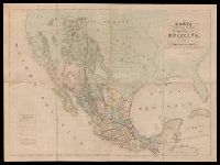
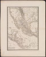
"Engraved by B.R. Davies, 16 George Str. Euston Squ., London. From the original survey made by order of the Mexican Government.", "Esta edicion se hace provicionalmente mientras se concluye la Carta en Escala mayor. Pedro Garcia Conde.", Prime meridian: Mexico City., and Relief shown by hachures.
Publisher:
s.n.,
Subject (Geographic):
Mexico--Maps and West (U.S.)--Maps
Subject (Name):
Davies, Benjamin Rees and García Conde, Pedro, 1806-1851
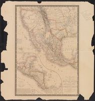
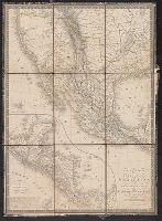
"La gravure dirigée et éxécutée par Lallemand.", From the Streeter collection., In upper left margin: Atlas universel., In upper right margin: 44e., Inset: Carte du Guatemala, ou provinces-unies de l'Améri, Prime meridian: Paris., and Relief shown by hachures.
Publisher:
s.n.,
Subject (Geographic):
Mexico--Maps and Southwest, New--Maps
Subject (Name):
Streeter, Thomas W.--(Thomas Winthrop),--1883-1965--Ownership
Cased with: Map of the Burman Empire. London : G.&J., Hand-colored boundaries., Insets: Guatemala ou Provinces-Unies de l'Amérique Centrale -- Iles Revillagigedo, and Library's copy 2 from the Streeter collection and dissected and mounted on linen, 50 x 35 cm.
Publisher:
A.H. Brué,
Subject (Geographic):
Central America--Maps and Mexico--Maps
Subject (Name):
Streeter, Thomas W.--(Thomas Winthrop),--1883-1965--Ownership
Subject (Topic):
Chron.--1825 and Engraving, Colored--Specimens--1825
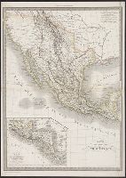
In lower right margin: No. 44., In upper right margin: Atlas universel en 67 feuilles no. 61., Insets: Carte de l'Amérique Centrale -- Iles Revillagigedo., and Relief shown by hachures.
Publisher:
Ch. Delagrave, Editeur de la Société de Géographie, and Institut Géographique de Paris :
Subject (Geographic):
Central America--Maps, Mexico--Maps, and United States--Maps
Subject (Name):
Brué, Adrien Hubert, 1786-1832, Delagrave, Ch. (Charles), 1842-1934, and Institut géographique de Paris
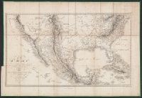
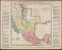
Railroad and military map of the United States, Mexico, the West Indies &c.
Description:
In upper left margin: No. 7. and Insets: Map of the Americas, Africa and a portion of Europe, showing the Atlantic and part of the Pacific oceans -- New Orleans and delta of the Mississippi, Louisiana -- Mobile Harbor, Alabama -- Key West and Tortugas, Florid
Publisher:
J.H. Colton,
Subject (Geographic):
Central America--Maps, Mexico--Maps, United States--Maps, and West Indies--Maps
Subject (Topic):
Military bases--United States--Maps and Railroads--United States--Maps
Complete historical, chronological and geographical American atlas. and Mexico and internal provinces
Description:
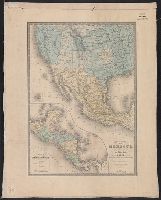
"Mexico, No. 38.", Appears in Complete historical, chronological and geographical American atlas. Philadelphia: H.C. Carey & I. Lea, 1822., Prime meridians: W, and Shows outlines of Mexican intendencias and provinces, towns, rivers, mines, and military outposts.
Publisher:
H.C. Carey & I. Lea,
Subject (Geographic):
Mexico--Maps
Subject (Name):
H.C. Carey & I. Lea (Firm), Streeter, Thomas W.--(Thomas Winthrop),--1883-1965--Ownership, and Young & Delleker