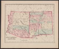
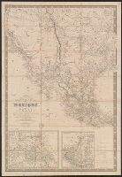
In lower right margin: [Plate] 121., Library's copy received with note indicating map from either Gray's Atlas of the United States or O.W. Gray & Son's National Atlas. Philadelphia, [1877?]., Map of "Mexico" (scale 1:7,920,000) on verso., and Pinal Co. appears in separately colored area, bounded by dashed lines, between Maricopa and Pima counties; differs from earlier 1877 version in no longer showing separately colored, rectangular area in eastern Maricopa and Pima counties.
Publisher:
s.n.?,
Subject (Geographic):
Arizona--Maps, Mexico--Maps, and New Mexico--Maps
Subject (Name):
Gray, Ormando Willis. Gray's atlas of the United States and O.W. Gray & Son. National atlas
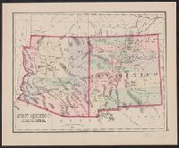
From O.W. Gray & Son's National atlas. Philadelphia, [1881?], In lower right margin: [Plate] 147., Map of "Mexico" (scale 1:7,920,000) on verso., Prime meridians: Greenwich and Washington., Relief shown by hachures., and Shows Southern Pacific R.R. reaching into southwestern New Mexico, and connecting with Denver & Rio Grande R.R.; and a line projected between Maricopa (Ariz.) and Prescott (Ariz.) In New Mexico, railroad runs west of Albuquerque.
"Pinal" appears in area bounded by dashed line within Maricopa and Pima counties; area in eastern Maricopa and Pima counties, labeled "Pinal" in earlier version, remains without label. Also shows Denver & Rio Grande R.R. complete nearly to northern boundary of New Mexico.
Publisher:
s.n.?,
Subject (Geographic):
Arizona--Maps, Mexico--Maps, and New Mexico--Maps
Subject (Name):
Gray, Ormando Willis. Gray's atlas of the United States and O.W. Gray & Son. National atlas
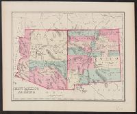
From Gray's Atlas of the United States. Philadelphia, 1875 or 1876., In lower right margin: [Plate] 121., Map of "Mexico" (scale 1:7,920,000) on verso., Prime meridians: Greenwich and Washington., Relief shown by hachures., and Shows Pinal Co. in southeastern Arizona.
Publisher:
s.n.?,
Subject (Geographic):
Arizona--Maps, Mexico--Maps, and New Mexico--Maps
Subject (Name):
Gray, Ormando Willis. Gray's atlas of the United States
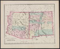
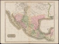
From Gray's atlas of the United States. Philadelphia: N.R. Stedman & Co., 1878., In lower right margin: [Plate] 121., Map of "Mexico" (scale 1:7,920,000) on verso., Prime meridians: Greenwich and Washington., Relief shown by hachures., and Shows five counties in Arizona, and Tucson as capital. Also shows 13 counties in New Mexico, including defunct "Santa Ana" Co.
Publisher:
N.R. Stedman & Co.,
Subject (Geographic):
Arizona--Maps, Mexico--Maps, and New Mexico--Maps
Subject (Name):
Gray, Ormando Willis. Gray's atlas of the United States
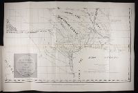
In lower right margin: [Plate] 147., Map of "Mexico" (scale 1:7,920,000) on verso., Possibly from O.W. Gray & Son's National atlas. Philadelphia, [1880?], Prime meridians: Greenwich and Washington., Relief shown by hachures., and Shows Apache County in Arizona and Southern Pacific R.R. complete to Tucson. Also shows San Miguel County in New Mexico encompassing lands labeled Bernalillo and Valencia counties in earlier version; and Denver & Rio Grande R.R. reaching Santa Fe and Albuquerque.
"Entered according to Act of Congress in the year 1850 by John Monk in the Clerks Office of the District of Maryland.", Includes: Legend, Table of distances, routes by water, inland routes, Names of counties and county towns in the United States., and Inset: Ne
Publisher:
Jacob Monk,
Subject (Geographic):
Central America--Maps, Mexico--Maps, North America--Maps, United States--Maps, and West Indies--Maps
"Milles Anglais de 69 1/2 au degré.", "Publiée en 1834 ....", Includes text and insets of "Détails des environs de Mexico et de la Vera-Cruz" and "Complément de la carte donnant le Yucatan et une partie des provinces unies de l-Amérique Centrale.", and Relief shown by hachures.
Publisher:
[Picquet?],
Subject (Geographic):
Mexico--Maps, Southwest, New--Maps, and Texas--Maps
"Drawn & engraved for Thomson's New general atlas.", Appears in A new general atlas ... Edinburgh : John Thomson and Co., From the Streeter collection., In upper right margin: No. 58., and Relief shown by hachures.
Publisher:
John Thomson and Co.,
Subject (Geographic):
Central America--Maps and Mexico--Maps
Subject (Name):
Streeter, Thomas W.--(Thomas Winthrop),--1883-1965--Ownership and Thomson, John, geographer. New general atlas