Skip to search
Skip to main content
Skip to first result
Search
You Searched For
Subject (Geographic)
Michigan--Maps
Search Results
Published / Created:
1836
Call Number:
811 1836
Container / Volume:
BRBL_00552
Image Count:
1
Resource Type:
Maps, Atlases & Globes
Description:
Largest inset: Map of the Straits of Michillimackinac.
Publisher:
J.H. Colton,
Subject (Geographic):
Michigan--Maps
Found in:
Beinecke Rare Book and Manuscript Library > An improved edition of a map of the survryed part of the Territory of Michigan. by John Farmer
Published / Created:
1858
Call Number:
811cea Sa245 1858
Container / Volume:
BRBL_00554
Image Count:
1
Resource Type:
Maps, Atlases & Globes
Alternative Title:
Channel cut of Middle Channel
Description:
"C.B. Graham, lithr."
Publisher:
s.n.] ,
Subject (Geographic):
Michigan--Maps
Subject (Name):
Graham, C. B. (Curtis B.)
Found in:
Beinecke Rare Book and Manuscript Library > Channel cut of Middle Channel, Lake George : St. Mary's River improvement showing character of bottom & extent of dredging up to September 30th 1858 / drawn by James T. Baker, surveyed under the orders of Capt. A.W. Whipple, T.E., by J.H. Forster U.S. Sub
Published / Created:
1858
Call Number:
811cea Sa245 1858A
Container / Volume:
BRBL_00554
Image Count:
1
Resource Type:
Maps, Atlases & Globes
Alternative Title:
Chart of East Neebish rapids
Description:
"Note: The remaining portions of this map are enlarged from a published chart of the U.S. Lake survey made in 1853."
Publisher:
J. Bien, lith.,
Subject (Geographic):
Michigan--Maps
Found in:
Beinecke Rare Book and Manuscript Library > Chart of East Neebish rapids, River St. Mary : showing the improved west channel, dredged and surveyed in 1858 under the direction of Capt. A.W. Whipple, T.E. / J.H. Foster U.S. Sub. Agt., James T. Foster, draughtsman.
Creator:
Published / Created:
1868
Call Number:
805 1868
Container / Volume:
BRBL_00546
Image Count:
1
Resource Type:
Maps, Atlases & Globes
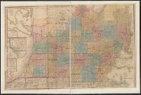
Description:
Includes key to state boundary, county boundary, township & range line, section line, state capitol, county seat, villages & P.O.s, mills, roads, railroads--finished and proposed.
Publisher:
G.W. & C.B. Colton & Co.,
Subject (Geographic):
Illinois--Maps, Indiana--Maps, Michigan--Maps, and Ohio--Maps
Subject (Name):
G.W. & C.B. Colton & Co
Subject (Topic):
Railroads
Found in:
Beinecke Rare Book and Manuscript Library > Colton's map of the state of Indiana : compiled from the United States surveys and other authentic sources. Exhibiting sections, fractional sections, railroads, canals, etc.
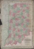
Creator:
Published / Created:
1857
Call Number:
754 1857
Container / Volume:
BRBL_00416
Image Count:
1
Resource Type:
Maps, Atlases & Globes
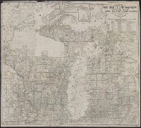
Alternative Title:
Township map of Michigan and Wisconsin.
Description:
1771
Publisher:
John Farmer,
Subject (Geographic):
Michigan--Maps, Superior (Lake, Region)--Maps, and Wisconsin--Maps
Found in:
Beinecke Rare Book and Manuscript Library > Farmer's township map of Michigan and Wisconsin : embracing part of Iowa Illinois and Minnesota, with a chart of the lakes / prepared engraved and published by the author at Detroit.
Creator:
Published / Created:
1866
Call Number:
811ca 1866
Container / Volume:
BRBL_00554
Image Count:
1
Resource Type:
Maps, Atlases & Globes
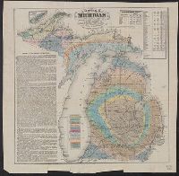
Description:
"Entered according to act of Congress in the year 1865 by Samuel Geil ..."
Publisher:
S. Geil,
Subject (Geographic):
Michigan--Maps
Subject (Name):
Geil, Samuel
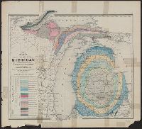
Subject (Topic):
Geology--Michigan--Maps
Found in:
Beinecke Rare Book and Manuscript Library > Geological map of Michigan / by Alexander Winchell.
Published / Created:
1915
Call Number:
812ag 1915
Container / Volume:
BRBL_00556
Image Count:
2
Resource Type:
Maps, Atlases & Globes
Alternative Title:
Hunting and fishing resorts of northwestern Wisconsin
Description:
"287" in bottom right margin.
Publisher:
Rand McNally & Co.,
Subject (Geographic):
Michigan--Maps and Wisconsin--Maps
Found in:
Beinecke Rare Book and Manuscript Library > Hunting and fishing resorts of northern Wisconsin and Michigan : reached by the Chicago and North Western Railway.
Creator:
Published / Created:
[1866]
Call Number:
812 1866
Container / Volume:
BRBL_00555
Image Count:
2
Resource Type:
Maps, Atlases & Globes
Alternative Title:
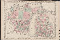
Wisconsin and Michigan
Description:
"Entered according to Act of Congress in the Year 1864, by A.J. Johnson in the Clerks Office of the District Court of the United States for the Southern District of New York."
Publisher:
A.J. Johnson,
Subject (Geographic):
Michigan--Maps and Wisconsin--Maps
Subject (Topic):
Counties--Michigan--Maps, Counties--Wisconsin--Maps, Railroads--Michigan--Maps, and Railroads--Wisconsin--Maps
Found in:
Beinecke Rare Book and Manuscript Library > Johnson's Wisconsin and Michigan.
Creator:
Published / Created:
[1839?]
Call Number:
811 1839A
Container / Volume:
BRBL_00552
Image Count:
4
Resource Type:
Maps, Atlases & Globes
Alternative Title:
Map of Michigan and part of Wisconsin Territory and Michigan & part of Wisconsin Territory
Description:
"Entered according to Act of Congress July 10, 1839 by David H. Burr in the clerk's office of the District Court of the District of Columbia."
Publisher:
J. Arrowsmith,
Subject (Geographic):
Michigan--Maps and Wisconsin--Maps
Subject (Name):
Arrowsmith, John, 1790-1873
Found in:
Beinecke Rare Book and Manuscript Library > Map of Michigan & part of Wisconsin Territory : exhibiting the post offices, post roads, canals, rail roads, &c. / by David H. Burr.
Creator:
Published / Created:
1873]
Call Number:
811ca 1873
Container / Volume:
BRBL_00554
Image Count:
1
Resource Type:
Maps, Atlases & Globes
Description:
Depths shown by contours.
Publisher:
R.M. & S.T. Tackabury,
Subject (Geographic):
Michigan--Maps
Subject (Name):
Walling, Henry Francis, 1825-1888. Atlas of the state of Michigan
Subject (Topic):
Geology--Michigan--Maps
Found in:
Beinecke Rare Book and Manuscript Library > Map of the state of Michigan colored to show the geological formations / by Alexander Winchell.