Skip to search
Skip to main content
Skip to first result
Search
You Searched For
Subject (Geographic)
Missouri--Maps
Search Results
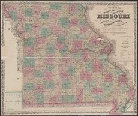
Creator:
Published / Created:
1862
Call Number:
754gme 1860A
Container / Volume:
BRBL_00420
Image Count:
1
Resource Type:
Maps, Atlases & Globes
Alternative Title:
Colton's county and township railroad map of Wisconsin, Illinois, Missouri, & Iowa, County and township rail road map of Wisconsin, Illinois, Missouri, & Iowa, and Wisconsin, Illinois, Missouri, & Iowa
Description:
"Entered according to Act of Congress by Thayer & Colton in the Clerk's office of the District Court of the United States for the Southern District of New York in t
Publisher:
Drawn, engraved & published by G. Woolworth Colton; and Rufus Blanchard,
Subject (Geographic):
Illinois--Maps, Iowa--Maps, Missouri--Maps, and Wisconsin--Maps
Subject (Name):
Blanchard, Rufus, 1821-1904
Subject (Topic):
Railroads--Illinois--Maps, Railroads--Iowa--Maps, Railroads--Missouri--Maps, and Railroads--Wisconsin--Maps
Found in:
Beinecke Rare Book and Manuscript Library > Colton's county and township rail road map of Wisconsin, Illinois, Missouri, & Iowa / Drawn, engraved & published by G. Woolworth Colton
Creator:
Published / Created:
1867
Call Number:
816 1867
Container / Volume:
BRBL_00561
Image Count:
1
Resource Type:
Maps, Atlases & Globes
Alternative Title:
Sectional map of the state of Missouri
Description:
"Entered according to act of Congress in the year 1860 by J.H. Colton in the clerks office of the district court for the southern district of New York."
Publisher:
G.W. & C.B. Colton & Co.,
Subject (Geographic):
Missouri--Maps
Subject (Name):
Colton, J. H. (Joseph Hutchins), 1800-1893
Found in:
Beinecke Rare Book and Manuscript Library > Colton's sectional map of the state of Missouri : compiled from the United States surveys & other authentic sources, exhibiting the sections, fractional sections, counties, cities, towns, villages, post offices, rail roads & other internal improvements.
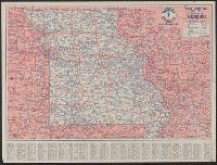
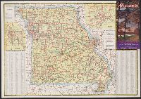
Creator:
Published / Created:
[1929]
Call Number:
816gmb 1929
Container / Volume:
BRBL_00564
Image Count:
2
Resource Type:
Maps, Atlases & Globes
Alternative Title:
1929 road map of Missouri, Conoco 1929 road map of Missouri, Missouri, and Official road map, Missouri
Description:
In lower right: C-134 J.C.
Publisher:
H.M. Gousha,
Subject (Geographic):
Missouri--Maps
Subject (Name):
Continental Oil Company
Subject (Topic):
Roads--Missouri--Maps
Found in:
Beinecke Rare Book and Manuscript Library > Continental Oil Co. official road map, Missouri / compliments of Continental Oil Co.
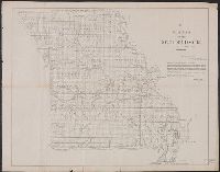
Creator:
Published / Created:
1850?]
Call Number:
816 1850
Container / Volume:
BRBL_00561
Image Count:
1
Resource Type:
Maps, Atlases & Globes
Alternative Title:
Senate executive document (United States. Congress. Senate) ; 31st Congress, 2nd session, no. 2.
Description:
"M. Lewis Clark, Surveyor General."
Publisher:
s.n.,
Subject (Geographic):
Missouri--Maps
Subject (Name):
Clark, M. Lewis
Found in:
Beinecke Rare Book and Manuscript Library > Diagram of the state of Missouri : accompanying report of 20th Novr. 1850 / Office of the Surveyor General for Illinois and Missouri, St. Louis, 20th Novr. 1850.
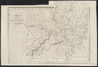
Published / Created:
1847 or 1848?]
Call Number:
816fcm 1847
Container / Volume:
BRBL_00563
Image Count:
1
Resource Type:
Maps, Atlases & Globes
Description:
"F.R. Conway, Surveyor of the public lands in the states of Illinois and Missouri."
Publisher:
s.n.,
Subject (Geographic):
Missouri--Maps
Subject (Name):
Conway, F. R
Found in:
Beinecke Rare Book and Manuscript Library > Diagram of the state of Missouri.
Creator:
Published / Created:
1866]
Call Number:
816 1866
Container / Volume:
BRBL_00561
Image Count:
2
Resource Type:
Maps, Atlases & Globes
Alternative Title:
Johnson's new illustrated family atlas of the world, with physical geography, and with descriptions geographical, statistical, and historical, including the latest federal census, and the existing religious denominations in the world. and Missouri and Kansas
Description:
"58" and "59."
Publisher:
A.J. Johnson,
Subject (Geographic):
Kansas--Maps and Missouri--Maps
Subject (Name):
Johnson and Ward
Found in:
Beinecke Rare Book and Manuscript Library > Johnson's Missouri and Kansas.
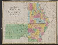
Creator:
Published / Created:
1833
Call Number:
80 1833
Container / Volume:
BRBL_00532
Image Count:
1
Resource Type:
Maps, Atlases & Globes
Description:
Includes population table.
Publisher:
S. Augustus Mitchell,
Subject (Geographic):
Arkansas--Maps and Missouri--Maps
Subject (Name):
Young, J. H. (James Hamilton)
Found in:
Beinecke Rare Book and Manuscript Library > Map of the state of Missouri and territory of Arkansas / compiled from the latest authorities ; J.H. Young, sc.
Published / Created:
April 15, 1832.
Call Number:
816 1832
Container / Volume:
BRBL_00561
Image Count:
1
Resource Type:
Maps, Atlases & Globes
Alternative Title:
Missouri and Illinois [cartographic material] and The states of Missouri and Illinois [cartographic material]
Publisher:
Published ... by I.T. Hinton & Simpkin & Marshall,
Subject (Geographic):
Illinois--Maps and Missouri--Maps
Subject (Name):
Fenner, Sears & Co, Hinton, Isaac Taylor, 1799-1847, and Simpkin and Marshall
Found in:
Beinecke Rare Book and Manuscript Library > Map of the states of Missouri and Illinois / engraved & printed by Fenner Sears & Co.
Creator:
Published / Created:
[1831]
Call Number:
816 1831
Container / Volume:
BRBL_00561
Image Count:
1
Resource Type:
Maps, Atlases & Globes
Description:
From Finley's A new general atlas. 1831.
Publisher:
A. Finley,
Subject (Geographic):
Missouri--Maps
Subject (Name):
Finley, A. (Anthony). A new general atlas and Young & Delleker
Found in:
Beinecke Rare Book and Manuscript Library > Missouri / Young & Delleker sc.
Creator:
Published / Created:
[1940]
Call Number:
816gmb 1940
Container / Volume:
BRBL_00564
Image Count:
2
Resource Type:
Maps, Atlases & Globes
Description:
Includes index, text, col. ill., and insets of Kansas City and St. Louis areas.
Publisher:
Missouri State Highway Commission,
Subject (Geographic):
Missouri--Maps
Subject (Topic):
Roads--Missouri--Maps
Found in:
Beinecke Rare Book and Manuscript Library > Missouri : 1940 highway map / compliments Missouri State Highway Commission.