
You Searched For
« Previous
| 1 - 10 of 13 |
Next »
Search Results
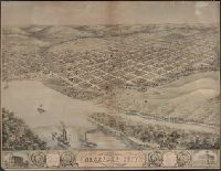
2.
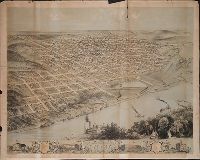
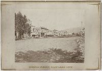
- Creator:
- Ruger, A., artist
- Published / Created:
- [1868]
- Call Number:
- BrSides Zc37 868ru
- Image Count:
- 1
- Resource Type:
- cartographic image
- Description:
- BEIN BrSides Zc37 868ru: Imperfect: 20 cm tear from top edge; On sheet 61 x 76 cm.
- Publisher:
- Chicago Lithographing Co.
- Subject (Geographic):
- Omaha (Neb.), Nebraska, and Omaha.
- Found in:
- Beinecke Rare Book and Manuscript Library > Bird's eye view of the city of Omaha, Nebraska 1868 [cartographic material]
3.

- Creator:
- George W. Williams & Company
- Published / Created:
- ca. 1869]
- Call Number:
- WA Photos 106
- Image Count:
- 58
- Abstract:
- Viewbook of mounted photographic prints compiled by the George W. Williams & Company, fertilizer merchants, ca. 1869. A photographic print appears on the recto of each mount that depicts an advertisement for Carolina Fertilizer with a letterpress tes...
- Description:
- Title from cover.
- Publisher:
- s.n.
- Subject (Geographic):
- United States., West (U.S.), Coalville (Utah), Echo (Utah), Laramie (Wyo.), Missouri River, Nebraska, Omaha (Neb.), Salt Lake City (Utah), Utah, Weber River Valley (Utah), and Wyoming
- Subject (Name):
- Russell, Andrew J., Williams, George Walton, 1820-1903., Young, Brigham, 1801-1877, Beehive House (Salt Lake City, Utah), Central Pacific Railroad Company, Lion House (Salt Lake City, Utah), Tabernacle (Salt Lake City, Utah), and Union Pacific Railroad Company
- Subject (Topic):
- Homes and haunts, Advertising, Agriculture, Fertilizer industry, and Railroads
- Found in:
- Beinecke Rare Book and Manuscript Library > Geo. W. Williams & Co.'s Carolina fertilizer, with twenty photographic views from the line of the Union Pacific Railroad
4.
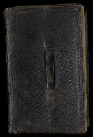
- Creator:
- Smith, Lucas F.
- Call Number:
- WA MSS S-2185
- Image Count:
- 734
- Abstract:
- Nine pocket diaries from the years 1867, 1868, 1871-1872, 1874-1875, 1877-1878, and 1880, containing brief holograph entries documenting Smith's activities as a law student at the University of Michigan; his early involvement in organizing clubs for y...
- Description:
- Lucas F. Smith was born ca. 1840 in Wells County, Indiana. He apprenticed as a printer in 1859, and was a member of Company G of the 101st Indiana Volunteer Infantry between 1863 and 1865. After graduating from the University of Michigan Law Departm...
- Subject (Geographic):
- Michigan., Texas., Ann Arbor (Mich.), Bonham (Tex.), Buffton (Ind.), Dallas (Tex.), Colorado, New Mexico, Nebraska, New York (State), Sherman (Tex.), Saint Louis (Mo.), and Texas
- Subject (Name):
- Brown, Thomas J., Cheneworth, J. A., Preston, Ja. (James), Smith, Joseph, 1870-1940., Smith, Lucas F., Smith, Zachary, fl. 1870., Throckmorton, J. W. 1825-1894. (James Webb),, Waddell, Joseph W., Democratic Party (U.S.), Texas. District Court (11th Judicial District), and University of Michigan. Department of Law.
- Subject (Topic):
- Students, Lawyers, Public prosecutors, Social life and customs, and Description and travel
- Found in:
- Beinecke Rare Book and Manuscript Library > Lucas F. Smith diaries and notebooks, 1863-1880
5.
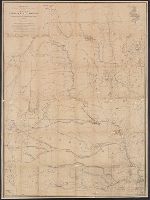
- Creator:
- Warren, G. K. (Gouverneur Kemble), 1830-1882, cartographer
- Published / Created:
- March, 1867.
- Call Number:
- 824 1867
- Image Count:
- 1
- Resource Type:
- cartographic image
- Alternative Title:
- Nebraska and Dakota
- Description:
- BEIN WA MSS S-1290: Dissected and mounted on linen. Inscription of William E. Merrill, dated May 20th, 1869, with annotations showing the position and size of Indian reservations and underlining of the printed names of military posts. Inscriptions on ...
- Publisher:
- Engineer Department, U.S. Army and J. Bien, lith., 24 Vesey St.
- Subject (Geographic):
- West North Central States, Nebraska, Dakota Territory, Nebraska., United States, Dakota Territory., and West North Central States.
- Subject (Topic):
- Indians of North America
- Found in:
- Beinecke Rare Book and Manuscript Library > Map of Nebraska and Dakota and portions of the states and territories bordering thereon
6.
- Creator:
- Russell, Andrew J.
- Published / Created:
- ca. 1867-1869.
- Call Number:
- WA Photos 192
- Container / Volume:
- Album
- Image Count:
- 58
- Abstract:
- Photographic prints of images created by Andrew Joseph Russell of locations in Utah, Wyoming, California, and Nebraska, ca. 1867-1869. The bound album contains the same images represented in the loose photographic prints. the loose photographic print...
- Description:
- Title devised by cataloger.
- Subject (Geographic):
- Utah, Salt Lake City., West (U.S.), Bear River (Utah-Idaho), Buford (Wyo.), California, Coalville (Utah), Dale Creek (Colo. and Wyo.), Donner Lake (Calif.), Dutch Flat (Calif.), Echo (Utah), Echo Canyon (Utah), Green River (Wyo.-Utah), Green River Valley (Wyo.-Utah), Grizzly Peak (Wyo.), Henefer (Utah), Laramie Basin (Wyo.), Laramie Mountains (Colo. and Wyo.), Laramie River (Colo. and Wyo.), Nebraska, North Platte River, One Thousand Mile Tree (Utah : Tree), Parley Canyon (Utah), Platte River (Neb.), Promontory (Utah), Salt Lake City (Utah), Sherman (Wyo.), Sierra Nevada (Calif. and Nev.), Temple Street (Salt Lake City, Utah), Uinta Mountains (Utah and Wyo.), Wasatch Range (Utah and Idaho), Weber River (Utah), Weber River Valley (Utah), White Pine Canyon (Summit County, Utah), Wilhelmina Pass (Utah), Witch Rocks (Utah), and Wyoming
- Subject (Name):
- Russell, Andrew J., Young, Brigham, 1801-1877, Beehive House (Salt Lake City, Utah), Lion House (Salt Lake City, Utah), Salt Lake Theatre, Tabernacle (Salt Lake City, Utah), Union Pacific Railroad Company, and Zion's Co-operative Mercantile Institution
- Subject (Topic):
- Homes and haunts, Bridges, Wooden, Hot springs, and Railroads
- Found in:
- Beinecke Rare Book and Manuscript Library > Photograph albums of Utah, Wyoming, Nebraska, and California
7.
- Creator:
- Russell, Andrew J.
- Published / Created:
- ca. 1867-1869.
- Call Number:
- WA Photos 192
- Container / Volume:
- Prints (in box)
- Image Count:
- 50
- Abstract:
- Photographic prints of images created by Andrew Joseph Russell of locations in Utah, Wyoming, California, and Nebraska, ca. 1867-1869. The bound album contains the same images represented in the loose photographic prints. the loose photographic print...
- Description:
- Title devised by cataloger.
- Subject (Geographic):
- Utah, Salt Lake City., West (U.S.), Bear River (Utah-Idaho), Buford (Wyo.), California, Coalville (Utah), Dale Creek (Colo. and Wyo.), Donner Lake (Calif.), Dutch Flat (Calif.), Echo (Utah), Echo Canyon (Utah), Green River (Wyo.-Utah), Green River Valley (Wyo.-Utah), Grizzly Peak (Wyo.), Henefer (Utah), Laramie Basin (Wyo.), Laramie Mountains (Colo. and Wyo.), Laramie River (Colo. and Wyo.), Nebraska, North Platte River, One Thousand Mile Tree (Utah : Tree), Parley Canyon (Utah), Platte River (Neb.), Promontory (Utah), Salt Lake City (Utah), Sherman (Wyo.), Sierra Nevada (Calif. and Nev.), Temple Street (Salt Lake City, Utah), Uinta Mountains (Utah and Wyo.), Wasatch Range (Utah and Idaho), Weber River (Utah), Weber River Valley (Utah), White Pine Canyon (Summit County, Utah), Wilhelmina Pass (Utah), Witch Rocks (Utah), and Wyoming
- Subject (Name):
- Russell, Andrew J., Young, Brigham, 1801-1877, Beehive House (Salt Lake City, Utah), Lion House (Salt Lake City, Utah), Salt Lake Theatre, Tabernacle (Salt Lake City, Utah), Union Pacific Railroad Company, and Zion's Co-operative Mercantile Institution
- Subject (Topic):
- Homes and haunts, Bridges, Wooden, Hot springs, and Railroads
- Found in:
- Beinecke Rare Book and Manuscript Library > Photograph albums of Utah, Wyoming, Nebraska, and California
8.

- Published / Created:
- 1892.
- Call Number:
- WA PHOTOS 297
- Image Count:
- 98
- Abstract:
- Snapshots of a westward rail journey in 1892, possibly taken by someone traveling with a group of Freemasons. Men in masonic caps and regalia appear in several of the images, and one is captioned "Group of citizens (at Station to see Sir Kts.)". The p...
- Description:
- Photographer unidentified.
- Subject (Geographic):
- United States, West (U.S.), Missouri river, Niagara Falls (N.Y.), Pullman (Chicago, Ill.), Omaha (Neb.), Nebraska, Iowa, Colorado, Glenwood Springs (Colo.), Gunnison (Colo.), and Marshall Pass (Colo.)
- Subject (Topic):
- Railroads, Railroad travel, Freemasons, Travelers, Railroad stations, Railroad bridges, Frontier and pioneer life, and Prairies
- Found in:
- Beinecke Rare Book and Manuscript Library > Photographs of a railroad trip from Niagara Falls to Colorado
9.
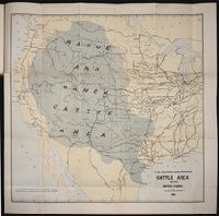
- Published / Created:
- 1884
- Call Number:
- Zc10 885up
- Collection Title:
- Range and ranch cattle
- Image Count:
- 1
- Resource Type:
- Maps, Atlases & Globes
- Description:
- Verso blank.
- Subject (Geographic):
- Arizona, Colorado, Dakota Territory, Idaho, Kansas, Montana, Nebraska, Nevada, New Mexico, Oregon, Texas, Utah, Washington (State), and Wyoming
- Subject (Name):
- Nimmo, Joseph, 1837-1909
- Subject (Topic):
- Cattle --West (U.S.) and Ranches --West (U.S.)
- Collection Created:
- [Washington : Govt. Print. Off., 1885]
- Found in:
- Beinecke Rare Book and Manuscript Library > The range and ranch cattle area of the United States
10.
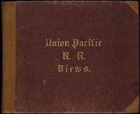
- Creator:
- Russell, Andrew J.
- Published / Created:
- ca. 1867-1869]
- Call Number:
- WA Photos 348
- Image Count:
- 35
- Abstract:
- Bound volume of mounted photographs by Andrew J. Russell that document the landscape views and buildings along the Union Pacific Railroad in Nebraska, Wyoming, and Utah, ca. 1867-1869. Many images of landscapes include men and women posited in the te...
- Description:
- Title from cover.
- Publisher:
- A. Mudge & Son Print
- Subject (Geographic):
- West (U.S.), Echo (Utah), Echo Canyon (Utah), Fort Sanders (Wyo.), Green River Valley (Wyo.-Utah), Missouri River, Nebraska, Omaha (Neb.), Salt Lake City (Utah), Utah, Weber River Valley (Utah), and Wyoming
- Subject (Name):
- Dillon, Sidney, 1812-1892, Grant, Ulysses S. 1822-1885 (Ulysses Simpson),, Russell, Andrew J., Sheridan, Philip Henry, 1831-1888, Sherman, William T. 1820-1891 (William Tecumseh),, Young, Brigham, 1801-1877, Beehive House (Salt Lake City, Utah), Lion House (Salt Lake City, Utah), Salt Lake Temple, Tabernacle (Salt Lake City, Utah), and Union Pacific Railroad Company
- Subject (Topic):
- Homes and haunts and Railroads
- Found in:
- Beinecke Rare Book and Manuscript Library > Union Pacific Railroad views