1.

- Creator:
- Ransom, Leander, 1800-1874
- Published / Created:
- 1863
- Call Number:
- 844 1863
- Container / Volume:
- BRBL_00602
- Image Count:
- 1
- Resource Type:
- Maps, Atlases & Globes
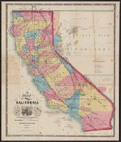
- Description:
- "Entered according to act of Congress in the year 1863 by Warren Holt ....", Includes distance table and index to land districts., Relief shown by hachures., Shows drainage, townships, mining districts, etc., and Unlike another variant, this does not contain statement "Lith. by L. Nagel," and has other variations including name "Arizona Ter." in lower right margin.
- Publisher:
- W. Holt,
- Subject (Geographic):
- California--Maps and Nevada--Maps
- Subject (Name):
- Doolittle, A. J and Holt, Warren
- Subject (Topic):
- Mining districts--California--Maps and Mining districts--Nevada--Maps
- Found in:
- Beinecke Rare Book and Manuscript Library > A new map of the state of California and Nevada Territory : exhibiting the rivers, lakes, bays and islands, with the principal towns, roads, railroads, and transit routes to the silver mining districts of Nevada Territory ... / carefully compiled ... by L