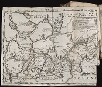
The American military pocket atlas : being an approved collection of correct maps, both general and
Image Count:
1
Alternative Title:
The Seat of war, in the northern colonies, containing the province of Quebec, Newfoundland, Nova-Scotia, New-England, New-York, New-Jersey, Pennsylvania, &ca
Description:
14th August 1776.
Publisher:
Printed for Robt. Sayer & Jno. Bennett, Map and Sea Chartsellers, No. 53, Fleet Street, as the Act directs
Subject (Geographic):
New England --Maps --Early works to 1800, North America --Maps --Early works to 1800, and United States --History --Revolution, 1775-1783 --Maps
Collection Created:
London : Printed for R. Sayer and J. Bennet, [1776]
The American atlas; or, A geographical description of the whole continent of America; wherein are
Image Count:
1
Resource Type:
Maps, Atlases & Globes
Description:
Stamped on verso: 16.
Subject (Geographic):
America --Maps --Early works to 1800, Connecticut --Maps --Early works to 1800, Massachusetts --Maps --Early works to 1800, New England --Maps --Early works to 1800, and Rhode Island --Maps --Early works to 1800
An historical, geographical, commercial, and philosophical view of the American United States, and
Image Count:
1
Description:
Engraved by Russell, Constitution R., Grays Inn La.
Publisher:
Publish'd as the Act directs, by H.D. Symonds, No. 20 Pater Noster Row
Subject (Geographic):
America --Description and travel, America --History --To 1810, New England --Maps --Early works to 1800, United States --Description and travel, and United States --Maps --Early works to 1800
Collection Created:
London, Printed for the editor; J. Ridgway [etc.] 1795
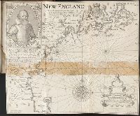
With engraved portrait of John Smith in upper left corner.
Description:
From an original drawn by Robert Clerke, Simon Paseus (?), lithographer, printed in London by Geor. Low.
Publisher:
Pendleton's Lithography
Subject (Geographic):
Massachusetts --History --Colonial period, ca. 1600-1775, Massachusetts --Maps --Early works to 1800, New England --Description and travel, New England --History --Colonial period, ca. 1600-1775, and New England --Maps --Early works to 1800
Subject (Name):
Clarke, Robert, fl. 1616
Collection Created:
London, Printed by I. Haviland, and are to be sold by R. Milbovrne, 1631