"June 30 1891.", Inset: St. Croix River and N. E. Boundary, 1:600,000., and Top margin: "Coast and Geodetic Survey, Report for 1891" ; "Plate No. 1166" ; "No. 7."
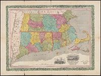
Horace Thayer & Co.'s map of Mass., Conn. & R.I. and Railroad & township map of Massachusetts, Connecticut and Rhode Island
Description:
Borders of counties in red, yellow, green and blue; borders of Connecticut and Rhode Island in red., Cover title: Horace Thayer & Co.'s map of Mass., Conn. & R.I., In purplish black cloth covered folder with gold title within decorative border., and Includes vig
Publisher:
Thayer, Bridgman & Fanning,
Subject (Geographic):
Connecticut--Maps, Massachusetts--Maps, New England--Maps, New York (State)--Maps, and Rhode Island--Maps
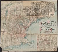
"The Matthews-Northrup Works, Buffalo, Cleveland, New York.", 3 inset maps affixed to sheet., Inset: The "American Switzerland" as reached by the Boston & Maine R.R. Scale [ca. 1:370,000]., and Relief shown by shading and spot heights.
Publisher:
Matthews-Northrup Works,
Subject (Geographic):
New England--Maps
Subject (Name):
Boston and Maine Railroad--Maps and Matthews-Northrup Works
On verso: Local area maps showing locations of "Real Tour hotels": Albany, N.Y. -- Briarcliff Manor, N.Y. -- Greenfield, Mass. -- Hartford, Conn. -- New Haven, Conn. -- Pittsfield, Mass. -- Pough and On verso: Map of Berkshire County, Mass. and mileage table.
Publisher:
Automobile Club of America,
Subject (Geographic):
Berkshire Hills (Mass.)--Maps and New England--Maps
Subject (Topic):
Hotels--Massachusetts--Berkshire Hills--Maps, Hotels--New England--Maps, Roads--Massachusetts--Berkshire Hills--Maps, and Roads--New England--Maps
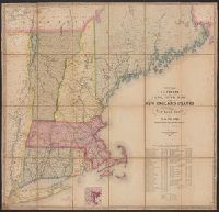
Telegraph and rail road map of the New England states, eastern portion of New York state and Canada
Description:
Entered according to act of Congress, in the year 1852, by Redding & Co. in the clerk's office of the District court of the United States for the district of Massachusetts. and Includes table showing the "cost of construction and equipment of all the rail roa