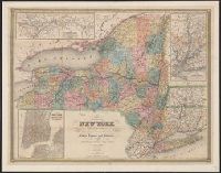
McAlpine, William J. (William Jarvis) Vaughan, David, fl. 1849-1864
Call Number:
771gm 1854
Container / Volume:
BRBL_00494
Image Count:
1
Resource Type:
Maps, Atlases & Globes
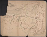
Description:
Also shows lakes, canals, drainage and county boundaries as well as adjacent portions of neighboring states and provinces., Imperfect: mutilated with loss of text., and Relief shown by hachures.
Publisher:
s.n.],
Subject (Geographic):
New York (State), New York (State)--Administrative and political divisions--Maps., and New York (State)--Maps
Subject (Name):
Gavit, John E., 1817-1874, Smith, David--Autograph., and Vaughan, David, active 1849-1864
Subject (Topic):
Administrative and political divisionsCanalsCanals--New York (State)--Maps and RailroadsRailroads--New York (State)--Maps
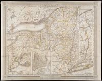
McAlpine, William J. (William Jarvis) Vaughan, David, fl. 1849-1864
Call Number:
771gm 1854
Container / Volume:
BRBL_00494
Image Count:
1
Resource Type:
Maps, Atlases & Globes
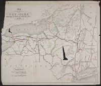
Description:
Also shows lakes, canals, drainage and county boundaries as well as adjacent portions of neighboring states and provinces., Imperfect: mutilated with loss of text., and Relief shown by hachures.
Publisher:
s.n.],
Subject (Geographic):
New York (State), New York (State)--Administrative and political divisions--Maps., and New York (State)--Maps
Subject (Name):
Gavit, John E., 1817-1874, Smith, David--Autograph., and Vaughan, David, active 1849-1864
Subject (Topic):
Administrative and political divisionsCanalsCanals--New York (State)--Maps and RailroadsRailroads--New York (State)--Maps
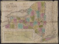
1 inch = ca. 20 miles., Colored by county, with border of New York in magenta., and In leather-covered folder with "New-York" gold-stamped within decorative gold border and table of populations of counties in 1820 and 1830 and populations of county towns in 183
Publisher:
Case & Waters,
Subject (Geographic):
Erie Canal (N.Y.)--Maps., Hudson River (N.Y. and N.J.)--Maps., New York (State), New York (State)--Erie Canal, New York (State)--Maps, and United States--Hudson River
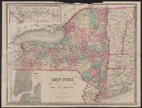
Also covers Vermont, Connecticut, and part of New Jersey, New Hampshire & Massachusetts., Includes legend., Insets: The St. Lawrence River, from the New York state line to Quebec -- City of New York, with part of Brooklyn and Williamsburgh., and Prime meridians:
Publisher:
J. Disturnell,
Subject (Geographic):
New York (State), New York (State)--Administrative and political divisions--Maps., and New York (State)--Maps.
Subject (Name):
Disturnell, John, 1801-1877 and Sherman & Smith
Subject (Topic):
Administrative and political divisions, Canals, Canals--New York (State)--Maps., Railroads, and Railroads--New York (State)--Maps.
City of New York, with part of Brooklyn and Williamsburg, New-York State guide., St. Lawrence River, from the New York state line to Quebec, and Vicinity of New York, showing the line of the Croton Aqueduct and the Hudson River to Newburg
Description:
"Entered according to Act of Congress in the year 1842 by J. Calvin Smith in the Clerk's Office of the District Court of the southern District of New York." and In: The New-York State guide : containing an alphabetical list of counties, towns, cities, village
Publisher:
J. Disturnell,
Subject (Geographic):
Croton Aqueduct (N.Y.)--Maps., New York (N.Y.)--Maps, New York (State), New York (State)--Croton Aqueduct, New York (State)--Maps, New York (State)--New York, and North America--Saint Lawrence
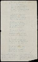
Autograph manuscript, signed, by "H. A. L." containing lines from Lucy Smith's Moroni's Lamentation (a Mormon hymn given to Smith in 1833 and sung in the Nephite tongue), undated but possibly created during the 19th century. The manuscript does not follow the original hymn entirely as it includes variations and additions. The hymn has reference to a battle of the Nephites against the Lamanites around the Hill Cumorah in New York State
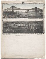
Two images of New York's East River are enclosed in a leafy scroll-like border. The upper image shows the Brooklyn Bridge spanning the river, with a large side-wheel steamboat in the middle of the river and numerous buildings crowded thickly on the Manhattan shore. The lower image shows a large number of sailboats, clippers, and one steamer in the river, with Brooklyn's built-up environs in the background
Alternative Title:
East River front
Description:
BEIN WA Prints 424: Partially hand-colored., Title from caption below image., and Date suggested by James Milgram. See Milgram, James W., "Illustrated letter stationery of New York City," in Postal history journal, no. 164, June 2016, page 29.
Publisher:
Charles Magnus, publisher
Subject (Geographic):
East River (N.Y.), New York (N.Y.), Brooklyn Bridge (New York, N.Y.), New York (State), and New York