Skip to search
Skip to main content
Skip to first result
Search
You Searched For
Subject (Geographic)
New York (State)--Maps
Search Results
Published / Created:
1861
Call Number:
771fab 1861
Container / Volume:
BRBL_00493
Image Count:
6
Resource Type:
Maps, Atlases & Globes
Alternative Title:
Map shewing the positions of Boundary Lines between New York & Connecticut.
Publisher:
Lith. C. Van Benthuysen,
Subject (Geographic):
New York (State)--Maps
Found in:
Beinecke Rare Book and Manuscript Library > Map of the boundary line between the states of New York and Connecticut, to accompany the report of the New York Commissioners/ H.S. Dewy, Engineer, John Evans, Assistant.
Creator:
Weed, Parsons & Co
Published / Created:
1880
Call Number:
771gme 1880
Container / Volume:
BRBL_00494
Image Count:
2
Resource Type:
Maps, Atlases & Globes
Description:
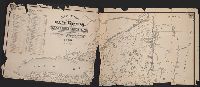
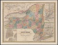
Also shows drainage, canals and county boundaries.
Publisher:
Lith. by Weed, Parsons & Co.,
Subject (Geographic):
New York (State)--Administrative and political divisions--Maps and New York (State)--Maps
Subject (Name):
Seymour, Horatio, 1810-1886 and Smalley, Edward D
Subject (Topic):
Canals--New York (State)--Maps and Railroads--New York (State)--Maps
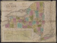
Found in:
Beinecke Rare Book and Manuscript Library > Map of the railroads of the State of New York / prepared under the direction of Horatio Seymour Jr., State Engr. & Surveyor, Edward D. Smalley, Deputy State Engr. & Survr.
Published / Created:
1889
Call Number:
771gme 1889
Container / Volume:
BRBL_00494
Image Count:
2
Resource Type:
Maps, Atlases & Globes
Publisher:
Weed, Parsons & Co.,
Subject (Geographic):
New York (State)--Maps
Found in:
Beinecke Rare Book and Manuscript Library > Map of the railroads of the State of New York to accompany the report of the State Board of Railroad Commissioners, 1889.
Creator:
Case & Waters.
Published / Created:
1834
Call Number:
771 1834
Container / Volume:
BRBL_00478
Image Count:
1
Resource Type:
Maps, Atlases & Globes
Alternative Title:
New-York
Description:
1 inch = ca. 20 miles.
Publisher:
Case & Waters,
Subject (Geographic):
Erie Canal (N.Y.)--Maps., Hudson River (N.Y. and N.J.)--Maps., New York (State), New York (State)--Erie Canal, New York (State)--Maps, and United States--Hudson River
Found in:
Beinecke Rare Book and Manuscript Library > Map of the state of New York [cartographic material] : from the best authorities / published by Case & Waters, Hartford, Ct.
Published / Created:
1912
Call Number:
771gm 1912
Container / Volume:
BRBL_00494
Image Count:
1
Resource Type:
Maps, Atlases & Globes
Description:
Inset: Terminal locations in New York City.
Subject (Geographic):
New York (State)--Maps
Found in:
Beinecke Rare Book and Manuscript Library > Map of the state of New York showing locations of Barge Canal Terminals/ to accompany the annual report of the state engineer and surveyor.
Creator:
Phelps, Humphrey
Published / Created:
1832
Call Number:
771 1833
Container / Volume:
BRBL_00478
Image Count:
1
Resource Type:
Maps, Atlases & Globes
Alternative Title:
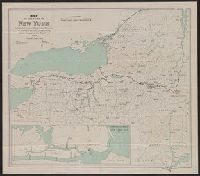
Profile of the northern canal and Profile of the western canal, H. Phelps, New York, 1832
Description:
Below title is lo
Publisher:
Humphrey Phelps,
Subject (Geographic):
Champlain Canal (N.Y.)--Maps, Erie Canal (N.Y.)--Maps, and New York (State)--Maps
Subject (Topic):
Canals--New York (State)--Maps
Found in:
Beinecke Rare Book and Manuscript Library > Map of the state of New York with the latest improvements / by H. Phelps.
Creator:
Smith, J. Calvin (John Calvin)
Call Number:
771 1842
Container / Volume:
BRBL_00478
Image Count:
1
Resource Type:
Maps, Atlases & Globes
Alternative Title:
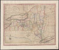
City of New York, with part of Brooklyn and Williamsburg, New-York State guide., St. Lawrence River, from the New York state line to Quebec, and Vicinity of New York, showing the line of the Croton Aqueduct and the Hudson River to Newburg
Description:
"Entered according to Act of Congress in the year 1842 by J. Calvin Smith in the Clerk's Office of the District Court of the southern District of New York."
Publisher:
J. Disturnell,
Subject (Geographic):
Croton Aqueduct (N.Y.)--Maps., New York (N.Y.)--Maps, New York (State), New York (State)--Croton Aqueduct, New York (State)--Maps, New York (State)--New York, and North America--Saint Lawrence
Subject (Name):
Disturnell, John, 1801-1877 and Sherman & Smith
Subject (Topic):
Railroads and Railroads--New York (State)--Maps
Found in:
Beinecke Rare Book and Manuscript Library > Map of the state of New York, showing the boundaries of counties & townships, the location of cities, towns and villages, the courses of rail roads, canals & state roads / by J. Calvin Smith ; engraved on steel by Sherman & Smith.
Creator:
Bien, Joseph R
Published / Created:
c1895.
Call Number:
771 1895D
Image Count:
1
Resource Type:
Maps, Atlases & Globes
Description:
From: Atlas of the state of New York. New York : Julius Bien & Co., 1895.
Publisher:
Julius Bien & Co.,
Subject (Geographic):
New York (State)--Maps
Subject (Name):
Julius Bien & Co
Found in:
Beinecke Rare Book and Manuscript Library > Map of the state of New York.
Published / Created:
c1919.
Call Number:
771gmb 1919
Container / Volume:
BRBL_00494
Image Count:
1
Resource Type:
Maps, Atlases & Globes
Publisher:
National Highway Association,
Subject (Geographic):
New York (State)--Maps
Found in:
Beinecke Rare Book and Manuscript Library > National Highway Map of the state of New York showing thirty-seven hundred miles of National highways.
Creator:
Wanamaker, John, 1838-1922
Published / Created:
c1917.
Call Number:
771gmb N49 1917
Container / Volume:
BRBL_00494
Image Count:
1
Resource Type:
Maps, Atlases & Globes
Description:
Mounted on linen. Imperfect.
Subject (Geographic):
New York (State)--Maps
Subject (Topic):
Roads--New York Metropolitan Area--Maps
Found in:
Beinecke Rare Book and Manuscript Library > New York & vicinity: The Wanamaker diary automobile road map.
Branch:v1.68.7 ,Deployed:2025-07-09T09:08:07-04:00