Skip to search
Skip to main content
Skip to first result
Search
You Searched For
Subject (Geographic)
New York (State)--Maps--Early works to 1800
Search Results
Published / Created:
1776
Call Number:
771 C358 1776C
Container / Volume:
BRBL_00482
Image Count:
1
Resource Type:
Maps, Atlases & Globes
Description:
Inset: A particular plan of Lake George. Surveyed in 1756 by Capt. Jackson. Scale [ca. 1:150 000].
Publisher:
Robt. Sayer & Jno. Bennett,
Subject (Geographic):
Champlain, Lake--Maps--Early works to 1800 and New York (State)--Maps--Early works to 1800
Subject (Name):
Robert Sayer and John Bennett (Firm)
Found in:
Beinecke Rare Book and Manuscript Library > A Survey of Lake Champlain including Lake George, Crown Point, and St. John ... by William Brassier, Draughtsman. 1762.
Published / Created:
1776
Call Number:
771 C358 1776
Container / Volume:
BRBL_00482
Image Count:
1
Resource Type:
Maps, Atlases & Globes
Description:
Inset: Lake George. Scale ca. 1:150 000
Publisher:
Map & Sea Chartsellers,
Subject (Geographic):
Champlain, Lake--Maps--Early works to 1800 and New York (State)--Maps--Early works to 1800
Found in:
Beinecke Rare Book and Manuscript Library > A Survey of Lake Champlain including Lake George, Crown Point, and St. John : surveyed by order of his Excellency major General Sr. Jeffery Amherst ... / by William Brassier, Draughtsman, 1762.
Creator:
Published / Created:
[1676]
Call Number:
755 1672A
Container / Volume:
BRBL_00423
Image Count:
2
Resource Type:
Maps, Atlases & Globes
Description:
Author statement from McCorkle, p. 40.
Publisher:
Sold by Tho: Basset in Fleetstreet, and Richard Chiswell in St. Pauls Church Yard,
Subject (Geographic):
New England--Maps--Early works to 1800 and New York (State)--Maps--Early works to 1800
Subject (Name):
Bassett, Thomas, bookseller, Chiswell, Richard, Lamb, Francis, and Speed, John, 1552?-1629. Prospect of the most famous parts of the world
Found in:
Beinecke Rare Book and Manuscript Library > A map of New England and New York / F. Lamb sculp.
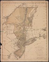
Published / Created:
1776
Call Number:
755 1776D
Container / Volume:
BRBL_00430
Image Count:
1
Resource Type:
Maps, Atlases & Globes
Description:
2 copies.
Publisher:
William Faden,
Subject (Geographic):
Canada--Maps--Early works to 1800 and New York (State)--Maps--Early works to 1800
Found in:
Beinecke Rare Book and Manuscript Library > A map of the Province of New York ... by Claude Joseph Sauthier ... New Jersey ... Engraved by Wm. Faden.
Creator:
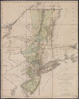
Published / Created:
1756
Call Number:
755 1765A
Container / Volume:
BRBL_00690
Image Count:
1
Resource Type:
Maps, Atlases & Globes
Alternative Title:
London magazine (London, England : 1732-1785)
Description:
"Engrav'd for the Lond. Mag."
Publisher:
Printed for R. Baldwin in Pater Noster Row,
Subject (Geographic):
New Jersey--Maps--Early works to 1800 and New York (State)--Maps--Early works to 1800
Found in:
Beinecke Rare Book and Manuscript Library > A map of the eastern part of the Province of New York : with part of New Jersey &c. / drawn from the best authorities by T. Kitchin geogr.
Creator:
Published / Created:
1777
Call Number:
73 1777
Container / Volume:
BRBL_00373
Image Count:
1
Resource Type:
Maps, Atlases & Globes
Alternative Title:
[American maps ; v. 3, no. 22], Canada from the French surveys with the frontiers of New York and New England., and Library of Congress. American maps ; v. 3, no. 22.
Description:
Relief shown pictorially and by hachures.
Subject (Geographic):
Canada--Boundaries--United States--Maps--Early works to 1800, New York (State)--Maps--Early works to 1800, Québec (Province)--Maps--Early works to 1800, and United States--History--Revolution, 1775-1783--British forces
Subject (Name):
Sauthier, Claude Joseph
Found in:
Beinecke Rare Book and Manuscript Library > A map of the inhabited part of Canada from the French surveys, with the frontiers of New York and New England; from the large survey by Claude Joseph Sauthier. Engraved by Wm. Faden, 1777.
Creator:
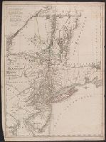
Published / Created:
[1673?]
Call Number:
755 1682B
Container / Volume:
BRBL_00424
Image Count:
1
Resource Type:
Maps, Atlases & Globes
Alternative Title:
Map of Virginia, Maryland, New Jersey, New-York & New England and Mapp of New England
Description:
"Separate publication ca. 1673 ... Various dates have been assigned to the map, from 1673 to 1685" (McCorkle 33).
Publisher:
By John Thornton ... and by Robert Greene ... ,
Subject (Geographic):
Middle Atlantic States--Maps--Early works to 1800, New England--Maps--Early works to 1800, and New York (State)--Maps--Early works to 1800
Subject (Name):
Green, Robert
Found in:
Beinecke Rare Book and Manuscript Library > A mapp of Virginia, Mary-land, New-Jarsey, New-York, & New England.
Creator:
Published / Created:
1778
Call Number:
771 1778S
Container / Volume:
BRBL_00729
Image Count:
1
Resource Type:
Maps, Atlases & Globes
Description:
"Beaublé scripsit."
Publisher:
Chez Le Rouge,
Subject (Geographic):
New York (State)--Maps--Early works to 1800
Found in:
Beinecke Rare Book and Manuscript Library > Carte des troubles de l'Amérique ... par Sauthier et Ratzer.
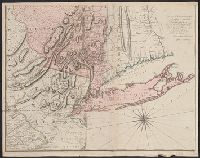
Published / Created:
1775
Call Number:
771 1775A
Container / Volume:
BRBL_00477
Image Count:
2
Resource Type:
Maps, Atlases & Globes
Description:
Captain Montresor, Engineer. P. Andrews Sculp.
Publisher:
A. Dury,
Subject (Geographic):
New York (State)--Maps--Early works to 1800
Found in:
Beinecke Rare Book and Manuscript Library > Map of the Province of New York with part of Pennsilvania and New England ...