Skip to search
Skip to main content
Skip to first result
Search
You Searched For
Subject (Geographic)
North America
Search Results
Call Number:
1975 Folio 14
Collection Title:
The Atlantic Neptune, published for the use of the Royal Navy of Great Britain. By Joseph F.W. Des
Image Count:
1
Resource Type:
Books, Journals & Pamphlets
Alternative Title:
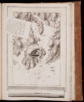
Egmont Harbor. pl. 21.
Publisher:
Published according to Act of parliament by J.F.W. Des Barres
Subject (Geographic):
North America
Subject (Topic):
Charts, diagrams, etc., Coasts, and Nautical charts.
Collection Created:
London, 1777-[81]
Found in:
Beinecke Rare Book and Manuscript Library > ...There is good and well sheltered anchorage without the harbor between Isle James and Isle Worth. Banks inlet leaves between the extensive dry flats at its entrance but a narrow and winding passage for the smallest fishing craft
Creator:
Published / Created:
1758.
Call Number:
2003 Folio 85
Image Count:
1
Alternative Title:
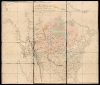
Middle British colonies
Description:
BEIN 2003 Folio 85: No. 17 of 45 maps bound together with binder's spine title: Atlas of America; ms. table of contents. Bookplate: Robinson. Bookplate of Paul Mellon.
Publisher:
Sold by T. Jefferys
Subject (Geographic):
Northeastern States, North America, and America
Subject (Topic):
British
Found in:
Beinecke Rare Book and Manuscript Library > A general map of the middle British colonies in America : viz. Virginia, Maryland, Delaware, Pensilvania, New-Jersey, New-York, Connecticut and Rhode-Island : of Aquanishuonigy the country of the confederate Indians comprehending Aquanishuonigy proper, their places of residence, Ohio and Thuchsochruntie their deer hunting countries, Couchsachrage and Skaniadarade their beaver hunting countries, of the Lakes Erie, Ontario and Champlain, and of part of New France: wherein is also shewn the antient and present seats of the Indian nations
Creator:
Published / Created:
[1820]
Call Number:
71 1820B
Image Count:
1
Resource Type:
cartographic image
Description:
BEIN 71 1820B: Dissected and mounted on linen.
Publisher:
Published Jan. 1, 1795 by A. Arrowsmith, No. 10 Soho Square
Subject (Geographic):
North America
Found in:
Beinecke Rare Book and Manuscript Library > A map exhibiting all the new discoveries in the interior parts of North America : inscribed by permission to the honorable governor and company of adventurers of England trading into Hudsons Bay, in testimony of their liberal communications to their most obedient and very humble servant, A. Arrowsmith, Hydrographer to His Majesty
Creator:
Published / Created:
1765.
Call Number:
2003 Folio 85
Image Count:
1
Description:
BEIN copy stamped on verso: Yale, Horace Brown, 1900S.
Publisher:
Printed for John Bowles
Subject (Geographic):
America and North America
Subject (Topic):
British
Found in:
Beinecke Rare Book and Manuscript Library > A map of North America
Creator:
Published / Created:
[1698]
Call Number:
Zc20 697heg
Collection Title:
Map [1]. New discovery of a vast country in America.
Image Count:
1
Resource Type:
cartographic image
Description:
Relief shown pictorially.
Publisher:
Printed for M. Bentley, J. Tonson, H. Bonwick, T. Goodwin, and S. Manship
Subject (Geographic):
North America, Mississippi River Valley, Mississippi River Valley., and North America.
Subject (Topic):
Maps
Found in:
Beinecke Rare Book and Manuscript Library > A map of a large country newly discovered in the Northern America situated between New Mexico and the frozen sea together with the course of the great river Meschasipi / [cartographic material]
Creator:
Published / Created:
MDCCXLVI [1746]
Call Number:
2003 Folio 85
Image Count:
1
Resource Type:
cartographic image
Description:
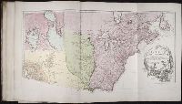
BEIN 2003 Folio 85: No. 2 of 45 maps bound together with binder's spine title: Atlas of America; ms. table of contents. Bookplate of Paul Mellon.
Publisher:
Chez l'auteur, aux Galeries du Louvre
Subject (Geographic):
North America
Found in:
Beinecke Rare Book and Manuscript Library > Amérique Septentrionale : publiée sous les auspices de Monseigneur le Duc d'Orleans prémier prince du sang / par le Sr. D'Anville
Creator:
Published / Created:
[between 1755 and 1775?]
Call Number:
2003 Folio 85
Image Count:
1
Description:
BEIN 2003 Folio 85: No. 4 of 45 maps bound together with binder's spine title: Atlas of America; ms. table of contents. Bookplate of Paul Mellon.
Publisher:
Printed for Robt. Sayer opposite Fetter Lane Fleet Street
Subject (Geographic):
North America
Found in:
Beinecke Rare Book and Manuscript Library > An accurate map of North America : describing and distinguishing the British, Spanish and French dominions on this great continent; exhibiting the present seat of war, and the French encroachments. Also all the West India Islands belonging to, and possessed by the several European princes and states. The whole laid down according to the latest and most authentick improvements
Creator:
Published / Created:
1852.
Call Number:
Ega 852Ta
Image Count:
190
Resource Type:
cartographic image
Alternative Title:
Atlas severozapadnykh beregov Ameriki ot Beringova proliva do mysa Korriėntes i ostrovov Aleutskikh s prisovokupleniem nekotorykh mest severovostochnago berega Azii, Атлас северозападных берегов Америки от Берингова пролива до мыса Корриэнтес и островов Алеутских с присовокуплением некоторых мест северовосточнoго берега Азии, Gidrograficheskīi︠a︡ zami︠e︡chanīi︠a︡ kʺ atlasu si︠e︡verozapadnykhʺ beregovʺ Ameriki, ostrovovʺ Aleutskikhʺ i ni︠e︡kotorykhʺ drugikhʺ mi︠e︡stʺ Si︠e︡vernago Tikhago okeana, Гидрографическія замѣчанія къ атласу сѣверозападныхъ береговъ Америки, острововъ Алеутскихъ и нѣкоторыхъ другихъ мѣст Сѣвернаго Тихаго океана, Gidrograficheskii︠a︡ zamechanii︠a︡ k atlasu severozapadnykh beregov Ameriki, ostrovov Aleutskikh i nekotorykh drugikh mest Severnogo Tikhogo okeana, and Гидрографическия замечания к атласу северозападных берегов Америки, островов Алеутских и некоторых других мест Севернoго Тихoго океана
Description:
BEIN EEga 852T: Printed label on inside front cover: Cat. [with manuscript 786].
Publisher:
publisher not identified
Subject (Geographic):
Alaska, California, Pacific Coast (North America)., Asia, Pacific Coast., Alaska., California., and North America
Subject (Topic):
Nautical charts
Found in:
Sterling Memorial Library > Atlasʺ si︠e︡verozapadnykhʺ beregovʺ Ameriki otʺ Beringova proliva do mysa Korrīėntesʺ i ostrovovʺ Aleutskikhʺ sʺ prisovokuplenīemʺ ni︠e︡kotorykhʺ mi︠e︡stʺ si︠e︡verovostochnago berega Azīi, Атласъ сѣверозападныхъ береговъ Америки отъ Берингова пролива до мыса Корріэнтесъ и острововъ Алеутскихъ съ присовокупленіемъ нѣкоторыхъ мѣстъ сѣверовосточнаго берега Азіи
Creator:
Published / Created:
c1981.
Call Number:
1982 Folio 22
Image Count:
14
Alternative Title:
Birds of America
Description:
At head of title: The Audubon Society baby elephant folio.
Publisher:
Abbeville Press
Subject (Geographic):
North America
Subject (Topic):
Birds and Artists
Found in:
Beinecke Rare Book and Manuscript Library > Audubon's Birds of America
Creator:
Published / Created:
Novembre MDCCLV [1755]
Call Number:
2003 Folio 85
Image Count:
1
Resource Type:
cartographic image
Description:
BEIN 2003 Folio 85: No. 3 of 45 maps bound together with binder's spine title: Atlas of America; ms. table of contents. Bookplate: Robinson. Bookplate of Paul Mellon.
Publisher:
Chez l'auteur, aux galeries du Louvre
Subject (Geographic):
North America, Louisiana, and Canada
Subject (Topic):
Maps
Found in:
Beinecke Rare Book and Manuscript Library > Canada, Louisiane et terres angloises