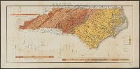
"Entered according to act of Congress in the 1855 by J.H. Colton & Co. ... for the Southern District of New York.", Imperfect: chipped and torn., Inset: Beaufort Harbor., Prime meridians: Greenwich and Washington., Relief shown by hachures and spot heights., and Shows counties, cities and towns, principal roads, railroads, and natural features. Colored to show tree types and mineral resources.
Publisher:
G.W. & C.B. Colton,
Subject (Geographic):
Beaufort (N.C.)--Maps, North Carolina--Beaufort, and North Carolina--Maps
Subject (Name):
J.H. Colton & Co
Subject (Topic):
Coal mines and mining--North Carolina--Maps, Copper mines and mining--North Carolina--Maps, Forests and forestry--North Carolina--Maps, Gold mines and mining--North Carolina--Maps, and Iron mines and mining--North C
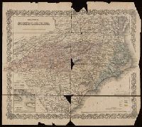
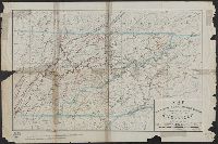
"Entered according to Act of Congress in the year 1883 by G.W. & C.B. Colton ...", In upper left and right margins: No. 45, No. 46., Includes 2 insets: Beaufort Harbor -- Plan of Charleston, vicinity and harbor., Relief shown by hachures and spot heights., and Sh
Publisher:
G.W. and C.B. Colton & Co.,
Subject (Geographic):
North Carolina--Maps and South Carolina--Maps
Subject (Name):
Colton, G. Woolworth (George Woolworth), 1827-1901 and Kerr, Washington Caruthers, 1827-1885
Subject (Topic):
Railroads--North Carolina--Maps and Railroads--South Carolina--Maps
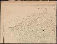
New topographical map of the eastern portion of the state of North Carolina
Description:
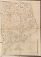
At upper left corner, outside margin & foliate border: No. 11., Cut into 2 sheets, Inset map: Plan of the, Prime meridans: Greenwich and Washington, D.C., Relief shown by hachures., and Shows names of counties, cities, towns, roads, railroads, rivers, and inlets.
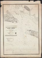
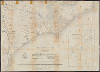
"May 1862.", Does not show military operations., Includes "Table of sounding and tides as given in the U.S.C.S. reports of 1855 & 1857.", and Indicates coastal fortifications, roads, railroads, drainage, canals, swamps, and towns.
Publisher:
The Bureau?,
Subject (Geographic):
North Carolina--History--Civil War, 1861-1865--Maps, North Carolina--Maps, and United States--History--Civil War, 1861-1865--Maps
"May 1862.", Does not show military operations., Includes "Table of sounding and tides as given in the U.S.C.S. reports of 1855 & 1857.", Indicates coastal fortifications, roads, railroads, drainage, canals, swamps, and towns., and Lower half of map only.
Publisher:
The Bureau?,
Subject (Geographic):
North Carolina--History--Civil War, 1861-1865--Maps, North Carolina--Maps, and United States--History--Civil War, 1861-1865--Maps
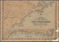
Decorative border., From Johnson's new illustrated family atlas of the world. New York : A.J. Johnson, 1866., Includes 2 inset views: Chimney Rocks and French Broad River -- Table Mountain., Includes inset: Map of Charleston Harbor., and Prime meridians: Greenwic
Publisher:
Johnson & Ward,
Subject (Geographic):
North Carolina--Maps and South Carolina--Maps
Subject (Name):
Johnson, A. J. (Alvin Jewett), 1827-1884
Subject (Topic):
Railroads--North Carolina--Maps, Railroads--South Carolina--Maps, Roads--North Carolina--Maps, and Roads--South Carolina--Maps