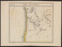
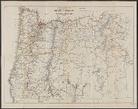
Appears in the author's Atlas universel de géographie physique, politique, statistique et minéralogique. 1827., In top margin: Amer. sep. ... no 38., and Relief shown by hachures.
Publisher:
P. Vandermaelen,
Subject (Geographic):
Oregon--Maps, Pacific Coast (Or.)--Maps, Pacific Coast (Wash.)--Maps, and Washington (State)--Maps
Subject (Name):
Arnold, Robert M.--Ownership and Vandermaelen, Philippe, 1795-1869. Atlas universel de géographie physique, politique, statistique et minéralogique
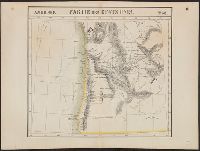
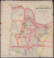
Appears in the author's Atlas universel de géographie physique, politique, statistique et minéralogique. 1827., Covers coastal Oregon and southern coastal Washington., In top margin: Amér. sep. ... no 38., and Relief shown by hachures.
Publisher:
P. Vandermaelen,
Subject (Geographic):
Oregon--Maps, Pacific Coast (Or.)--Maps, Pacific Coast (Wash.)--Maps, and Washington (State)--Maps
Subject (Name):
Arnold, Robert M.--Ownership and Vandermaelen, Philippe, 1795-1869. Atlas universel de géographie physique, politique, statistique et minéralogique
Trutch, Joseph W. (Joseph William), Sir, 1826-1904
Published / Created:
1856
Call Number:
846 1856
Image Count:
2
Resource Type:
Maps, Atlases & Globes
Alternative Title:
Preston's map of Oregon & Washington Territories, 1856
Description:
"Entered according to act of Congress in the year 1856, J.A. Preston, in the clerk's office of the district court of the United States, for the northern district of Illinois." and Library's copy 1 in case 19 x 13 cm. Copy 2 without covers, and dissected and mounted on linen, in 2 sheets (84 x 60 cm. and 79 x 60 cm.)
Publisher:
A.H. Burley, Stationer,
Subject (Geographic):
Oregon--Maps and Washington (State)--Maps
Subject (Name):
Burley, A. H, Ferd. Mayer & Co, Hyde, G. W, and Preston, J. A. (John A.)
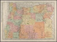
Road map of Oregon, Washington and Washington, Oregon
Description:
"1-463683-6.", "Rand McNally road map, United States" (scale [ca. 1:10,200,960]),text, ill., and distance table on verso., Indexed., and Relief shown pictorially and by spot heights.
Publisher:
Rand McNally ; and Randall Motor Club [distributor?],
Subject (Geographic):
Oregon--Maps, United States--Maps, and Washington (State)--Maps
Subject (Name):
Randall Motor Club
Subject (Topic):
Roads--Oregon--Maps, Roads--United States--Maps, and Roads--Washington (State)--Maps
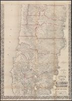
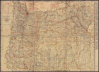
Includes text on "terms and conditions" for sale of railroad land by P. Schulze for Oregon & California Railroad., Portrays "land sold since Aug. 1st, 1877.", and Shows counties, surveyed section lines, towns, railroads, rivers, and military and railroad grants.
Publisher:
Rand, McNally and Co.,
Subject (Geographic):
Oregon--Maps
Subject (Name):
Oregon and California Railroad Company
Subject (Topic):
Land grants--Oregon--Maps, Railroads--Oregon--Maps, and Real property--Oregon--Maps