Skip to search
Skip to main content
Skip to first result
Search
You Searched For
Subject (Geographic)
Peru--Maps
New Search
Search Results
Creator:
Published / Created:
1903
Call Number:
97 1903A
Container / Volume:
BRBL_00677
Image Count:
2
Resource Type:
Maps, Atlases & Globes
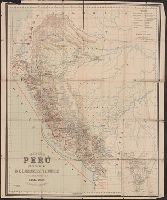
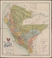
Abstract:
Map shows major methods of communication and transportation.
Description:
"Edwardo Higginson, Konsul för Perú, Southampton"., Map text and explanation in Spanish and Swedish., Prime meridian: Paris., and Relief shown by hachures and spot heights.
Publisher:
George Philip & Son,
Subject (Geographic):
Peru--Maps
Subject (Name):
George Philip & Son, Larrabure y Unánue, D. E, and London Geographical Institute
Found in:
Beinecke Rare Book and Manuscript Library > Karta öfver Perú / utgifven af D.E. Larrabure y unánue Utrikesminister. R.E. Baluarte, Kartograf.
Published / Created:
[1840?]
Call Number:
97 1840
Container / Volume:
BRBL_00677
Image Count:
1
Resource Type:
Maps, Atlases & Globes
Description:
"Platt's grosser atlas der Erde, no. 70."
Publisher:
Albrecht Platt,
Subject (Geographic):
Bolivia--Maps and Peru--Maps
Found in:
Beinecke Rare Book and Manuscript Library > Karte von Peru und Bolivia.
Creator:
Published / Created:
1903
Call Number:
97 1903
Container / Volume:
BRBL_00677
Image Count:
2
Resource Type:
Maps, Atlases & Globes
Alternative Title:
Map of the Republic of Peru.
Description:
Inset map of England and Wales on same scale., Issued, Map shows major methods of communication and transportation., Map text and explanation in Spanish and English., and On verso: 37p. description of the country with statistical information by Eduardo Higginson.
Publisher:
George Philip & Son,
Subject (Geographic):
Peru--Maps
Subject (Name):
Higginson, Eduardo and Larrabure y Unánue, D. E
Found in:
Beinecke Rare Book and Manuscript Library > Map of Peru / published by D.E. Larrabure y Unánue, Minister of Foreign Affairs.
Published / Created:
1906
Call Number:
97 1906
Container / Volume:
BRBL_00677
Image Count:
1
Resource Type:
Maps, Atlases & Globes
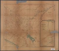
Description:
Imperfect. Mutilated with possible loss of text. and Inset: "Region explorada por el senador por Loreto D. Enrique S. Llosa", scale 1:500,000.
Publisher:
Sociedad Geografica de Lima ,
Subject (Geographic):
Peru--Maps
Found in:
Beinecke Rare Book and Manuscript Library > Mapa de las vias nacionales entre el Pacifico v el Rio Madre de Dios.
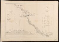
Published / Created:
1857
Call Number:
97 L62 1857
Container / Volume:
BRBL_00678
Image Count:
1
Resource Type:
Maps, Atlases & Globes
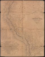
Description:
Includes charts of altitudes and distances. and Stamp and ms. on verso: "Yale University Map Collection gift of Hiram Bingham", "Hiram Bingham Bought of Chardenat August 1913".
Publisher:
Lit. E. Prugue y Midroit,
Subject (Geographic):
Peru--Maps
Subject (Name):
Bingham, Hiram,--1831-1908.--Ownership
Found in:
Beinecke Rare Book and Manuscript Library > Mapa del Camino de Lima à Cerro de Pasco.
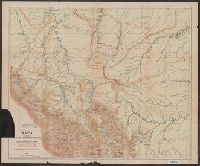
Published / Created:
1873
Call Number:
9713 1873
Container / Volume:
BRBL_00678
Image Count:
1
Resource Type:
Maps, Atlases & Globes
Description:
List of altitudes in margin.
Publisher:
Engraved by J.S. & A.B. Wyon,
Subject (Geographic):
Peru--Maps
Found in:
Beinecke Rare Book and Manuscript Library > Mapa del Peru, Departamento de Anchachs : con la nueva provincia Dos de Mayo del Departo. de Huanuco / por A. Raimondi.
Creator:
Published / Created:
1907
Call Number:
97 1907
Container / Volume:
BRBL_00677
Image Count:
1
Resource Type:
Maps, Atlases & Globes
Description:
Covers the region north of Cuzco, from Cerro de Pasco to the Bolivian Brazilian borders. and Imperfect. Mutilated with possible loss of text.
Publisher:
Carlos Fabbri,
Subject (Geographic):
Bolivia--Boundaries--Peru--Maps, Brazil--Boundaries--Peru--Maps, Peru--Boundaries--Bolivia--Maps, Peru--Boundaries--Brazil--Maps, and Peru--Maps
Found in:
Beinecke Rare Book and Manuscript Library > Mapa del alto Yurua y alto Purus que comprende las ultimas exploraciones y estudios verificados desde 1900 hasta 1906 [cartographic material] / mandado levantar por el Coronel D. Pedro Portillo indicando en tinta roja el ruḿbo de su viaje en 1900 y el ú
Published / Created:
1909
Call Number:
97 1909
Container / Volume:
BRBL_00678
Image Count:
1
Resource Type:
Maps, Atlases & Globes
Publisher:
Carlos Fabbri,
Subject (Geographic):
Peru--Maps
Found in:
Beinecke Rare Book and Manuscript Library > Mapa general del Peru : trazado, correjido y aumentado segun los mapas oficiales.
Published / Created:
[1860?].
Call Number:
97 1860
Container / Volume:
BRBL_00677
Image Count:
1
Resource Type:
Maps, Atlases & Globes
Description:
Inset: Plan of the city of Lima.
Publisher:
s.n.,
Subject (Geographic):
Bolivia--Maps, Ecuador--Maps, and Peru--Maps
Found in:
Beinecke Rare Book and Manuscript Library > Mapa general del Peru, Ecuador y Bolivia : corregido y aumentado considerablemente, con el Plano de la Capital del Peru.
Published / Created:
1904
Call Number:
97 1904
Container / Volume:
BRBL_00677
Image Count:
1
Resource Type:
Maps, Atlases & Globes
Description:
Map text continues outside neat line., Mounted on linen., and Waterways noted in blue
Publisher:
Sociedad Geografica de Lima ,
Subject (Geographic):
Peru--Maps
Found in:
Beinecke Rare Book and Manuscript Library > Mapa indicando el resultado de las ultimas exploraciones en los rios Paucartambo y Madre de Dios.
Branch:v1.64.0 ,Deployed:2024-09-11T10:25:15-04:00