Skip to search
Skip to main content
Skip to first result
Search
You Searched For
Subject (Geographic)
Poland--Maps
Search Results
Published / Created:
1811
Call Number:
356 1772-1811
Container / Volume:
BRBL_00113
Image Count:
1
Resource Type:
Maps, Atlases & Globes
Publisher:
J. Cary,
Subject (Geographic):
Poland--Maps
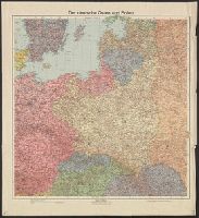
Found in:
Beinecke Rare Book and Manuscript Library > A new map of Poland and the Grand Duchy of Lithuania ... between Austria, Russia, and Prussia in 1772, 1793, & 1795 ... By John Cary, Engraver. 1811.
Creator:
Published / Created:
[1914?]
Call Number:
356 1915
Container / Volume:
BRBL_00114
Image Count:
1
Resource Type:
Maps, Atlases & Globes
Alternative Title:
Flemmings Kriegskarte ; Nr. 15
Publisher:
Carl Flemming, A.G.,
Subject (Geographic):
Poland--Maps
Subject (Topic):
World War, 1914-1918--Poland--Maps
Found in:
Beinecke Rare Book and Manuscript Library > Der Kriegsschauplatz in Polen.
Creator:
Published / Created:
[1918?]
Call Number:
356 1918
Container / Volume:
BRBL_00114
Image Count:
1
Resource Type:
Maps, Atlases & Globes
Alternative Title:
Velhagen & Klasings Karte, der deutsche Osten und Polen and Velhagen und Klasings Karte, der deutsche Osten und Polen
Publisher:
Verlag von Velhagen & Klasing,
Subject (Geographic):
Germany (East)--Maps and Poland--Maps
Found in:
Beinecke Rare Book and Manuscript Library > Der deutsche Osten und Polen.
Creator:
Published / Created:
[1915?]
Call Number:
352 1915D
Container / Volume:
BRBL_00105
Image Count:
2
Resource Type:
Maps, Atlases & Globes
Alternative Title:
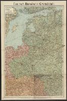
Karte der Deutsch-Russischen Grenzlande
Description:
Mounted on linen. Front, back covers affixed to verso.
Publisher:
Verlag von Velhagen & Klasing,
Subject (Geographic):
Europe, Central--Boundaries--Maps, Europe, Central--Maps, Europe, Eastern--Boundaries--Maps, Germany--Boundaries--Russia--Maps, Hungary--Maps, Poland--Maps, and Russia--Maps
Found in:
Beinecke Rare Book and Manuscript Library > Deutsch-Russische Grenzlande / Geographische Anstalt von Velhagen & Klasing ; Druck von C. Schönert.
Creator:
Published / Created:
1918
Call Number:
36ed 1918
Container / Volume:
BRBL_00127
Image Count:
2
Resource Type:
Maps, Atlases & Globes
Alternative Title:
GSGS (Series) ; 3703a. and GSGS ; 3703a
Description:
Germany -- Poland -- Northern Italy -- South east Europe.
Publisher:
War Office,
Subject (Geographic):
Balkan Peninsula--Maps, Germany--Maps, Italy, Northern--Maps, and Poland--Maps
Found in:
Beinecke Rare Book and Manuscript Library > Ethnographical map [cartographic material].
Published / Created:
[1917?]
Call Number:
36hc 1917a
Container / Volume:
BRBL_00133
Image Count:
1
Resource Type:
Maps, Atlases & Globes
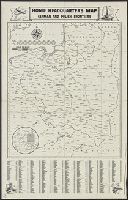
Description:
Index to names in margins.
Publisher:
Hobian Map Co.,
Subject (Geographic):
Germany--Maps and Poland--Maps
Subject (Name):
C.S. Hammond & Company Stamp
Subject (Topic):
World War, 1914-1918--Maps
Found in:
Beinecke Rare Book and Manuscript Library > Home Headquarters Map : German and Polish Frontiers.
Published / Created:
1925?]
Call Number:
356 1925
Container / Volume:
BRBL_00114
Image Count:
1
Resource Type:
Maps, Atlases & Globes
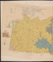
Description:
Panel title.
Publisher:
s.n.,
Subject (Geographic):
Poland--Maps
Found in:
Beinecke Rare Book and Manuscript Library > Karte von Polen.
Creator:
Published / Created:
1917
Call Number:
11hc 1917F
Container / Volume:
BRBL_00010D
Image Count:
2
Resource Type:
Maps, Atlases & Globes
Alternative Title:
Western battle front no. 1, Nieuport to Reims and Western battle front, Reims, France to Basel, Switzerland
Description:
Includes 3 insets: Russo-German war front -- [Franco-German border] -- Pozieres and environs.
Publisher:
Geographical Publishing Co.,
Subject (Geographic):
Europe--Maps, France--Maps, Germany--Maps, Poland--Maps, and Russia--Maps
Subject (Topic):
World War, 1914-1918--Europe--Maps, World War, 1914-1918--France--Maps, World War, 1914-1918--Germany--Maps, World War, 1914-1918--Poland--Maps, and World War, 1914-1918--Russia--Maps
Found in:
Beinecke Rare Book and Manuscript Library > Map of the Franco-German war front : from Hirson, France to Basel, Switzerland, and the Russo-German war front from Riga, Russia, to Lemberg, Austria / Published for the Volume Library.
Creator:
Published / Created:
1918
Call Number:
356fd 1918A
Container / Volume:
BRBL_00114
Image Count:
1
Resource Type:
Maps, Atlases & Globes
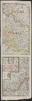
Alternative Title:
GSGS (Series) ; 2888.
Description:
Shows boundaries of Poland in 1772, 1793, 1795 and 1815. To illustrate the post-WW1 settlement.
Publisher:
GSGS, War Office,
Subject (Geographic):
Belarus--Maps, Lithuania--Maps, Poland--Maps, and Ukraine--Maps
Found in:
Beinecke Rare Book and Manuscript Library > Partitions of Poland [cartographic material] : GSGS 2888.
Published / Created:
191-.
Call Number:
11hcf 1919A-8
Container / Volume:
BRBL_00010N
Image Count:
1
Resource Type:
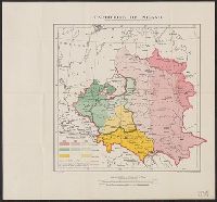
Maps, Atlases & Globes
Description:
Shows boundaries and populations.
Publisher:
s.n.,
Subject (Geographic):
Lithuania--Maps and Poland--Maps
Found in:
Beinecke Rare Book and Manuscript Library > Poland and Lithuania : a rough sketch of distribution of nationalities.