Skip to search
Skip to main content
Skip to first result
Yale University Library
Saved Items
Access Requests
Ask Yale Library
Reserve Rooms
Places to Study
Research
Search Quicksearch
Search Library Catalog
Search Digital Collections
Search Archives at Yale
Research Guides
Find Databases by Title
Find eJournals by Title
Guide to Using Special Collections
Services
Request Digital Copies of Special Collections
Your Personal Librarian
Subject Specialists
Research Support and Workshops
Citation Tools
Get It @ Yale (Borrow Direct, Interlibrary Loan, Scan & Deliver)
Course Reserves
Off-Campus Access
EliScholar
OverDrive: Popular Audio and eBooks
Bass Media Equipment
Libraries & Collections
Arts Library
Bass Library
Beinecke Library
Classics Library
Divinity Library
Yale Film Archive
Fortunoff Archive
Humanities Collections
International Collections
Law Library
Lewis Walpole Library
Library Collection Services
Manuscripts & Archives
Map Collection
Marx Science & Social Science Library
Medical Library
Music Library
Sterling Library
Yale Center for British Art
Information & Policies
Library Hours
Departments & Staff
Borrowing & Circulation
Services for Persons with Disabilities
Copyright Basics
Scanning, Printing & Copying
Computers & Wireless
Library Policies
About the Library
Giving to the Library
Purchase Request
Working at the Library
Terms Governing Use of Materials
Search in
All Fields
Creator
Title
Call Number
Date
Subject
Orbis ID
Full Text
Description
Full text
search for
Search
Search
Advanced Search
Digital Collections
Search
You Searched For
Subject (Geographic)
Shandong Sheng (China)--Maps
New Search
1
-
3
of
3
Sort
by Relevance
Relevance
Creator (A --> Z)
Creator (Z --> A)
Title (A --> Z)
Title (Z --> A)
Year (ascending)
Year (descending)
Number of results to display per page
9
per page
9
per page
30
per page
60
per page
99
per page
View results as:
List
List
Gallery
Gallery
Search Results
1.
Karte von Tschili und Schantung / bearbeitet in der Kartogr. Abteilung der Kgl. Preuss. Landesaufnahme, 1907.
Creator:
Prussia. Landesaufnahme. Kartographische Abteilung
Published / Created:
1907
Call Number:
5615 1907
Container / Volume:
BRBL_00299
Image Count:
2
Resource Type:
Maps, Atlases & Globes
Description:
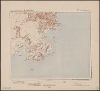
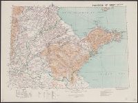
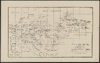
Covers all of Shandong Province and southern Hebei Province.
Publisher:
Kartogr. Abteilung der Kgl. Preuss. Landesaufnahme,
Subject (Geographic):
Beijing Region (China)--Maps, Hebei Sheng (China), Shandong Sheng (China)--Maps, and Tianjin Region (China)--Maps
Found in:
Beinecke Rare Book and Manuscript Library
>
Karte von Tschili und Schantung / bearbeitet in der Kartogr. Abteilung der Kgl. Preuss. Landesaufnahme, 1907.
2.
Province of Shan-tung [cartographic material] / compiled in the Topographical section, General staff.
Creator:
Great Britain. War Office. General Staff. Geographical Section
Published / Created:
1905
Call Number:
5616 1905
Container / Volume:
BRBL_00299
Image Count:
1
Resource Type:
Maps, Atlases & Globes
Alternative Title:
GSGS (Series) ; 1936., Province of Shandong, and T.S.G.S. ; no. 1936
Description:
Includes an English, Chinese explanation and a list of sources of information.
Publisher:
Reproduced and printed for the Topographical Section, General Staff, at the Ordnance Survey Office,
Subject (Geographic):
Shandong Sheng (China)--Maps
Found in:
Beinecke Rare Book and Manuscript Library
>
Province of Shan-tung [cartographic material] / compiled in the Topographical section, General staff.
3.
Shantung, China / compiled by Alex Armstrong, F.E.I.S.
Published / Created:
1865?]
Call Number:
5616 1865
Container / Volume:
BRBL_00299
Image Count:
1
Resource Type:
Maps, Atlases & Globes
Publisher:
s.n.,
Subject (Geographic):
Shandong Sheng (China)--Maps
Found in:
Beinecke Rare Book and Manuscript Library
>
Shantung, China / compiled by Alex Armstrong, F.E.I.S.
Limit your search
Extent of Digitization
Completely digitized
3
Access
Public
3
Repository
Beinecke Rare Book and Manuscript Library
3
Format
cartographic
3
Genre
Maps
3
Resource Type
Maps, Atlases & Globes
3
Language
Chinese
2
English
2
German
1
Creator
Great Britain. War Office. General Staff. Geographical Section
1
Prussia. Landesaufnahme. Kartographische Abteilung
1
Publication Place
Southampton :
1
[Prussia] :
1
[S.l. :
1
Date Created
View distribution
Current results range from
1865
to
1907
Date Created range begin
Date Created range end
View larger ยป