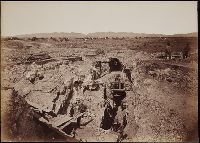
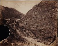
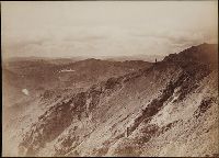
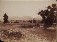
Photographs created from mammoth plate negatives primarily by photographers Carleton E. Watkins and William Henry Jackson of various locations in the American West, primarily in the states of California, Colorado, and Oregon, as well as Arizona, Monta...
Description:
A mammoth plate is a photographic negative plate, 18 by 21 inches (53.5 x 45.7 cm.) or larger, from which photographic prints are made through contact printing.
Subject (Geographic):
Wyoming, Montana, West (U.S.), Arizona, Arkansas River, Austin Bluffs (Colo.), Black Canyon of the Gunnison (Colo.), Blue Lakes (Calif.), Bridal Veil Falls (Utah), California, Cathedral Rocks (Calif.), Cathedral Spires (El Paso County, Colo.), Cathedral Spires (Jefferson County, Colo.), Clear Creek Canyon (Colo.), Clear Creek County (Colo.), Cochise Stronghold (Ariz.), Colorado, Columbia River, Costilla County (Colo.), Curecanti Needle (Colo.), Dalles (Or.), Dragoon Mountains (Ariz.), Drumlummon Mine (Mont.), Eagle Creek (Or.), Echo (Utah), El Capitan (Calif.), El Paso County (Colo.), Fountain Creek (Colo.), Fremont County (Colo.), Garden of the Gods (Colorado Springs, Colo.), Garfield County (Colo.), Gate Rock (El Paso County, Colo.), Giant Geyser (Wyo.), Glenwood Springs (Colo.), Grotto Geyser (Wyo.), Gunnison County (Colo.), Gunnison River (Colo.), Half Dome (Calif.), Jefferson County (Colo.), Jerome County (Idaho), Lake Vineyard (San Gabriel, Calif.), Marysville (Lewis and Clark County, Mont.), Mokelumne River (Calif.), Monument Park (El Paso County, Colo.), Multnomah County (Or.), Multnomah Creek (Or.), Multnomah Falls (Or.), North Cheyenne Canyon (Colo.), North Cheyenne Creek (Colo.), North Fork American River (Calif.), Old Faithful Geyser (Wyo.), Oregon, Palisades Falls, Pikes Peak (Colo.), Platte Canyon (Colo.), Port Ludlow (Wash.), Port Madison (Bainbridge Island, Wash.), Provo Canyon (Utah), Provo River (Utah), Pulpit Rock (Utah), Pulpit Terrace (Wyo.), Rainbow Falls (Colo.), Rio Arriba County (N.M.), Rio de los Pinos (Colo. and N.M.), Round Top Mountain (Calif.), Royal Gorge (Colo.), San Gabriel (Calif.), Sentinel Rock (Calif.), Seven Falls (Colo.), Sierra Blanca (Colo.), Snake River (Wyo.-Wash.), Soda Springs (Calif.), South Cheyenne Canyon (Colo.), South Cheyenne Creek (Colo.), South Platte River (Colo. and Neb.), Spokane (Wash.), Spokane River (Idaho and Wash.), Teller County (Colo.), Toltec Gorge (N.M.), Tombstone (Ariz.), Tombstone Region (Ariz.), Twin Creek (Colo.), Twin Falls (Idaho : Waterfalls), Utah, Ute Pass (Teller County, Colo.), Washington (State), Yampah Hot Springs (Colo.), Yellowstone National Park, Yosemite National Park (Calif.), and Yosemite Valley (Calif.)
Subject (Name):
Haynes, F. Jay 1853-1921. (Frank Jay),, Jackson, William Henry, 1843-1942., Meeker, Ezra, 1830-1928., Watkins, Carleton E., 1829-1916., Colorado Central Railroad Company, Denver and Rio Grande Railroad Company, Denver, South Park, and Pacific Railroad Company, Mission San Gabriel Arcangel (San Gabriel, Calif.), and Tough Nut Mine
Subject (Topic):
Geysers, Landscape photography, Mineral industries, and Railroads