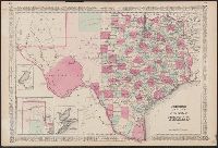
"46" and "47.", Insets: Plan of Sabine Lake. Scale [ca. 1:500,000] -- Plan of the northern part of Texas. Scale [ca. 1:3,700,000] -- Plan of Galveston Bay. Scale [ca.1:777,741]., Prime meridians: Greenwich and Washington., Relief shown by hac, and Shows counties.
Publisher:
s.n.,
Subject (Geographic):
Texas Panhandle (Tex.)--Maps, Texas--Administrative and political divisions--Maps, and Texas--Maps
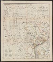
Includes list of counties and area map., Prime meridians: Paris and Ferro., Relief shown by hachures., and Shows counties, colonies, tracts numbered 1-12 surveyed by Le Grand, and parts of Indian Territory.
Publisher:
s.n.,
Subject (Geographic):
Texas--Administrative and political divisions--Maps and Texas--Maps
Plan of operations at the battle of Monterey on the 21st, 22nd & 23rd Sept., 1846.
Description:
"Entered according to act of Congress in the year 1847 by House & Brown ....", Includes distance table, ill. of "Castle of San Juan d'Ulloa," and text., and Insets: Plan of operations at the battle of Monterey on the 21st, 22nd & 23rd Sept., 1846 -- Map of Vera Cruz and San Juan de Ulloa.
Publisher:
House & Brown,
Subject (Geographic):
California--Maps, Mexico--Maps, Southwest, New--Maps, and Texas--Maps
Plan of operations at the battle of Monterey on the 21st, 22nd & 23rd Sept., 1846.
Description:
"Entered according to act of Congress in the year 1847 by House & Brown ....", Insets: Plan of operations at the battle of Monterey on the 21st, 22nd & 23rd Sept., 1846 -- Map of Vera Cruz and San Juan de Ulloa., Prime meridians: Greenwich and Washington., and Relief shown by hachures.
Publisher:
House & Brown?,
Subject (Geographic):
California--Maps, Mexico--Maps, Southwest, New--Maps, and Texas--Maps
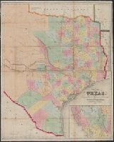
"Entered according to Act of Congress in the year 1839, by J.H. Colton, in the Clerks Office of the District Court of the Southern District of New York.", Library's copy annotated in pencil and orange ink., Prime meridians: Greenwich and Washington., and Relief shown by hachures.
Publisher:
J.H. Colton,
Subject (Geographic):
Texas--Administrative and political divisions--Maps and Texas--Maps
Subject (Name):
J.H. Colton & Co, Randel, Jesse F, and Stiles, Sherman & Smith
"Entered according to act of Congress in the year 1851 by Sherman & Smith in the clerks office of the district court for the southern district of New York.", Includes text and "Map of New Mexico, California, and Ut, Relief shown by hachures., and Shows counties.
Publisher:
s.n.],
Subject (Geographic):
Texas--Administrative and political divisions--Maps and Texas--Maps
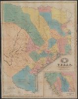
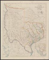
From the Streeter collection., Includes area map and ancillary map of "Plan of Galveston Bay from a ms.", Relief shown by hachures., and Shows 31 counties, notes from Le Grand's survey, various routes, "Fisher & Comp.y" northwest of Austin, "Al Bourgeois d'Orvanne's Grant" west of San Antonio, and names for projected land holdings, "Mr. Kennedy", "Mr. H. Castro", and "Mr. Pierson."
Publisher:
John Arrowsmith,
Subject (Geographic):
Texas--Administrative and political divisions--Maps and Texas--Maps
Subject (Name):
Arrowsmith, John, 1790-1873. London atlas of universal geography
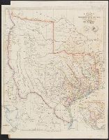
Appears in Arrowsmith's London atlas of universal geography., From the Streeter collection., Includes area map and ancillary map of "Plan of Galveston Bay from a ms.", Library's copy annotated in pencil., Relief shown by hachures., and Shows 31 counties, notes from Le Grand's survey, and various routes.
Publisher:
John Arrowsmith,
Subject (Geographic):
Texas--Administrative and political divisions--Maps and Texas--Maps
Subject (Name):
Arrowsmith, John, 1790-1873. London atlas of universal geography