Skip to search
Skip to main content
Skip to first result
Search
You Searched For
Subject (Geographic)
Turkey--Maps
Search Results
Published / Created:
1916
Call Number:
11hcf 1919B-37
Image Count:
1
Resource Type:
Maps, Atlases & Globes
Description:
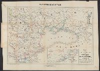
Dessiné et gravé par R. et A. Hausermann.
Publisher:
Augustin Challamel, Éditeur,
Subject (Geographic):
Balkan Peninsula--Maps, Caucasus--Maps, Middle East--Maps, Russia, Southern--Maps, and Turkey--Maps
Subject (Topic):
World War, 1914-1918--Maps
Found in:
Beinecke Rare Book and Manuscript Library > La Guerre en Orient : Extrait de la Carte Générale d'Europe / Marcel Dubois et J.G. Kergomard.
Creator:
Published / Created:
1916
Call Number:
53 1916A
Container / Volume:
BRBL_00285
Image Count:
1
Resource Type:
Maps, Atlases & Globes
Description:
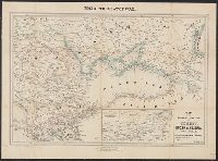
"Supplément à l'Illustration.", In upper right corner: 22 Avril 1916., and Relief shown by hachures.
Publisher:
s.n.],
Subject (Geographic):
Iran--Maps, Middle East--Maps, and Turkey--Maps
Subject (Topic):
World War, 1914-1918--Middle East--Maps and World War, 1914-1918--Turkey--Maps
Found in:
Beinecke Rare Book and Manuscript Library > Les fronts d'Asie : de Salonique au Golfe Persique du Caucase a l'Isthme de Suez / G. Peltier, delt.
Creator:
Published / Created:
[1862?]
Call Number:
53 1862
Container / Volume:
BRBL_00284
Image Count:
1
Resource Type:
Maps, Atlases & Globes
Description:
Inset: Large Scale Map of the Danube.
Publisher:
Letts, Son & Co.,
Subject (Geographic):
Balkan Peninsula--Maps, Caucasus--Maps, and Turkey--Maps
Found in:
Beinecke Rare Book and Manuscript Library > Letts's General Map of Russia & Turkey.
Creator:
Published / Created:
[1901]
Call Number:
3546 1901
Container / Volume:
BRBL_00113
Image Count:
1
Resource Type:
Maps, Atlases & Globes
Description:
Also covers Azerbaydzhan, southern Georgia, and northeastern Turkey., Imperfect: Mutilated with loss of text., In right lower margin: Stanford's Geographical Establishment., and Relief shown by shading and spot heights.
Publisher:
Longmans & Co.,
Subject (Geographic):
Armenia--Maps, Azerbaijan--Maps, Georgia (Republic)--Maps, and Turkey--Maps
Subject (Name):
Edward Stanford Ltd, Longman (Firm), Oswald, Felix, 1866-1958, and Shawe, W
Found in:
Beinecke Rare Book and Manuscript Library > Map of Armenia and adjacent countries / by H.F.B. Lynch & F. Oswald. The material compiled by W. Shawe. 1901.
Published / Created:
[1849?]
Call Number:
501 1849
Container / Volume:
BRBL_00276
Image Count:
1
Resource Type:
Maps, Atlases & Globes
Publisher:
Jas. Wyld,
Subject (Geographic):
Turkey--Maps
Found in:
Beinecke Rare Book and Manuscript Library > Map of the Ottoman Dominions in Asia with the adjacent frontiers of the Russian and Persian Empires.
Creator:
Published / Created:
[1854]
Call Number:
491 1853A
Container / Volume:
BRBL_00269
Image Count:
2
Resource Type:
Maps, Atlases & Globes
Alternative Title:
Map of the seat of war and Seat of war in the East.
Description:
At head of map: Map of the seat of war., Cover title: The seat of war in the east : a new map of the frontier provinces of Turkey, Russia & Austria, the Black Sea, &c., and Inset: Map showing in detail the Mouths & part of the River Danube, with the fortified t
Publisher:
Published by Willmer & Rogers, Importers of Foreign Books & Newspapers, 42 & 44 Nassau Street,
Subject (Geographic):
Austria--Maps, Black Sea--Charts, maps, etc, Danube River--Charts, diagrams, etc, Russia (Federation)--Maps, and Turkey--Maps
Subject (Name):
Bevan & Boell (Firm)
Subject (Topic):
Crimean War, 1853-1856--Maps
Found in:
Beinecke Rare Book and Manuscript Library > Map of the frontier provinces of Turkey, Russia & Austria, the Black Sea, & c [cartographic material] / Lith. by Bevan & Boell, 163 Broadway N.Y.
Creator:
Published / Created:
[1854]
Call Number:
53hc 1878
Container / Volume:
BRBL_00287
Image Count:
1
Resource Type:
Maps, Atlases & Globes
Alternative Title:
Map of the seat of war and Seat of war in the East.
Description:
At head of map: Map of the seat of war., Cover title: The seat of war in the east : a new map of the frontier provinces of Turkey, Russia & Austria, the Black Sea, &c., and Inset: Map showing in detail the Mouths & part of the River Danube, with the fortified t
Publisher:
Published by Willmer & Rogers, Importers of Foreign Books & Newspapers, 42 & 44 Nassau Street,
Subject (Geographic):
Austria--Maps, Black Sea--Charts, maps, etc, Danube River--Charts, diagrams, etc, Russia (Federation)--Maps, and Turkey--Maps
Subject (Name):
Bevan & Boell (Firm)
Subject (Topic):
Crimean War, 1853-1856--Maps
Found in:
Beinecke Rare Book and Manuscript Library > Map of the frontier provinces of Turkey, Russia & Austria, the Black Sea, & c [cartographic material] / Lith. by Bevan & Boell, 163 Broadway N.Y.
Creator:
Published / Created:
[between 1919 and 1930]
Call Number:
53 1923
Container / Volume:
BRBL_00285
Image Count:
1
Resource Type:
Maps, Atlases & Globes
Publisher:
Near East Relief,
Subject (Geographic):
Armenia--Maps, Middle East--Maps, and Turkey--Maps
Found in:
Beinecke Rare Book and Manuscript Library > Near East Relief.
Creator:
Published / Created:
[1918?]
Call Number:
53 1917
Container / Volume:
BRBL_00285
Image Count:
1
Resource Type:
Maps, Atlases & Globes
Alternative Title:
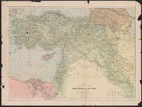
Mesopotamia & Asia Minor, Mesopotamia and Asia Minor, and Philips' strategical map of Mesopotamia and Asia Minor
Description:
Imperfect: Frayed, torn and repaired along folds., Relief shown by hachures., and Shows railways, submarine cables and steamship routes.
Publisher:
George Philips & Son,
Subject (Geographic):
Iraq--Maps, Middle East--Maps, and Turkey--Maps
Found in:
Beinecke Rare Book and Manuscript Library > Philips' strategical map of Mesopotamia & Asia Minor / George Philip & Son, ltd.
Published / Created:
1838
Call Number:
501 K14 1838
Container / Volume:
BRBL_00276
Image Count:
1
Resource Type:
Maps, Atlases & Globes
Description:
4 plans on one sheet., Plan der Umgegend von Kiutachia 1:25,000., Plan von Afium-Kara-Hissar 1:25,000., and Situations Plan der Stadt Brussa 1:25,000.
Publisher:
Simon Schropp & Co.,
Subject (Geographic):
Turkey--Maps
Found in:
Beinecke Rare Book and Manuscript Library > Plan der Stadt Karaman und der Umgegend. Fischer.
Branch:v1.68.0 ,Deployed:2025-05-14T09:23:12-04:00